Equus
Member
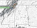
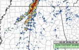
Spann is extremely reserved and careful with wording; the death toll on 4/27 has left him with a lot of unwarranted self blame that has made him extremely concerned with public messaging during severe events. Almost never uses the V word, so seeing him go with that two days before the event is unsettling. First time I've gotten storm anxiety personally in a very long time