
Navigation
Install the app
How to install the app on iOS
Follow along with the video below to see how to install our site as a web app on your home screen.
Note: This feature may not be available in some browsers.
More options
-
Welcome to TalkWeather! We see you lurking around TalkWeather! Take the extra step and join us today to view attachments, see less ads and maybe even join the discussion. CLICK TO JOIN TALKWEATHER
You are using an out of date browser. It may not display this or other websites correctly.
You should upgrade or use an alternative browser.
You should upgrade or use an alternative browser.
Severe WX Severe Weather Threat 3/14-3/16
- Thread starter Bulkshear
- Start date
KevinH
Member
we’ll see what happens
Wow. WVTM 13 in central Alabama is already declaring next Saturday a weather impact day. I've never seen that before being a week out and all. (Maybe April 28th 2014 event I might have)

 www.wvtm13.com
Destruction in Alabama: Deadly tornadoes obliterate buildings, homes and trees
WVTM 13 was live with team coverage for more than nine hours on Saturday during two dozen Central Alabama Tornado Warnings.
www.wvtm13.com
Yup
- Thread starter
- #5
Bulkshear
Member
I’m not so sure this won’t matter all that much. The disruption from the first system should be minimal since the storm is hugging the coast. The moisture should be able to still advect northward. How far will it make it? The power of this storm could overcome these obstacles or am I off base here?
It's enough disruption to cause the caliber of this event to go down some, I think in general areas in the deep south are in for a nasty two days (Ark/La/Tex and MS/AL). Either which away of how bad this system will be; This event tops what the last events ceiling could have been. You don't want this event to reach it's potential.I’m not so sure this won’t matter all that much. The disruption from the first system should be minimal since the storm is hugging the coast. The moisture should be able to still advect northward. How far will it make it? The power of this storm could overcome these obstacles or am I off base here?
- Thread starter
- #7
Bulkshear
Member
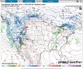
Newest GFS isn’t showing much moving across the SE on 3/13….It's enough disruption to cause the caliber of this event to go down some, I think in general areas in the deep south are in for a nasty two days (Ark/La/Tex and MS/AL). Either which away of how bad this system will be; This event tops what the last events ceiling could have been. You don't want this event to reach it's potential.
Attachments
- Thread starter
- #8
Bulkshear
Member
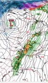
The 00z just increased CAPE by a good bit in the Midwest. Definetly not a trend you want to see. 18z gfs compared to 00z 

- Thread starter
- #10
Bulkshear
Member
- Moderator
- #11
Wow. WVTM 13 in central Alabama is already declaring next Saturday a weather impact day. I've never seen that before being a week out and all. (Maybe April 28th 2014 event I might have)
Destruction in Alabama: Deadly tornadoes obliterate buildings, homes and trees
WVTM 13 was live with team coverage for more than nine hours on Saturday during two dozen Central Alabama Tornado Warnings.
The fact Jason is doing that this far out does not give me the warm fuzzies.
slenker
Member
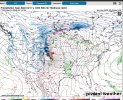
I’m disliking the uptick in activity being portrayed to the north. That preceding wave needs to scour the gulf, otherwise there’s major trouble brewing over a wide area.
Neat that the LLJ is basically going strong all the way into the extreme northern part of the Bay of Campeche early Saturday morning where mid 70s dewpoints will reside. 
Last edited:
tennessee storm chaser
Member
- Messages
- 1,877
- Reaction score
- 4,283
- Location
- jackson tennessee
- Special Affiliations
- SKYWARN® Volunteer
No doubt, gfs is wanting to turn this thing into a widespread all out outbreak …I’m disliking the uptick in activity being portrayed to the north. That preceding wave needs to scour the gulf, otherwise there’s major trouble brewing over a wide area.
Warm sector is still pinched a bit once the system moves east, At least for Alabama and Georgia. 7 days out though so we will see how that evolves. Still lots of moving pieces.No doubt, gfs is wanting to turn this thing into a widespread all out outbreak …
Georgia gets spared about 95% of the time by either the wedge or simple chronology, i.e. storms arriving at 4 A.M. Hoping this'll be the case once more.Warm sector is still pinched a bit once the system moves east, At least for Alabama and Georgia. 7 days out though so we will see how that evolves. Still lots of moving pieces.
Cyclonic Paracosm
Member
it keeps up trending, and atp I am dreading when the cams get a hold of this
CheeselandSkies
Member
I thought 0Z GFS had introduced capping issues as a failure mode for the northern end of Friday's setup...then I realized I was looking at the frames valid for 18Z.
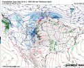
Northward moisture transport is extremely impressive, upper 50s as far north as southern Wisconsin with solid (perhaps even excessive, some forecast sounding profiles are saturated up to 700mb) depth. The area of 60s further south still isn't depicted as super wide, but wide enough.
Northward moisture transport is extremely impressive, upper 50s as far north as southern Wisconsin with solid (perhaps even excessive, some forecast sounding profiles are saturated up to 700mb) depth. The area of 60s further south still isn't depicted as super wide, but wide enough.
Cyclonic Paracosm
Member
funnnnI thought 0Z GFS had introduced capping issues as a failure mode for the northern end of Friday's setup...then I realized I was looking at the frames valid for 18Z.
Northward moisture transport is extremely impressive, upper 50s as far north as southern Wisconsin with solid (perhaps even excessive, some profiles are saturated up to 700mb) depth. The area of 60s further south still isn't depicted as super wide, but wide enough.
WeatherDan
Member
The most recent system notwithstanding, haven't models historically tended to underestimate the warm sector at this range?