• Welcome to TalkWeather!
    We see you lurking around TalkWeather! Take the extra step and join us today to view attachments, see less ads and maybe even join the discussion.
    CLICK TO JOIN TALKWEATHER

Severe Weather 2025

Considering buying a drone (got a little money to blow so why not lol ) for viewing some of these supercells/storms that come through northern Jefferson county. Maybe if we see something next weekend I'll have one and be able to get a birds eye view of the north Jefferson county tornado magnet.

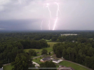
Drone pic from North Jefferson County. You should go ahead and take the plunge.
 

Attachments

  • IMG_2578.png
    IMG_2578.png
    6.4 MB · Views: 0
Why do you people keep doing this to yourself? Always assume it will be a nothingburger and be slightly to moderately surprised.
Nothing wrong with his statement. I sorta agree with it, he's not saying a mega tornado outbreak. Just saying a legitimate big threat is possible if we get a little more consistency, which is true. Nothing to sound the alarms yet but definitely a very intriguing look!
 
Considering buying a drone (got a little money to blow so why not lol ) for viewing some of these supercells/storms that come through northern Jefferson county. Maybe if we see something next weekend I'll have one and be able to get a birds eye view of the north Jefferson county tornado magnet.
Season 4 Reaction GIF by The Office
 
MEG nws Memphis is already starting sound alarm …
"Long-term operational and ensemble models indicate a stronger upper-level low deepening over the Central Plains Friday and move northeast into the Upper Midwest instability and favorable kinematics may be conducive by Friday night. Increasing some strong to severe perhaps for thunderstorms along with a potential for heavy rainfall. However, differences still remain with the timing and placement of an associated shortwave trough that will rotate through the Middle and Lower Mississippi Valleys. This will continue to be monitored over the next several days in subsequent model runs."
 
Considering buying a drone (got a little money to blow so why not lol ) for viewing some of these supercells/storms that come through northern Jefferson county. Maybe if we see something next weekend I'll have one and be able to get a birds eye view of the north Jefferson county tornado magnet.
I have a DJI Mini 2. My only problem with using it more is because most of our storms end up coming in at night. Too much wind is the other big issue. Other than that, I highly recommend getting one.
 
First High Risk for heavy precipitation since early last month. Crazy to see a Moderate Risk for High Winds over a very large swath of the U.S.
 

Attachments

  • precip_probhazards_d8_14_contours (5).png
    precip_probhazards_d8_14_contours (5).png
    1 MB · Views: 0
  • wind_probhazards_d8_14_contours (2).png
    wind_probhazards_d8_14_contours (2).png
    1 MB · Views: 0
Back
Top