
I would love to discuss further what you are seeing and what I'm seeing as far as pattern wise/analogs etc. Feel free to DM me.I'm going to say right now, given all of the data I've seen over the past couple of weeks looking forward to March and April, there is a considerably higher chance than normal of something bad (potentially multiple somethings) happening in the Mid South/SE this year.
Navigation
Install the app
How to install the app on iOS
Follow along with the video below to see how to install our site as a web app on your home screen.
Note: This feature may not be available in some browsers.
More options
-
Welcome to TalkWeather! We see you lurking around TalkWeather! Take the extra step and join us today to view attachments, see less ads and maybe even join the discussion. CLICK TO JOIN TALKWEATHER
You are using an out of date browser. It may not display this or other websites correctly.
You should upgrade or use an alternative browser.
You should upgrade or use an alternative browser.
Severe Weather 2025
- Thread starter KevinH
- Start date
- Thread starter
- #402
KevinH
Member
that seems to be a growing consensus lately… STILL TOO EARLY THOUGH…I'm going to say right now, given all of the data I've seen over the past couple of weeks looking forward to March and April, there is a considerably higher chance than normal of something bad (potentially multiple somethings) happening in the Mid South/SE this year.
Where is @Fred Gossage?!
")
- Thread starter
- #403
- Moderator
- #404
I've sent a "bat signal" to Fred, but he's a busy man. Hopefully he'll pop in to give his thoughts if he has a chance.
Austin Dawg
Member
Thanks for the directions. It works on the iPhone and on my desktop.just look up, weatherwise.app and ya get sent to a page with 3 options, the bottom one is a desktop webapp
CheeselandSkies
Member
In case anyone's interested, the media company the station I work for belongs to (not Allen, thankfully) airs a show called Investigate TV Plus. Today's episode is going to be about radar gaps and other severe weather-related issues. Check your local listings.
I see absolutely no reasons to disagree. You don't get a consistently high +TNI like we've been having coupled with a -PDO and the MJO consistently amplifying into the Indian Ocean with suppression over the Pacific as a seasonal thing and not have problems. Exiting out of a first-year La Nina of any intensity, all those things together simultaneously have historically meant significant problems in specifically the heart of Dixie Alley. The seasonal placement of the bookend ridges east/north of Hawaii and then out into the west Atlantic have been another clue toward trouble in the Southeast. After the first potential threat around the 4th-5th, I'm particularly interested in the period between March 11th and 17th for two potential systems that may ride through a longwave mean trough over the CONUS. Then, given timing of the MJO cycle we have and what the weeklies are already hinting at, I'd watch for a similar pattern to cycle back across in the second half of April. The combination of it cycling back across that early and the MJO placement being in the Indian Ocean versus the Pacific will mean the pattern will very likely not shift to our northwest when it cycles back across in the second half of April. It should still be pointed at the Southeast/MidSouth/Tennessee Valley general region.I'm going to say right now, given all of the data I've seen over the past couple of weeks looking forward to March and April, there is a considerably higher chance than normal of something bad (potentially multiple somethings) happening in the Mid South/SE this year.
Whatever specifics happen in both MJO cycles... that's up to individual synoptic systems to take advantage of the background environment, and that can't be speculated on too much with any real skill just yet (especially the likely April MJO cycle, we're almost in range for basic pattern recognition with this mid March one)... but the hemispheric-level table, so to speak, is fully set.
Last edited:
CheeselandSkies
Member
Making some compilations of all those chase days where I only got a few minutes of footage; maybe an ominous gust front, couple of cool lightning bolts or just some photogenic billowing convection. This one spans from 2013-'15.
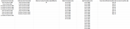
Not sure where to post this, but this is what I sent to a few notable people (notable as in meteorologists). At the time of this writing, I thought we would have a late February severe weather threat, but clearly that's not happening. This is just my perspective from what I've seen personally and from past analog data. As for our final freeze/frost, I would expect that to occur around Easter. I have hesitated to share this here just because of the year in question, but clearly, there's similarities to what has happened thus far. How March plays out will be key. Again, as both I, @andyhb, and @Fred Gossage have mentioned, Spring is looking to be more robust than in last few years based on overall pattern, ENSO, etc. In fact, a great meteorologist friend of mine today brought up precipitation and I hadn't even considered that. January 2025 ended up below normal at 4.74 inches for Tupelo (Normal is 4.82) and for Aberdeen, MS at 3.93 inches as well (Normal is 4.97).
Dec. 31st, 2010 vs. Dec. 28th, 2024
We had EF1 tornado in Monroe County, MS from a squall line that moved thru January 5th, 2025 and snow flurries on January 6th.
What did both the Dec 2010 and 2024 outbreaks have in common?
Both were followed by a Deep South snowstorm on January 10th (2011/2025)
Okay. What did February 2011 have in common with February 2025?
February 2011 had 4 severe weather outbreaks (3 Moderate).
February 2025 has had 5 severe weather events thus far (only 2 Enhanced).
February 5th, 2025 and February 15th, 2025 featured a Level 3 Enhanced Risk.
February 2011 featured a snow event on February 9th.
February 2025 featured a snow event on February 18th to 19th.
December 2010 had 36 tornadoes
December 2024 had 145 tornadoes
January 2025 had 20 tornadoes
January 2011 had 11 tornadoes
It was very cold both months so that's the reason for the lack of more tornadoes. Just a difference of 9.
February 2025 had has 37 tornadoes thus far
February 2011 had 61 tornadoes
Both have featured a battle between warm/cold and had mild spells in between.
March 2011 only featured 75 tornadoes (only 1 Moderate Risk out of 10 events that month). Moderate Risk was on March 23rd, 2011 in the Mid-Atlantic region.
The majority of the severe threats in March 2011 occurred just along the Gulf Coast states or further north (Iowa/Mid-Atlantic) prior to the 26th of March.
You still had a lot of cold air around in March which hindered moisture return off the Gulf severely limiting the threats further inland with the exception of March 23rd and 22nd. That's what I'm expecting to happen in March 2025.
Last edited:
- Thread starter
- #410
KevinH
Member
That late Feb severe event just got pushed back to early March is allNot sure where to post this, but this is what I sent to a few notable people (notable as in meteorologists). At the time of this writing, I thought we would have a late February severe weather threat, but clearly that's not happening. This is just my perspective from what I've seen personally and from past analog data. As for our final freeze/frost, I would expect that to occur around Easter. I have hesitated to share this here just because of the year in question, but clearly, there's similarities to what has happened thus far. How March plays out will be key. Again, as both I, @andyhb, and @Fred Gossage have mentioned, Spring is looking to be more robust than in last few years based on overall pattern, ENSO, etc. In fact, a great meteorologist friend of mine today brought up precipitation and I hadn't even considered that. January 2025 ended up below normal at 4.74 inches for Tupelo (Normal is 4.82) and for Aberdeen, MS at 3.93 inches as well (Normal is 4.97).
Dec. 31st, 2010 vs. Dec. 28th, 2024
We had EF1 tornado in Monroe County, MS from a squall line that moved thru January 5th, 2025 and snow flurries on January 6th.
What did both the Dec 2010 and 2024 outbreaks have in common?
Both were followed by a Deep South snowstorm on January 10th (2011/2024)
Okay. What did February 2011 have in common with February 2025?
February 2011 had 4 severe weather outbreaks (3 Moderate).
February 2025 has had 5 severe weather events thus far (only 2 Enhanced).
February 5th, 2025 and February 15th, 2025 featured a Level 3 Enhanced Risk.
February 2011 featured a snow event on February 9th.
February 2025 featured a snow event on February 18th to 19th.
December 2010 had 36 tornadoes
December 2024 had 145 tornadoes
January 2025 had 20 tornadoes
January 2011 had 11 tornadoes
It was very cold both months so that's the reason for the lack of more tornadoes. Just a difference of 9.
February 2025 had has 37 tornadoes thus far
February 2011 had 61 tornadoes
Both have featured a battle between warm/cold and had mild spells in between.
March 2011 only featured 75 tornadoes (only 1 Moderate Risk out of 10 events that month). Moderate Risk was on March 23rd, 2011 in the Mid-Atlantic region.
The majority of the severe threats in March 2011 occurred just along the Gulf Coast states or further north (Iowa/Mid-Atlantic) prior to the 26th of March.
You still had a lot of cold air around in March which hindered moisture return off the Gulf severely limiting the threats further inland with the exception of March 23rd and 22nd. That's what I'm expecting to happen in March 2025.
- Thread starter
- #411
KevinH
Member
Have there been any other years with such consistent similarities?Not sure where to post this, but this is what I sent to a few notable people (notable as in meteorologists). At the time of this writing, I thought we would have a late February severe weather threat, but clearly that's not happening. This is just my perspective from what I've seen personally and from past analog data. As for our final freeze/frost, I would expect that to occur around Easter. I have hesitated to share this here just because of the year in question, but clearly, there's similarities to what has happened thus far. How March plays out will be key. Again, as both I, @andyhb, and @Fred Gossage have mentioned, Spring is looking to be more robust than in last few years based on overall pattern, ENSO, etc. In fact, a great meteorologist friend of mine today brought up precipitation and I hadn't even considered that. January 2025 ended up below normal at 4.74 inches for Tupelo (Normal is 4.82) and for Aberdeen, MS at 3.93 inches as well (Normal is 4.97).
Dec. 31st, 2010 vs. Dec. 28th, 2024
We had EF1 tornado in Monroe County, MS from a squall line that moved thru January 5th, 2025 and snow flurries on January 6th.
What did both the Dec 2010 and 2024 outbreaks have in common?
Both were followed by a Deep South snowstorm on January 10th (2011/2025)
Okay. What did February 2011 have in common with February 2025?
February 2011 had 4 severe weather outbreaks (3 Moderate).
February 2025 has had 5 severe weather events thus far (only 2 Enhanced).
February 5th, 2025 and February 15th, 2025 featured a Level 3 Enhanced Risk.
February 2011 featured a snow event on February 9th.
February 2025 featured a snow event on February 18th to 19th.
December 2010 had 36 tornadoes
December 2024 had 145 tornadoes
January 2025 had 20 tornadoes
January 2011 had 11 tornadoes
It was very cold both months so that's the reason for the lack of more tornadoes. Just a difference of 9.
February 2025 had has 37 tornadoes thus far
February 2011 had 61 tornadoes
Both have featured a battle between warm/cold and had mild spells in between.
March 2011 only featured 75 tornadoes (only 1 Moderate Risk out of 10 events that month). Moderate Risk was on March 23rd, 2011 in the Mid-Atlantic region.
The majority of the severe threats in March 2011 occurred just along the Gulf Coast states or further north (Iowa/Mid-Atlantic) prior to the 26th of March.
You still had a lot of cold air around in March which hindered moisture return off the Gulf severely limiting the threats further inland with the exception of March 23rd and 22nd. That's what I'm expecting to happen in March 2025.
Not really outside of the snow in January and February. I did do a spreadsheet on Monroe County tornadoes vs. years with snow and years with no snow. To be honest, I never knew there was a snow vs. tornado relation until I did this spreadsheet. I got curious to see if there was a linkage and indeed there seems to be. This is why looking at analog and past weather events is SO IMPORTANT!Have there been any other years with such consistent similarities?
Attachments
Last edited:
DetectiveWX
Member
1936 would fit with this winter's pattern; it was Atlanta's snowiest winter on record with 10.5". Jan/Feb were super frigid; however, March saw signs of big trouble brewing with SE ridge taking over allowing the Gulf to recover substantially and the northern tier remaining frigid...then hell broke loose.
- Thread starter
- #414
KevinH
Member
This:1936 would fit with this winter's pattern; it was Atlanta's snowiest winter on record with 10.5". Jan/Feb were super frigid; however, March saw signs of big trouble brewing with SE ridge taking over allowing the Gulf to recover substantially and the northern tier remaining frigid...then hell broke loose.
1936 Cordele–Greensboro tornado outbreak - Wikipedia
Or this:
1936 Tupelo–Gainesville tornado outbreak - Wikipedia
- Thread starter
- #415
KevinH
Member
As we approach severe season, it might be good to review the guidelines (and associated vote) for posting:

 talkweather.com
talkweather.com
Long story short, no more posts that include multiple weather systems that cover several days “second half of April 2025”. Each event/weather system gets its own thread to be started not more than 8+ days. (Unless a mod makes a special approved exception)
Events/Outbreaks/outbreak sequences I think would be considered one event since they are created by the same weather system. Using dates of the event in the title thread is helpful
@MichelleH @WesL @Mike S, (and other mods/admins I don’t know about lol), please comment/clarify if you think it is warranted
PLEASE READ - Posting Guidelines For Severe Events
As you can imagine, during severe weather events the information comes quick. Our severe weather threads quickly become a great clearinghouse for information including warnings, storm reports, radar information and other interesting information. With all this information, screen space becomes...
PLEASE READ - Vote on a new policy concerning severe weather threads
Good day everyone. In the past few weeks, we tested a new concept of allowing long-term threads for multiple events (i.e. last half of April). Several of you have spoken out against this with some very valid reasons around being able to go back and find information from an event quickly...
Long story short, no more posts that include multiple weather systems that cover several days “second half of April 2025”. Each event/weather system gets its own thread to be started not more than 8+ days. (Unless a mod makes a special approved exception)
Events/Outbreaks/outbreak sequences I think would be considered one event since they are created by the same weather system. Using dates of the event in the title thread is helpful
@MichelleH @WesL @Mike S, (and other mods/admins I don’t know about lol), please comment/clarify if you think it is warranted
- Admin
- #416
- Messages
- 2,403
- Reaction score
- 2,229
- Location
- Meridianville, Al
- Special Affiliations
- SKYWARN® Volunteer
That pretty much covers it!As we approach severe season, it might be good to review the guidelines (and associated vote) for posting:
PLEASE READ - Posting Guidelines For Severe Events
As you can imagine, during severe weather events the information comes quick. Our severe weather threads quickly become a great clearinghouse for information including warnings, storm reports, radar information and other interesting information. With all this information, screen space becomes...
PLEASE READ - Vote on a new policy concerning severe weather threads
Good day everyone. In the past few weeks, we tested a new concept of allowing long-term threads for multiple events (i.e. last half of April). Several of you have spoken out against this with some very valid reasons around being able to go back and find information from an event quickly...
Long story short, no more posts that include multiple weather systems that cover several days “second half of April 2025”. Each event/weather system gets its own thread to be started not more than 8+ days. (Unless a mod makes a special approved exception)
Events/Outbreaks/outbreak sequences I think would be considered one event since they are created by the same weather system. Using dates of the event in the title thread is helpful
@MichelleH @WesL @Mike S, (and other mods/admins I don’t know about lol), please comment/clarify if you think it is warranted

More strengthening of that W-E dipole in SSTAs across the ENSO regions is likely coming, with cooling of the western regions (Nino 4) thanks to trade wind bursts (easterlies, upwelling) near/west of the dateline and warming of the eastern regions (Nino 1+2 and the eastern part of Nino 3) thanks to westerly anomalies (downwelling). The TNI (or Trans-Nino index) is the Nino 1+2 - Nino 4, so basically you're making it more positive when Nino 1+2 is warmer than usual and Nino 4 is colder than usual. This has historically been problematic for early season severe weather.
I see absolutely no reasons to disagree. You don't get a consistently high +TNI like we've been having coupled with a -PDO and the MJO consistently amplifying into the Indian Ocean with suppression over the Pacific as a seasonal thing and not have problems. Exiting out of a first-year La Nina of any intensity, all those things together simultaneously have historically meant significant problems in specifically the heart of Dixie Alley. The seasonal placement of the bookend ridges east/north of Hawaii and then out into the west Atlantic have been another clue toward trouble in the Southeast. After the first potential threat around the 4th-5th, I'm particularly interested in the period between March 11th and 17th for two potential systems that may ride through a longwave mean trough over the CONUS. Then, given timing of the MJO cycle we have and what the weeklies are already hinting at, I'd watch for a similar pattern to cycle back across in the second half of April. The combination of it cycling back across that early and the MJO placement being in the Indian Ocean versus the Pacific will mean the pattern will very likely not shift to our northwest when it cycles back across in the second half of April. It should still be pointed at the Southeast/MidSouth/Tennessee Valley general region.
Whatever specifics happen in both MJO cycles... that's up to individual synoptic systems to take advantage of the background environment, and that can't be speculated on too much with any real skill just yet (especially the likely April MJO cycle, we're almost in range for basic pattern recognition with this mid March one)... but the hemispheric-level table, so to speak, is fully set.
Just popping in to support Fred in his assessment. Fred and I have been working on this for the past few months. This is easily the most similar seasonal pattern to 2011 we've tracked since 2011, except we appear to be starting in March this time....
- Thread starter
- #419
KevinH
Member
Oh HELL….Just popping in to support Fred in his assessment. Fred and I have been working on this for the past few months. This is easily the most similar seasonal pattern to 2011 we've tracked since 2011, except we appear to be starting in March this time....
A little earlier, different location too or too early to tell?
More singles after next week threat.
