.LONG TERM...
(Today through next Wednesday)
Issued at 413 PM EST Thu Jan 9 2025
Key Messages:
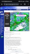
- A Winter Storm Warning has been issued across all of north
Georgia, Athens, the Atlanta metro, and points eastward
generally along and just south of I-20. A Winter Weather
Advisory has been issued for remaining counties north of a
line from approximately Columbus to Macon and NEward to
Augusta.
- Snow at onset is expected in the north Georgia mountains. 1-3"
will be possible before a switch to more sleet or freezing
rain may occur. New freezing rain amounts of 0.1" to 0.2" will
be possible on top of this. Expect significant impacts to
travel, especially on untreated roadways.
- In the metro of Atlanta and east into Athens and the Piedmont,
precipitation may start as snow and then switch to sleet.
Accumulations of 1-2" of sleet/snow will be possible.
Concerning in this area in the upward trend in freezing rain,
with amounts of up to a third of an inch possible. Expect
significant impacts to travel. Ice accumulations may lead to
some tree and powerlines impacts. A switch over to some rain
may be possible in this area later in the evening.
- Within the Winter Weather Advisory, an early burst of
snow/sleet/freezing rain may lead to some limited impacts
during the morning hours. Any accumulations should be limited
well under an inch of snow and a glaze of ice. Precip in
afternoon is not expected to be as heavy, and should remain
mostly rain.
Forecast:
The big headline up front in the forecast package is the issuance of
the Winter Storm Warning and Winter Weather Advisory across all of
north and much of central Georgia. Discussion of amounts and
thoughts on these will be found further below, beyond the summary
contained within the key messages. The Winter Storm Warning and
Advisory begin at 12Z (7 am) tomorrow. The Warning will carry
through until 7 am Saturday. The Advisory will carry through until 3
pm Friday. There will be travel impacts across much of the area
tomorrow that will begin during the morning hours. Travel is not
recommended. Stay home if possible. If not, please ensure you
allow plenty of extra time to get to your destination. Take it
slow and leave plenty of distance between you and others.
Within the synoptic setup, some interesting things to note within
the suite of model guidance this morning and into the afternoon.
First, cold air has been reinforced across the CWA as a quick
hitting shortwave has moved by the area. It's quite dry outside,
which will have big impacts on moving our wet bulb temperature as
precip begins to fall Friday morning. One interesting note in the
models in a bit of a battle as to where the surface low ends of
wanting to set up. Synoptic meteorology is on full display with this
system, as two waves, one within the subtropical flow, and one
diving out of the Arctic, phase as they push into the eastern CONUS.
To the southwest of this, a large wave remains behind extending into
Texas, allowing for an interesting look the upper levels. The two
waves merging to the north push by with a more negative tilt, while
the wave remaining to the southwest gives a more positive tilt
before eventually ejecting later into Saturday. This leads to a huge
PV streamer and strong PV gradient that extends across the
southeast, providing broad synoptic scale lift over a huge area.
Primary low has already formed across Texas, and looks to track
along the baroclinic zone established by the coastline as our cold
airmass pushes up against the warmer Gulf of Mexico.
Broad area of isentropic lift will occur ahead of the low as
moisture is lifted over our cool airmass, bringing an initial
wave of precip into the CWA Friday morning. Precip occurring with
this may take a bit to reach the ground. Dry air is entrenched
near the surface up to about 850mb in the CWA, which will allow us
to wetbulb to below freezing through the entire vertical column.
Initial precip type basically everywhere is expected to be snow.
As the low continues to move east, notable warm "nose" is noted
aloft at between 850mb and 700mb as the LLJ begins to kick in.
This will likely be responsible for our transition from snow to
sleet and freezing rain/just rain from south to north. The most
challenging part of the forecast is the surface temperatures
during this time period. Sleet/freezing rain require that the
raindrop refreeze at some point, the difference being whether that
occurs in the air or as it hits the ground. This requires cooling
the raindrop (removing heat) and a phase change to ice (removing
heat). That heat has to go somewhere, and the air, ground, and
objects are just that. So, generally we need something to help
offset this effect to stay at or below freezing to continue with
frozen precip types. For now, 2 possibilities seem to be present:
dry air filtering just above the surface, allowing for wetbulbing
to cool, and dynamic cooling from layers just above surface as
precipitation physically pulls that cooler air down (and that air
is still cooler than the environment when adjusted for adiabatic
descent with potential diabatic effects). An additional effect may
be the development of a in-situ wedge, which should prevent
surface WAA from encroaching too far to the north. Put all this
together, and our forecast surface temperatures are on the lower
end when compared to the model output. This keep frozen precip in
place longer, and has impacts on potential accumulations,
especially ice.
As the low moves by, temperatures may rise above freezing for a
brief period, especially as precip comes to an end, but should fall
again later in the night. Impacts should end west to east across the
CWA, with precip moving out by sunrise in eastern Georgia. Winds
will be the next thing to watch on Saturday as the system exits,
especially if we see ice impacts. Current expectations are some
gusts between 20-30 mph, especially during the afternoon hours if
sunlight comes out and mixing processes can get going. Another quick
wave will move by the area Saturday night. Saturday night will be
quite cold, with temperatures dipping into the teens and 20s across
the area. This will lead to refreezing on any roadways that have no
completely melted from Friday's system.
Breaking down potential impacts, starting with north Georgia:
- Snow/sleet amounts of between 1-3" with some higher amounts in
local areas. These amounts could increase if switchover to ice
is delayed longer than expected. This is a wet, heavy snow so
use caution when looking at snowfall maps that are typically
10:1. SLRs look to be closer to 5-7:1 for this event, which
will be a wet, heavy snow.
- Freezing rain amounts of 0.1"-0.2", mostly falling after snow
impacts. This may have some larger impacts than normal for
these amounts, as trees and powerlines may still have snow
stuck to them that could freeze in place, adding additional
weight. Power outages and tree fall will be possible. Roads
will be hazardous.
Impacts in Metro Atlanta, Athens, and the Piedmont:
- Snow/sleet amounts generally between 1-2". Most of this will
fall during the morning hours and will likely impact
commutes. Ground temperatures as noted on the UGA mesonet are
cold. This should allow snow to quickly begin to stick across
the area, especially if better snowfall rates begin. Expect
travel impacts. This will also be a wet heavy snow.
- Freezing rain amounts of 0.15-0.33". Switchover to sleet and
freezing rain will happen during the afternoon hours and may
persist into the evening. Expect significant travel impacts.
Impacts to trees and powerlines are also anticipated. Please
avoid any unnecessary travel.
- A switchover to rain will be possible towards the evening into
the night for a period. If this remains freezing rain, even
greater ice accumulation may be possible. This would lead to
widespread impacts.
Impacts in Central Georgia:
- A quick burst of initial snow/sleet/freezing rain is expected
in the morning hours. Some morning travel impacts may occur
along and north of a line from Columbus to Macon to Augusta. A
glaze of ice and small accumulations of snow may be possible
before switching over to rain, which should limit impacts into
the afternoon hours.
Finally, after all of this moves out, a large trough sets up over
the east coast and the CWA enters a more NW flow. A wave does pass
by the area later next week, but this looks to be dry at this time
and would likely just bring another cold front. Highs next week look
to be in the 30s and 40s in north Georgia and 40s to 60s in central
Georgia.
Lusk/SEC