Navigation
Install the app
How to install the app on iOS
Follow along with the video below to see how to install our site as a web app on your home screen.
Note: This feature may not be available in some browsers.
More options
-
Welcome to TalkWeather! We see you lurking around TalkWeather! Take the extra step and join us today to view attachments, see less ads and maybe even join the discussion. CLICK TO JOIN TALKWEATHER -
Current Tropical Systems Melissa
You are using an out of date browser. It may not display this or other websites correctly.
You should upgrade or use an alternative browser.
You should upgrade or use an alternative browser.
Winter threat: 1/9-12/ 25
- Thread starter DetectiveWX
- Start date
What do you mean by "curve ball", if you care to expand on thatSo far? It's not...lol. Not much cyclogenesis going on, as the ULL hasn't moved east much. Western gulf around Brownsville is where we'll be watching to start - and then it will roll north and east, but no way yet to tell exactly where. I really do think the upper level dynamics may throw us a bit of a curve ball there.
Well, not to get too nerdy. but a shortwave trough interacting with it last night has elongated our ULL without kicking it east yet. If it delays, that delays surface low formation, which changes the timing of the system. With that said - the upper air is not far off what the NAM predicted, so I wouldn't hope for major positive changes from that observation. Another thing is that without robust low formation, we get a weaker low likely further north.What do you mean by "curve ball", if you care to expand on that
aujerm
Member
So a question about wet bulb temperature. I assume if you had an air temp of 33 and a wet bulb temp of 31 that the simple act of precipitation moving into an area would cause it to freeze assuming there is a gap between temp and dew point?
doesnt quite work that way, but yes in simple terms...the wet bulb temp isn't right in the middle of the temp anx dewpoint. if the air temps is 33, you need a dewpoint of like 27 to get the temp 31 at saturationSo a question about wet bulb temperature. I assume if you had an air temp of 33 and a wet bulb temp of 31 that the simple act of precipitation moving into an area would cause it to freeze assuming there is a gap between temp and dew point?
So a question about wet bulb temperature. I assume if you had an air temp of 33 and a wet bulb temp of 31 that the simple act of precipitation moving into an area would cause it to freeze assuming there is a gap between temp and dew point?
Wet-Bulb Temperature and Freezing
Wet-bulb temperature (Tw) is the temperature air would cool to if moisture evaporated into it until saturation is reached. It's a critical parameter in determining whether precipitation will freeze as it reaches the surface.
- Air Temp of 33°F and Wet-Bulb Temp of 31°F: If precipitation begins, the air temperature could drop toward the wet-bulb temperature because evaporation cools the air. This cooling happens because energy is used to evaporate rain or melting snowflakes into the unsaturated air.
- Gap Between Temperature and Dew Point: The wider the gap between the air temperature and dew point, the more evaporation will occur. This will result in a larger cooling effect, bringing the temperature closer to the wet-bulb temperature.
Will It Freeze?
- Evaporational Cooling: If precipitation begins, the air temperature will drop as it approaches the wet-bulb temperature. In your example:
- Starting Temp: 33°F
- Wet-Bulb Temp: 31°F
- Precipitation would cool the air from 33°F toward 31°F. If it reaches 32°F or below, freezing conditions could occur.
- Surface Conditions: Even if the air temperature at 2 meters (standard measurement height) is slightly above freezing, surfaces (roads, trees, cars) could still be below freezing. This would allow freezing rain or icing to occur, especially if ground temperatures are cold after prolonged sub-freezing conditions.
Assumptions for Freezing Precipitation
- If the wet-bulb temperature is below freezing, freezing rain, sleet, or snow is possible depending on the temperature profile aloft.
- If the wet-bulb temperature is at or slightly above freezing, non-freezing rain is likely unless strong evaporational cooling occurs.
Practical Application
In your scenario, if the air temperature starts at 33°F and the wet-bulb temperature is 31°F, precipitation moving into the area can lower the air temperature toward freezing. However, whether it actually freezes depends on:
If you're looking for freezing rain or sleet, the wet-bulb temperature being below freezing is a key indicator.
- How close the air temperature gets to 32°F after cooling.
- Surface temperatures being at or below freezing.
the surface low is beginning to pop east of brownsville
The Colonel
Member
Could be reading this wrong but it looks like on thr SPC meso page the surface low is broader, a little north, and not as deep as what was proggd on the HRRR. Next 6-12 hours are critical for sure
Awesome, thanks. That makes sense to meWell, not to get too nerdy. but a shortwave trough interacting with it last night has elongated our ULL without kicking it east yet. If it delays, that delays surface low formation, which changes the timing of the system. With that said - the upper air is not far off what the NAM predicted, so I wouldn't hope for major positive changes from that observation. Another thing is that without robust low formation, we get a weaker low likely further north.
Anyone in or have friends in Dallas? Curious what the ground truth is on precip type there. Looks like mostly snow on the roundup from 9am.
Observations
www.weather.gov
Last edited:
Anyone in or have friends in Dallas? Curious what the ground truth is on precip type there. Looks like mostly snow on the roundup from 9am.
Observations
www.weather.gov
Here's a still shot from a camera in North Dallas:

More cams:

Dallas Fort-Worth Live Cameras
Take a look at live cameras from Dallas-Fort Worth International Airport, Downtown Dallas and Downtown Fort Worth from FOX 4.
Thanks!Here's a still shot from a camera in North Dallas:
More cams:

Dallas Fort-Worth Live Cameras
Take a look at live cameras from Dallas-Fort Worth International Airport, Downtown Dallas and Downtown Fort Worth from FOX 4.www.fox4news.com
NAM 3km, GFS 12Z runs.
More Ick. Here's hoping the NAM is missing the precip type like it did in Louisville. Don't like that GFS is still on board. Looks further south too though? Well, in AL at least.
At this point, I'd like the forecast for north Alabama to either Forecasted Convective Amplification Deficiency cold and dump snow on us, or us have a blowtorch warm nose that gives us all rain. The in-between current forecast is nasty.
Assuming models are correct, they may also be underestimating total amount of frozen precip. accumulation, with several, including HRRR and NAM 3km, showing a mass of liquid rain following the wintry precip. which would very likely freeze as night falls., worsening road conditions.At this point, I'd like the forecast for north Alabama to either Forecasted Convective Amplification Deficiency cold and dump snow on us, or us have a blowtorch warm nose that gives us all rain. The in-between current forecast is nasty.

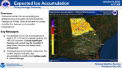
FFC is also worried about possibility for a substantial ice event.

.LONG TERM...
(Friday night through Wednesday)
Issued at 421 AM EST Thu Jan 9 2025
Precipitation will be ongoing at the start of the period late Friday
evening, though coming to a rapid end from west to east by the
predawn hours Saturday. Temperatures are expected to hover around or
just above freezing across most of north Georgia during this time.
As models have gradually trended toward a more pronounced warm nose
and warmer thermal profiles, most frozen precipitation outside of
the far north Georgia mountains will likely be in the form of
freezing rain with perhaps some lingering sleet by this time with
the bulk south of I-20 ending in only liquid rain. Additional light
ice accretion would be a concern, with total ice amounts potentially
reaching 0.2" or even higher when all is said and done. Certainly
with a trend toward a potential more pronounced freezing rain
solution, concerns for at least scattered power outages would also
increase.


