• Welcome to TalkWeather!
    We see you lurking around TalkWeather! Take the extra step and join us today to view attachments, see less ads and maybe even join the discussion.
    CLICK TO JOIN TALKWEATHER

Winter threat: 1/9-12/ 25

IMG_8843.jpeg

Jackson’s thoughts…

Thursday and Friday: A much anticipated winter storm is
continuing to come into somewhat clearer focus. As a sharp upper
trough pivots across the central CONUS, surface cyclogenesis will
ensue along the northwestern Gulf coast Thursday. The system will
track eastward along the coast into Friday, spreading precip
northward across our area late Thursday into Friday. A seemingly
consistent trend in model guidance is for later arrival of precip
on Thursday, around or after sunset in many areas. Clouds will
increase substantially earlier in the day, though temps are
expected to rise into the 40s across most of the area.

Thursday late afternoon and evening, temps will dip some with the
loss of the insolation, and with wetbulb temps in the 30s, some
additional cooling will occur at precip onset. While surface temp
advection will be quite weak, strong 850 mb warm advection will
occur overnight especially along and south of the I-20 corridor,
resulting in a growing low level warm layer aloft. Forecast low
temps are near or just above freezing over much of the southern
half and near or just below freezing over the northern half. This
should ensure a cold rain over roughly the southern third of the
area. Over the central tier, there may be enough cold air before
the warm layer aloft grows for snow or sleet at the onset of
precip, but it is very likely to transition to cold rain as the
column saturates and low level WAA increases. At this time, any
accumulations appear most likely to be negligible, but there is
still low potential for at least brief travel impacts in these
areas.

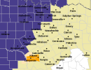
Things will be most interesting across our northern tier areas,
where it will be a bit colder at onset and a mostly subfreezing
wetbulb profile implies evap cooling potential at onset. In many of
these areas, 850 mb WAA will be weaker, resulting in thermal
profiles that are more isothermal near the freezing mark as
saturation occurs. This still leaves considerable uncertainty, as
just a few degrees will mean the difference between mostly very
cold rain, a rain/snow mix, and mostly snow. For snow accums,
lower SLRs and any p-type changes will cut in to storm totals.
It`s rather possible there will be snow/sleet accumulations that
are wiped out by a transition to rain. However, if the colder
solution prevails, this is the area with the higher ceiling for
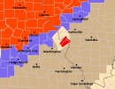
impacts from accumulating snow. As a result, the Winter Storm
Watch has been expanded to include the remainder of the US 82
corridor in our area.

Most areas may transition to rain for a period on Friday morning as
the pocket of warmer 850mb air shifts across the area. However,
with cooling during the afternoon, a transition back to snow is
possible in these areas before precip tapers off by Friday
afternoon or early evening.
 
I want snow ❄️ with no power outages. But I would prefer to avoid power outages without having rain melting the snow. And as dangerous as it is, I admit I find freezing rain a fascinating weather phenomenon, even more so when thunderstorms are involved. I know people are gonna hate me for saying that but it's true. @JPWX A couple of years back the SPC issued discussions because some of the freezing rain thunderstorms in DFW got rather strong. That led me to wonder if 1 has ever been severe.
Yes. There's been a few cases where a storm producing freezing rain became severe which prompted a Severe Thunderstorm Warning for 60mph winds. There was even one case where a storm prompted a tornado warning. I just can't remember if that was a regular precipitation storm or a mixed precipitation storm. I got a radar image of both of the above cases saved. Just need to find them.
 
That sucker’s really digging it
Baroclinic zone strengthening. Increasing temp gradient in the W GOM, but no pressure falls showing up yet. Neutral tilt trough, looking to go negative. Phasing polar and subtropical jets. The game is afoot. I like looking at models, but nothing beats watching a system evolve in real time.
 
12Z NAM is convinced it's ice. Pushes the snow way north - no snow below Cullman. No thank you.
1736347389560.png
1736347577702.png


Low tracks across LA, S MS, and S AL - not in the gulf at all. That track of the low is not what we want for sure.
 
@brianc33710

November 25th 2018 (first image): Tornado Warning right beside Winter Weather Advisory and Blizzard Warning.
November 11th 2022 (2nd image): Severe Thunderstorm Warning right beside Ice Storm Warning
 

Attachments

  • lsx tornado and blizzard warning mashup November 25th 2018.png
    lsx tornado and blizzard warning mashup November 25th 2018.png
    11 KB · Views: 0
  • fwd (November 11th 22).png
    fwd (November 11th 22).png
    12.9 KB · Views: 0
12Z NAM is convinced it's ice. Pushes the snow way north - no snow below Cullman. No thank you.
View attachment 32695
View attachment 32696


Low tracks across LA, S MS, and S AL - not in the gulf at all. That track of the low is not what we want for sure.
this would be disastrous for the i20 corridor. hopefully it’s drunk.

regardless, i think someone along the us278-us80 axis from AL into GA is getting an ice storm that’s going to be quite memorable and not for good reasons.
 
this would be disastrous for the i20 corridor. hopefully it’s drunk.

regardless, i think someone along the us278-us80 axis from AL into GA is getting an ice storm that’s going to be quite memorable and not for good reasons.
Same. It's showing up entirely too often for my comfort.
 
Spann is being awfully precise for this level of model madness. He's taking the ensemble mean and going with it I guess. Probably a safe move. Someone's going to criticize whatever the forecast is though.

"*Snow amounts of 4-6 inches are now forecast for the Tennessee Valley of North Alabama. Totals of 2-3 inches are forecast for places like Anniston and Gadsden in Northeast Alabama. Around 1-2 inches for Birmingham… Tuscaloosa could see one inch or so. Some freezing rain could create icy bridges down to the I-85 corridor for a brief time Friday morning."
 
Didn’t the NAM have an ice bias for the storm earlier this week that went through the Midwest? If I’m not mistaken it was forecasting ice a couple days out in northern KY which ended up getting hammered with snow.
Here's hoping - I'd much rather get dumped on with surprise amounts of snow. I'd be interested in seeing what the NAM thought about the KY snow for sure - I wasn't watching that one closely, I confess.
 
seems like the models are a touch warmer than they were 18-24 hours ago.

i'm in north shelby county about 10 miles southeast of downtown birmingham. there was a time there where it looked like the warm air advection would lose out and we could get a lot of ice and snow. now, i'm pretty concerned that we are all rain my mid morning.

how are temperatures yesterday and today faring compared to forecast? i am curious if the snowpack across MO/KY is being modeled correctly. would love for the models to be 3-5 degrees too warm, but i'm skeptical.

will birmingham EVER have a snow forecast where there is virtually no question about it? there's always something missing. precip outrunning cold air, warm air advection, 33 degrees, very cold but no moisture, a bad sun angle in late february or march that melts snow even when it is 20 degrees outside. just once i'd like to experience what the US72 corridor is getting... a worry free forecast where the only question is 2-3 inches or 8 inches.
 
this was first mentioned on @southern_wx and screenshot pulled from there.
Good - hope it's doing the exact same thing here. I'd love to get dumped on like Louisville did.
 
seems like the models are a touch warmer than they were 18-24 hours ago.

i'm in north shelby county about 10 miles southeast of downtown birmingham. there was a time there where it looked like the warm air advection would lose out and we could get a lot of ice and snow. now, i'm pretty concerned that we are all rain my mid morning.

how are temperatures yesterday and today faring compared to forecast? i am curious if the snowpack across MO/KY is being modeled correctly. would love for the models to be 3-5 degrees too warm, but i'm skeptical.

will birmingham EVER have a snow forecast where there is virtually no question about it? there's always something missing. precip outrunning cold air, warm air advection, 33 degrees, very cold but no moisture, a bad sun angle in late february or march that melts snow even when it is 20 degrees outside. just once i'd like to experience what the US72 corridor is getting... a worry free forecast where the only question is 2-3 inches or 8 inches.
I just don't see how this is all snow, at least for the i20 corridor and south, too warm aloft....and not just by a degree or two. I think the surprise will either be more rain vs anything else or more ice, snow seems the least likely. Low is too far north and very warm air sitting to our south.
 
I just don't see how this is all snow, at least for the i20 corridor and south, too warm aloft....and not just by a degree or two. I think the surprise will either be more rain vs anything else or more ice, snow seems the least likely. Low is too far north and very warm air sitting to our south.
Depends on the low track, but most of the recent runs definitely do track it further north than we'd want for the best chances of snow. Needs to get back in the gulf.
 
Back
Top