
Tornado warning near Monticello Arkansas. I guess every storm is popping off now
Navigation
Install the app
How to install the app on iOS
Follow along with the video below to see how to install our site as a web app on your home screen.
Note: This feature may not be available in some browsers.
More options
-
Welcome to TalkWeather! We see you lurking around TalkWeather! Take the extra step and join us today to view attachments, see less ads and maybe even join the discussion. CLICK TO JOIN TALKWEATHER
You are using an out of date browser. It may not display this or other websites correctly.
You should upgrade or use an alternative browser.
You should upgrade or use an alternative browser.
Severe Weather Threat 1/5-1/6/2025
- Thread starter ashtonlemleywx
- Start date

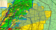
TDS near dumas (maybe)
It's a boundary-rider. Because of that, it may become long-lived.Tyro-Dumas storm looks dangerous.
View attachment 32549

AJS
Member
Mississippi storm is intensifying.
AJS
Member
Some of those isolated cells south of Rolling Fork could be concerning.
Ledian
Member
*looks at where it's possibly going long-term* Well, ain't that just reassuringIt's a boundary-rider. Because of that, it may become long-lived.

Track of the Tornado Warned storm near Rolling Fork vs. UD swath off 00z HRRR last night and 12z HRRR from earlier. The current track matches up with both UD Swaths!
Attachments
Brad Arnold has a large lowering on his stream:
 livestormchasing.com
Live Storm Chasing
Watch live feeds as storm chasers try to see if their target verifies. Tornadoes, hurricanes, blizzards, and floods - we've got it all and more, live on our site and available as video on demand.
Ledian
Member
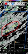
Pretty good couplet near Lake Washington
Ledian
Member
First confirmed tornado of the day is east of Marion, Louisiana
TornadoFan
Member
Tight couplet sw of Hollandale
Storm northwest of rolling fork looks dangerous. Right couplet and a bwer
Its got a relatively good debris signature on it. Even far away from radar. Maybe a strong tornado if it's lifting debris that high.First confirmed tornado of the day is east of Marion, Louisiana
*Maybe cc clutter. Its relatively convincing though
Ledian
Member
I might see a little rotation on the cell near Valley Park
CheeselandSkies
Member
Its got a relatively good debris signature on it. Even far away from radar. Maybe a strong tornado if it's lifting debris that high.
*Maybe cc clutter. Its relatively convincing though
Yeah, the radar coverage is so bad there I'm not buying it barring spotter/chaser confirmation.
Yeah, the radar coverage is so bad there I'm not buying it barring spotter/chaser confirmation.
Oak Ridge, LA, is once again under a tornado warning:
983
WFUS54 KJAN 052053
TORJAN
LAC067-123-052200-
/O.NEW.KJAN.TO.W.0004.250105T2053Z-250105T2200Z/
BULLETIN - EAS ACTIVATION REQUESTED
Tornado Warning
National Weather Service Jackson MS
253 PM CST Sun Jan 5 2025
The National Weather Service in Jackson has issued a
* Tornado Warning for...
Northern Morehouse Parish in northeastern Louisiana...
Northern West Carroll Parish in northeastern Louisiana...
* Until 400 PM CST.
* At 253 PM CST, a severe thunderstorm capable of producing a tornado
was located near Sterlington, or near Bastrop, moving east at 50
mph.
HAZARD...Tornado.
SOURCE...Radar indicated rotation.
IMPACT...Flying debris will be dangerous to those caught without
shelter. Mobile homes will be damaged or destroyed.
Damage to roofs, windows, and vehicles will occur. Tree
damage is likely.
* This dangerous storm will be near...
Mer Rouge and Bastrop around 300 PM CST.
Galion around 305 PM CST.
Bonita around 310 PM CST.
Jones around 315 PM CST.
Oak Grove around 330 PM CST.
PRECAUTIONARY/PREPAREDNESS ACTIONS...
TAKE COVER NOW! Move to a basement or an interior room on the lowest
floor of a sturdy building. Avoid windows. If you are outdoors, in a
mobile home, or in a vehicle, move to the closest substantial shelter
and protect yourself from flying debris.
&&
LAT...LON 3274 9205 3276 9206 3279 9205 3282 9207
3284 9206 3301 9161 3301 9139 3286 9134
3281 9134 3268 9196 3271 9197 3270 9202
3271 9204 3270 9204 3269 9205 3273 9207
TIME...MOT...LOC 2053Z 248DEG 44KT 3276 9203
TORNADO...RADAR INDICATED
MAX HAIL SIZE...<.75 IN
$$
SAS
warneagle
Member
speaking of places that could do without another tornado, the storm southwest of Yazoo City is starting to hook