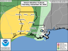
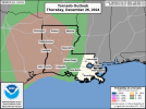
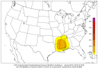
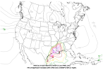
Well Thursday thru Saturday starting to look more and more interesting. At this time, looks like Thursday and Saturday are the two days where things could be more significant. CIPS analog guidance and 12z GFS/NAM CWASP valid for Saturday. SPC Day 3 Outlook has a Marginal Risk over a large portion of Central MS back into Louisiana.
SPC Day 2 Discussion: "Expect a gradual increase in convective coverage through the day as
the low-level jet intensifies ahead of the approaching wave and
greater surface based instability develops across southeast Texas.
Moderate instability and strong shear will support the potential for
supercells with an initial threat for large hail and a greater
tornado threat during the late afternoon and evening as the
low-level jet intensifies. The HRRR suggests much greater
instability and low-level shear across the warm sector Thursday
afternoon than the rest of the hi-res guidance. If this solution
were to materialize, greater tornado probabilities would likely be
warranted, but this appears to be more of an outlier solution at
this time.
Nonetheless, a favorable supercell environment will exist across
east Texas with an increasing tornado threat later in the afternoon
and evening. Any mature supercells which can develop during the
afternoon amid greater instability and remain discrete into the
evening as the low-level jet intensifies could pose a threat for a
strong (EF2+ tornado).
In addition, expect a squall line to intensify during the evening.
Instability will be relatively weak farther north, but could remain
sufficient to convectively transport the 50 to 70 knot low-level jet
to the surface across parts of southeast Oklahoma, southern
Arkansas, and northern Louisiana Thursday evening and into the
overnight hours."