
Navigation
Install the app
How to install the app on iOS
Follow along with the video below to see how to install our site as a web app on your home screen.
Note: This feature may not be available in some browsers.
More options
-
Welcome to TalkWeather! We see you lurking around TalkWeather! Take the extra step and join us today to view attachments, see less ads and maybe even join the discussion. CLICK TO JOIN TALKWEATHER
You are using an out of date browser. It may not display this or other websites correctly.
You should upgrade or use an alternative browser.
You should upgrade or use an alternative browser.
Severe Weather Threat May 7-10, 2024
- Thread starter MichelleH
- Start date
Kds86z
Member
Yeah. Lot of tornado emergencies this week to.Honestly, I’ve yet to see really bad damage out of any of the tornadoes yesterday, apart from maybe one destroyed home in Columbia, TN.
Kds86z
Member
Lot of shorter track significant tornadoes these days. Perhaps contributing to less damage and deaths
Bevo
Member
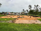
Damage from near Athens, AL, from one of last night's tornadoes.
Looks like a decently constructed house too. Hope the folks living there are okay.
Kds86z
Member
Confirmed tornado on ground Georgia
wx_guy
Member
- Messages
- 1,237
- Reaction score
- 4,443
- Location
- United States
- HAM Callsign
- KO4ZGH
- Special Affiliations
- SKYWARN® Volunteer
- ARRL Member
On visible, you can clearly see the boundary that's formed, draping across the bottom half of Louisiana and the bottom thirds of Mississippi, Alabama, and Georgia. You can see sun out below this, with convective cumulus already popping up quite abundantly. This area has dew points climbing into the 70s with CAPE exceeding 3k. Low-level lapse rates across southeast AL already over 7. It won't take much to have some explosive thunderstorms here this afternoon.


Nws is talking about a conditional derecho threat for the southeast later tonight
Kds86z
Member
Multiple tornado warnings now in GA
wx_guy
Member
- Messages
- 1,237
- Reaction score
- 4,443
- Location
- United States
- HAM Callsign
- KO4ZGH
- Special Affiliations
- SKYWARN® Volunteer
- ARRL Member
Multiple tornado warnings now in GA

Very possible. DCP values > 2 are strongly correlated with conditions ripe for derechos. This is a prime setup for it.
wx_guy
Member
- Messages
- 1,237
- Reaction score
- 4,443
- Location
- United States
- HAM Callsign
- KO4ZGH
- Special Affiliations
- SKYWARN® Volunteer
- ARRL Member
Whoops quoted the wrong reply - meant to quote Juju!! @UncleJuJu98View attachment 26977
Very possible. DCP values > 2 are strongly correlated with conditions ripe for derechos. This is a prime setup for it.
KevinH
Member
This TOR was not tweeted by NWStornado. I only saw it on IEMBotConfirmed tornado on ground Georgia
IEM :: Valid Time Event Code (VTEC) App
Iowa Environmental Mesonet of Iowa State University
wx_guy
Member
- Messages
- 1,237
- Reaction score
- 4,443
- Location
- United States
- HAM Callsign
- KO4ZGH
- Special Affiliations
- SKYWARN® Volunteer
- ARRL Member
Some more looking into a derecho possibility. I *might* have drawn the box a bit too far south, so I'll have to watch that in upcoming model runs. But from this box's sounding, I calculated the Derecho Composite Parameter and it is about 4.6, which is well above the 2 threshold to correlate to derechos. Of course, note sure what will happen, but dangerous downdrafts seem to be very possible, regardless if it qualifies as a derecho or not.

Evan
Member
Not quite as bad as I was expecting this area to look honestly. That radar signature was about as scary as it gets.
So glad to hear that the damage doesn't appear to be nearly as bad as feared. Very surprised considering the velocity couplet and TDS we saw last night.
Jpgood97
Member
Wasn’t able to see much in Columbia, TN. Every single road is blocked off way before you get to the damage. Lot of tree damage visible from Bear Creek Pike and roof damage
Evan
Member
Latest HRRR paints a potentially concerning situation with a supercell in Northern Jefferson County in Alabama around 7-8pm moving into a locally enhanced area of STP in the range of 5-7. CAPE is insane, SRH is more than sufficient, and overall shear looks potent. Very significant updraft helicity streak with said cell as it makes it way through the county moving southeast and transits through Shelby/St. Clair and then into Talladega county. The cell seems to become potent around Morris and Kimberly.
Jpgood97
Member
Elkton/Prospect in TN has a lot of tree damage, but most structures seem unharmed. I did see a carport that was blown over and bent
Yep, it's been fairly consistent with some activity over that area for several runs. Other CAMs not as supportive of this solution, but seeing as how rapidly AL is destabilizing again, wouldn't be surprised if something like that panned out. Definitely bears watching.Latest HRRR paints a potentially concerning situation with a supercell in Northern Jefferson County in Alabama around 7-8pm moving into a locally enhanced area of STP in the range of 5-7. CAPE is insane, SRH is more than sufficient, and overall shear looks potent. Very significant updraft helicity streak with said cell as it makes it way through the county moving southeast and transits through Shelby/St. Clair and then into Talladega county. The cell seems to become potent around Morris and Kimberly.
Parameters are impressive over that ar
Parameters are impressive over that area on the hrrrYep, it's been fairly consistent with some activity over that area for several runs. Other CAMs not as supportive of this solution, but seeing as how rapidly AL is destabilizing again, wouldn't be surprised if something like that panned out. Definitely bears watching.
- Admin
- #1,579
- Messages
- 2,432
- Reaction score
- 2,270
- Location
- Meridianville, Al
- Special Affiliations
- SKYWARN® Volunteer
Bama Ravens
Member
Well, if that manages to pan out, I’ll be able to give a first hand report since I’m from Morris.Latest HRRR paints a potentially concerning situation with a supercell in Northern Jefferson County in Alabama around 7-8pm moving into a locally enhanced area of STP in the range of 5-7. CAPE is insane, SRH is more than sufficient, and overall shear looks potent. Very significant updraft helicity streak with said cell as it makes it way through the county moving southeast and transits through Shelby/St. Clair and then into Talladega county. The cell seems to become potent around Morris and Kimberly.