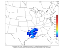
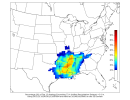
NWS JAN: "
Cyclogenesis over the central
CONUS will facilitate a consistent
moisture return with southwesterly
flow. This will lead to the rise
of
precipitable water values to 2-2.5 inches and dewpoints into the
mid-upper 60s in the area by Monday. As the main frontal
zone/
shortwave dips into the area, the environment will become
increasingly favorable for severe storm development on Monday and/or
Tuesday.
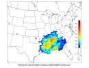
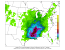
Dew points will be good, 0-6 km bulk
shear will exceed
40kts
instability will be sufficient and 500 heights will range from
574-578dm, supporting the possibility of stronger storms, some of
which may be severe. Heavy rain,
hail and damaging winds will be the
primary threats. While timing is uncertain and confidence is low
based on model variability the potential for severe weather remains.
However, at this time, we will not mention this potential in HWO
graphics. As the event approaches and more models show consistency,
there may be need for HWO graphics in the future.
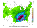
The
active weather pattern will persist through the end of next week
with multiple embedded shortwaves dipping into the area keeping rain
chances consistent. There is potential for a more significant event
to round off the week and shift the pattern by Friday/Saturday. With
the prolonged period of rain/storms
flash flood products may be
needed but is not being advertised on HWO graphics at this
time."
NWS MEG: "Mid to long range models continue to show southwest upper-level
flow aloft developing over the Lower Mississippi Valley for much
of next week. A mid-level
trough will rotate through the Upper
Midwest early next week with a weak cold
front dropping into the
region by Tuesday. This
front is expected to weaken and become
nearly
quasi-stationary across the region with the potential for
lingering shower and
thunderstorm chances through next week.
Long range
ensemble guidance indicates the potential for surface-
based
CAPE values to range between 500-800
J/kg Monday afternoon
and evening. However,
shear will only average around 25
kts for
quasi-organization as better kinematics will remain displaced over
the Upper Midwest. This may be enough to support perhaps a few
strong thunderstorms during this time frame early next week."