CheeselandSkies
Member
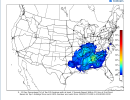
0Z run was impressive; 06Z less so although the general pattern remained consistent, which is what matters at this range.
Follow along with the video below to see how to install our site as a web app on your home screen.
Note: This feature may not be available in some browsers.
Last frame of Euro is also sticking to this general pattern. I'm interested to see 00z Euro tonight.0Z run was impressive; 06Z less so although the general pattern remained consistent, which is what matters at this range.
Yeah. Euro tonight’s 0z timeframe will be start of getting into the rangeLast frame of Euro is also sticking to this general pattern. I'm interested to see 00z Euro tonight.

.png")
.png")
.png")
Bad timing can really jank things though, seen some consistent ones in the past to just not mesh well on timing or parameters and bust high end potential. Wouldn't be surprised for. Day 7-8 outlook if we keep it up though. But these day 4-8 outlooks have flopped as of lateThe level of (esp. regarding areal coverage) GEFS agreement is pretty significant, especially for the time of year.
Absolutely, little things could nyx even a rather impressive-looking setup, especially at this range, and there's still not a lot of specific agreement, instead mostly broad. But the signals for a generally active period seem fairly solid thus far.Bad timing can really jank things though, seen some consistent ones in the past to just not mesh well on timing or parameters and bust high end potential. Wouldn't be surprised for. Day 7-8 outlook if we keep it up though. But these day 4-8 outlooks have flopped as of late
Albeit I'm off of work this day so maybe it's my luck