• Welcome to TalkWeather!
    We see you lurking around TalkWeather! Take the extra step and join us today to view attachments, see less ads and maybe even join the discussion.
    CLICK TO JOIN TALKWEATHER

Significant Tornado Events

Since the 50th anniversary of 4/3/74 is coming up and TornadoTalk is doing some articles on it I figured to try and ignite some discussion on it again. Anyways, photos.

The Parker City, Indiana F4. The 2nd photo I'm pretty sure I've seen doctored versions of somewhere:

View attachment 23111
View attachment 23112
View attachment 23113

Monroe Central School:

View attachment 23114

Depauw, Indiana. Pics of the tornado itself, it lacked a condensation funnel for most of its path, very strange looking:

View attachment 23118


View attachment 23119
View attachment 23120
View attachment 23121


View attachment 23122
View attachment 23123

The way we knew 4/27 was gonna be as bad (or worse) as advertised was when Cullman showed up on the skycam and bore a strong family resemblance to these. Wild multiple vortices, horizontal tubes, seemingly having difficulty staying fully condensed for a while due to the extreme amount of low-level shear before finally planting as a stout wedge beneath a classic, sculpted mothership mesocyclone base.
 
The way we knew 4/27 was gonna be as bad (or worse) as advertised was when Cullman showed up on the skycam and bore a strong family resemblance to these. Wild multiple vortices, horizontal tubes, seemingly having difficulty staying fully condensed for a while due to the extreme amount of low-level shear before finally planting as a stout wedge beneath a classic, sculpted mothership mesocyclone base.
Is that why Cullman took on it's weird appearance (at least the first half of it's life?). It looked almost invisible for a while before fully wedging out while near Arab.
 
Last edited:
Is that why Cullman took on it's weird appearance (at least the first half of it's life?). It looked almost invisible for a while before fulling wedging out while near Arab.

It does give the appearance that the vortex is being sheared apart until the updraft gets strong enough to overcome it. Just speculation on my part though; decades and many millions of dollars in research and there's still an awful lot we don't know about what the low-level winds do in a supercell near and during tornadogenesis.
 
It does give the appearance that the vortex is being sheared apart until the updraft gets strong enough to overcome it. Just speculation on my part though; decades and many millions of dollars in research and there's still an awful lot we don't know about what the low-level winds do in a supercell near and during tornadogenesis.
It's that due to the fast-moving storm systems on that day?
Once thing I noticed about the 4/27/11 tornadoes is many of them started off as tall, widely visible stovepipes before morphing into rain-wrapped, massive wedges with low-hanging cloud bases. Is that something with the shear again?
 
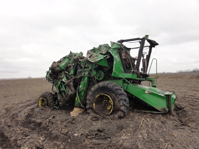
Unrelated to the current discussion but I strongly suspect the 7/26/2010 Reserve tornado was worthy of an EF4 rating and the actual strongest tornado in Montana's recorded history. The state's only official F4 (Glendive 1961) is not listed as a significant tornado by Grazulis and from what I've heard was literally a brief touchdown in an empty field. The Reserve tornado on the other hand completely destroyed the Smith Ranch at its peak intensity, sweeping away every building on the property with the exception of one quonset hut that was flattened regardless. A two-story ranch house was swept clean, and two people were killed there despite sheltering in the home's basement. In addition, a pickup truck was thrown a quarter mile, a combine was rolled "several times" per the NWS survey and left a mangled mess, and grain bins full of grain were obliterated, including one that had its foundation cracked. Though the ranch home was not well anchored, the damage seems pretty consistent with other tornadoes rated low-end EF4 including Pocahontas 2011 and Keota 2023 (the homes impacted in those cases were also not well constructed, but the contextual damage was still used to rate those tornadoes as violent including a combine wrecked in a very similar fashion by the Pocahontas County EF4).

Footage of the thing:


Screenshot_2021-05-08_Microsoft_Word_-_Sheridan_County_Tornado_Event_Summary__Final__-_sheridan2010_.png

reserve-damage-1.jpg
reserve-damage-2.png
Screenshot_2021-05-08_Microsoft_Word_-_Sheridan_County_Tornado_Event_Summary__Final__-_sheridan2010_.png


For reference, the combine in Reserve:
Screenshot_2021-05-08_Microsoft_Word_-_Sheridan_County_Tornado_Event_Summary__Final__-_sheridan2010_.png


The combine in Pocahontas (unlike Reserve this is a plowed farm field):
TORD_Pic.JPG
 
Unrelated to the current discussion but I strongly suspect the 7/26/2010 Reserve tornado was worthy of an EF4 rating and the actual strongest tornado in Montana's recorded history. The state's only official F4 (Glendive 1961) is not listed as a significant tornado by Grazulis and from what I've heard was literally a brief touchdown in an empty field. The Reserve tornado on the other hand completely destroyed the Smith Ranch at its peak intensity, sweeping away every building on the property with the exception of one quonset hut that was flattened regardless. A two-story ranch house was swept clean, and two people were killed there despite sheltering in the home's basement. In addition, a pickup truck was thrown a quarter mile, a combine was rolled "several times" per the NWS survey and left a mangled mess, and grain bins full of grain were obliterated, including one that had its foundation cracked. Though the ranch home was not well anchored, the damage seems pretty consistent with other tornadoes rated low-end EF4 including Pocahontas 2011 and Keota 2023 (the homes impacted in those cases were also not well constructed, but the contextual damage was still used to rate those tornadoes as violent including a combine wrecked in a very similar fashion by the Pocahontas County EF4).

Footage of the thing:


Screenshot_2021-05-08_Microsoft_Word_-_Sheridan_County_Tornado_Event_Summary__Final__-_sheridan2010_.png

View attachment 23057
View attachment 23058
Screenshot_2021-05-08_Microsoft_Word_-_Sheridan_County_Tornado_Event_Summary__Final__-_sheridan2010_.png


For reference, the combine in Reserve:
Screenshot_2021-05-08_Microsoft_Word_-_Sheridan_County_Tornado_Event_Summary__Final__-_sheridan2010_.png


The combine in Pocahontas (unlike Reserve this is a plowed farm field):
TORD_Pic.JPG


I've always wanted more info on this thing, great collection of pics. Yeah, I'd say this thing was at least EF4, maybe EF5 for a brief moment (definitely would get an F5 on the old scale). Always wanted to find more info on Montana tornadoes, western tornadoes in general are interesting to me.
 
Last for photos is Sayler Park, Ohio. First 2 are of the funnel itself:

Sayler 1.jpg
1974_04_03_095.jpg

Damage:

1974_04_05_001.jpg1974_04_05_002.jpg1974_04_05_015.jpg1974_04_05_21.jpg1974_04_05_021.jpg1974_04_05_045.jpg1974_05_01_29.jpgSayler 2.jpg

While the tree damage looks intense and there definitely is some debris granulation I'm not sure this would warrant EF5 today. They were definitely more lenient back then.


I've decided for other tornadoes from Indiana (Hanover, Madison & Monticello) to just link to a page that has all the photos available, as there's hundreds of pics from them. Indiana (along with Kentucky) is one of the two states that day that definitely wasn't as well documented or it's hard to find damage pics from. Perhaps TornadoTalk will change that. I think most of the Indiana tornadoes that day weren't really all that impressive.

This is an excellent site, archived but every page on it is available via the Wayback Machine. Got 200+ photos of Brandenburg damage too. Unfortunately no Alabama tornadoes from that day. But TornadoTalk will likely rectify that.


Different but this is HD footage of Andover 1991 going through McConnell AFB, while it was transitioning to multivortex. You can really see all the debris swirling around it & the BX before and after the tornado destroys it. I will never not be amazed by this video:

 
It's that due to the fast-moving storm systems on that day?
Once thing I noticed about the 4/27/11 tornadoes is many of them started off as tall, widely visible stovepipes before morphing into rain-wrapped, massive wedges with low-hanging cloud bases. Is that something with the shear again?

Again, just conjecture as this all goes far beyond my level of knowledge, but I would attribute it more to the low-level shear present than the storm speed.

Some fascinating research has been coming out recently on how subtle changes in the environment as a supercell moves through it can lead to changes in tornado size/intensity/visibility, failed occlusions, deviant motion followed by a resumption of initial motion, etc. Trey Greenwood mentions it in passing in a lot of his Convective Chronicles videos.
Interesting. And of course, the terrain tornadoes travel over can alter it's appearrance, forward, as well (especially if rugged and hilly).
I know that fast-moving supercells often prevent occlusions of tornadoes happening, which is why you see lots of very long-tracked tornadoes go through multiple narrowings before ramping back up again.
 
I've always wanted more info on this thing, great collection of pics. Yeah, I'd say this thing was at least EF4, maybe EF5 for a brief moment (definitely would get an F5 on the old scale). Always wanted to find more info on Montana tornadoes, western tornadoes in general are interesting to me.
I think Reserve would have almost certainly gotten an F5 rating had it occurred before 1970 or so. I don't think it's an EF5 candidate though. Couldn't find any notable ground scouring or a scar on satellite imagery, nor did it debark trees (though it was more than likely capable of producing at least partial debarking to hardwoods, but I don't know how many trees it encountered considering that area of Montana is extremely remote). The similarly violent 2011 Almena, KS tornado also should have been rated EF4 since it not only managed to do both but actually picked up and threw heavy farm implements a considerable distance (a quarter mile if I'm not mistaken?)

Last for photos is Sayler Park, Ohio. First 2 are of the funnel itself:

View attachment 23170
View attachment 23171

Damage:

View attachment 23172View attachment 23173View attachment 23174View attachment 23175View attachment 23176View attachment 23177View attachment 23178View attachment 23179

While the tree damage looks intense and there definitely is some debris granulation I'm not sure this would warrant EF5 today. They were definitely more lenient back then.


I've decided for other tornadoes from Indiana (Hanover, Madison & Monticello) to just link to a page that has all the photos available, as there's hundreds of pics from them. Indiana (along with Kentucky) is one of the two states that day that definitely wasn't as well documented or it's hard to find damage pics from. Perhaps TornadoTalk will change that. I think most of the Indiana tornadoes that day weren't really all that impressive.

This is an excellent site, archived but every page on it is available via the Wayback Machine. Got 200+ photos of Brandenburg damage too. Unfortunately no Alabama tornadoes from that day. But TornadoTalk will likely rectify that.


Yeah, Sayler Park and Xenia are perfect examples of tornadoes that fall in a strange category - F5 is warranted but they likely wouldn't pass EF5 muster.
(then again, EF5 ratings are basically impossible to achieve these days so they wouldn't get that rating even if they did sweep away well constructed homes.)
 
well if you would make a list of evrey tornado before 2007 that should be rated EF5 today base on the fact that villonia and mayfeild cant be rated EF5 it would be this.

  1. Marion County - Barnes F4+ July 2004
and thats the full list...
thats by following the so call NWS rules

and yes bridge creek, jarrell wouldnt even be rated EF5 today, there was one paper stating this about bridge creek 1999 is the same damage intensity as the 2 other EF4 on the same day as the el reno 2011 EF5 , as in 200 mph rating.

the 2004 marion county didnt get rated F5 because of of the only thing the F scale had that would downgrade a tornado that the EF scale didnt. and thats the whole tornado is moving slow so we can not rate it a F5 rule.

now if i would make a list of what would be rated EF5 in 2007-2013 it would be this.

  1. Xenia F5+ April 1974 (borderline)
  2. Lincoln County- Franklin County- Coffee County F4+ April 1974 (borderline)
  3. Jordan F5+ June 1976 (borderline)
  4. Niles - Hubbard - Wheatland F5 May 1985 (borderline)
  5. Haysville - Andover F5+ April 1991
  6. Jarrell F5+ May 1997 (borderline)
  7. Lawrence County April F5 1998
  8. Bridge creek - Newcastle - Moore F5+ May 1999
  9. Marion County - Barnes F4+ July 2004
it is to note that these 2007-2013 tornadoes would fit the times EF5 rating but didnt get rated EF5

  1. Hopewell - Macksville EF3+ May 2007(borderline)
  2. Flat Rock EF4+ April 2011
  3. Ringgold EF4+ April 2011
  4. Wren EF3+ April 2011
  5. Chickasha - Blanchard - Newcastle EF4+ May 2011
  6. Goldsby - Dibble EF4+ May 2011 (borderline)
 
To be completely honest I have to chalk up at least some claims of Marion County 2004's violence to internet rumor. It's constantly thrown around that it was "one of the strongest tornadoes of the 2000's, if not in general" yet I've never seen any genuine F5 structural damage with that one. I have a handful of photos from Marion and yeah, the contextual damage was something else so at the very least I can't refute that it was extremely violent.
 
and if anyone wants to know what the full list would be counting the post 2007 and pre 1950 here it is with what should most likely be there damage rating.

Pre 1950
Pomeroy F5 July 1893: 200-202 mph
Cuming County - Thurston County F5 April 1908: 200-202 mph
Tupelo F5 April 1936: 204-205 mph

1950 to before 1974
Flint - Beecher F5 June 1953: 200-202 mph

April 1974
Lincoln County- Franklin County- Coffee County F4+ April 1974: 200-202 mph
Xenia F5+ April 1974: 200-202 mph

1975-1999
Jordan F5+ June 1976: 200-202 mph
Barneveld F5 June 1984: 204-205 mph
Niles - Hubbard - Wheatland F5 May 1985: 200-202 mph
Haysville - Andover F5+ April 1991: 204-205 mph
Jarrell F5+ May 1997: 200-201 mph
Lawrence County April F5 1998: 204-205 mph
Bridge creek - Newcastle - Moore F5+ May 1999: 204-205 mph

2000-2006
Marion County - Barnes F4+ July 2004: 210-213 mph

2007 to before 2011
Greensburg EF5 May 2007: 209-210 mph
Hopewell - Macksville EF3+ May 2007: 200-202 mph
Elie F5 June 2007: 204-205 mph
Parkersburg - New Hartford EF5 May 2008: 200-201 mph

April 2011
Philadelphia EF5 April 2011: 215 mph
Wren EF3+ April 2011: 204-205 mph
Smithville - Hodges EF5 April 2011: 214-215 mph
Hackleburg - Phil campbell - Athens EF5 April 2011: 215 mph
Flat Rock EF4+ April 2011: 204-205 mph (note might get downgraded on my list)
Fyffe - Rainsville - Sylvania EF5 April 2011: 204-205 mph
Ringgold EF4+ April 2011: 204-205 mph

Post April 2011-2013
Joplin - Duquesne EF5 May 2011: 210-213 mph
El reno - Piedmont - Guthrie EF5 May 2011: 214-215 mph
Goldsby - Dibble EF4+ May 2011: 200-202 mph
Chickasha - Blanchard - Newcastle EF4+ May 2011: 204-205 mph
Newcastle - Oklahoma City - Moore EF5 May 2013: 204-205 mph

2014+
Vilonia - Mayflower EF4+ April 2014: 204-205 mph
Rochelle EF4+ April 2015: 204-205 mph
Chifeng WTS EF4 August 2017: 205-207 mph (note likely to be upgraded on my list)
Mayfield - Bremen EF4+ Dec 2021: 205-206 mph (note likely higher as im ignoring the fact some strong low shrubs might be missing with no trace)

note expect guin to be in this list once tornadotalk can just conf if that slab story is true or not
the 195 mph groups would be too long to post, i might post the full list that would be 198+ mph next
this list was made using google spreadsheets, to make it as unbias as possible for example
1705349781463.png
if i select a these 2 options... they will give the same wind speed no matter what... unlike nws who rates poorly built stuff as F5 in the past and well built swept clean as EF3 in 2007.... it means it forces them be rated fairly.
 
To be completely honest I have to chalk up at least some claims of Marion County 2004's violence to internet rumor. It's constantly thrown around that it was "one of the strongest tornadoes of the 2000's, if not in general" yet I've never seen any genuine F5 structural damage with that one. I have a handful of photos from Marion and yeah, the contextual damage was something else so at the very least I can't refute that it was extremely violent.
its so high up cause of all of this

Shrub all debark and pulled out
Well built unsure type home:Complete destruction of building with debris swept away
Safe thrown more then a mile

tornadotalk had good iamges but then they paywalled it.... its one of the only 3 things they posted they should unpaywalled, along with smithville part 1 and pampa 1995

also remember if i try to force marion county down rainsville might get the boot out of the EF5 list.
 
and if anyone wants to know what the full list would be counting the post 2007 and pre 1950 here it is with what should most likely be there damage rating.

Pre 1950
Pomeroy F5 July 1893: 200-202 mph
Cuming County - Thurston County F5 April 1908: 200-202 mph
Tupelo F5 April 1936: 204-205 mph

1950 to before 1974
Flint - Beecher F5 June 1953: 200-202 mph

April 1974
Lincoln County- Franklin County- Coffee County F4+ April 1974: 200-202 mph
Xenia F5+ April 1974: 200-202 mph

1975-1999
Jordan F5+ June 1976: 200-202 mph
Barneveld F5 June 1984: 204-205 mph
Niles - Hubbard - Wheatland F5 May 1985: 200-202 mph
Haysville - Andover F5+ April 1991: 204-205 mph
Jarrell F5+ May 1997: 200-201 mph
Lawrence County April F5 1998: 204-205 mph
Bridge creek - Newcastle - Moore F5+ May 1999: 204-205 mph

2000-2006
Marion County - Barnes F4+ July 2004: 210-213 mph

2007 to before 2011
Greensburg EF5 May 2007: 209-210 mph
Hopewell - Macksville EF3+ May 2007: 200-202 mph
Elie F5 June 2007: 204-205 mph
Parkersburg - New Hartford EF5 May 2008: 200-201 mph

April 2011
Philadelphia EF5 April 2011: 215 mph
Wren EF3+ April 2011: 204-205 mph
Smithville - Hodges EF5 April 2011: 214-215 mph
Hackleburg - Phil campbell - Athens EF5 April 2011: 215 mph
Flat Rock EF4+ April 2011: 204-205 mph (note might get downgraded on my list)
Fyffe - Rainsville - Sylvania EF5 April 2011: 204-205 mph
Ringgold EF4+ April 2011: 204-205 mph

Post April 2011-2013
Joplin - Duquesne EF5 May 2011: 210-213 mph
El reno - Piedmont - Guthrie EF5 May 2011: 214-215 mph
Goldsby - Dibble EF4+ May 2011: 200-202 mph
Chickasha - Blanchard - Newcastle EF4+ May 2011: 204-205 mph
Newcastle - Oklahoma City - Moore EF5 May 2013: 204-205 mph

2014+
Vilonia - Mayflower EF4+ April 2014: 204-205 mph
Rochelle EF4+ April 2015: 204-205 mph
Chifeng WTS EF4 August 2017: 205-207 mph (note likely to be upgraded on my list)
Mayfield - Bremen EF4+ Dec 2021: 205-206 mph (note likely higher as im ignoring the fact some strong low shrubs might be missing with no trace)

note expect guin to be in this list once tornadotalk can just conf if that slab story is true or not
the 195 mph groups would be too long to post, i might post the full list that would be 198+ mph next
this list was made using google spreadsheets, to make it as unbias as possible for example
View attachment 23420
if i select a these 2 options... they will give the same wind speed no matter what... unlike nws who rates poorly built stuff as F5 in the past and well built swept clean as EF3 in 2007.... it means it forces them be rated fairly.
as for the 198-200 mph list here it is

note that when it says 200.5+ mph it means i would be fine of having it rated EF5 but if i had to pick from 200 or 201 mph i would pick 200 mph

Pre 1950
Salix F4+ June 1899: 200 mph
Norton F4 June 1909: 200 mph

1950 to before 1974
Udall F5 May 1955: 200-200.5+
San Justo F5 Jan 1973: 200 mph

April 1974
Brandenburg F5 April 1974: 200-200.5+ mph

1975-1999
Smithfield - Birmingham F5+ April 1977: 200-200.5+ mph
Bakersfield Valley F4 June 1990: 198-200 mph

2000-2006
Harper F4+ May 2004: 200-200.5+ mph

2007 to before 2011
Trousdale EF3+ May 2007: 200 mph

April 2011
Tuscaloosa EF4+ April 2011: 200-200.5+ mph
Barnesville EF3+ April 2011: 200-200.5+ mph

Post April 2011-2013
Henryville EF4+ March 2012: 200-200.5+ mph

2014+
Louisville EF4 April 2014: 200 mph (note that the 200 mph point is a odd case, its from the only DOD on the current EF scale without a wind speed given for, it has a typical wind speed of 200 or 205 mph on the new ef scale however)
Chapman EF4+ May 2016: 200-200.5+ mph
Hope - Sartinville - Bassfield EF4 April 2020: 200 mph
Bassfield - Collins - Soso EF4 April 2020: 200-200.5+ mph

note for
  1. Sherman F5 May 1896
  2. Tri-state (Gorham - Murphysboro - West Frankfort) F5+ March 1925
  3. Cordova EF4 April 2011
  4. Holly Springs-Ashland EF4 Dec 2015
while these 4 i say for sure were EF5 in therms of would be able to and contextual evidence, however i dont think they would be rated EF5 using nws book rules, however tri-state and sherman could be put up , but both suffer form being too old, sherman i honestly think along with el reno 2011 and smithville had winds over 319+ mph
 
To be completely honest I have to chalk up at least some claims of Marion County 2004's violence to internet rumor. It's constantly thrown around that it was "one of the strongest tornadoes of the 2000's, if not in general" yet I've never seen any genuine F5 structural damage with that one. I have a handful of photos from Marion and yeah, the contextual damage was something else so at the very least I can't refute that it was extremely violent.
You've clearly never read TornadoTalk's article on it, it's easily the most violent tornado in North Dakota history.
 
note that all the ones i listed above would for sure have or had done EF5 damage if they would of hit anything that would give it a 210+ mph di
that is minus
  1. Salix F4+ June 1899
  2. Hope - Sartinville - Bassfield EF4 April 2020

these 5 would for sure have done 210+ mph di if they would of hit anything well built
  1. St. Croix County - New Richmond F5 June 1899
  2. Hudsonville - Grand Rapids F5 April 1956
  3. Guin - Delmar F5+ April 1974
  4. Loyal Valley F4+ May 1999
  5. el reno EF3+ May 2013
anything else is stuff i say wouldnt be EF5 or its info i never herd about
 
Back
Top