Add some sleet to that freezing rain with temps in the 20’s. Could be a mess. Birmingham NWS morning discussion mentions extending the advisories south to near Montgomery later today.
Going to add the NWS bmx text to this post in just a second.
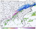
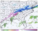
**Icy conditions can be expected every where except i85 and southward**
Key messages:
- Icy travel conditions expected for much of the area by Tuesday
morning.
- Dangerously cold temperatures and wind chills expected, especially
Tuesday night and Wednesday morning.
Southwest flow aloft continues Monday night, downstream of a
digging trough over the central CONUS and over top of an Arctic
air mass that will be advancing southeastward. A 500mb shortwave
will be lifting northeast away from the area. Some subsidence
along with mid-level drying in the dendritic growth zone (DGZ)
will result in a decrease in precipitation intensity or perhaps a
lull in the precipitation, before a 700mb speed max/weak wave
initiates an uptick in isentropic lift and associated light
precipitation overnight. Given the drying in the DGZ and the 850mb
0C isotherm remaining parked over our far northern counties until
late in the night, any snow chances will largely remain limited
to the far northern counties. But as the 925mb and surface
freezing lines advance southeastward, light rain will change over
to light freezing rain initially given the warm nose aloft and
then potentially to sleet as the near-surface air mass continues
to cool. There is some model variability in when/where the
subfreezing temperatures will be at the surface, but the general
model consensus suggests this rain-wintry mix transition zone will
move through the I-59 corridor around 9pm-midnight, and reach
just north of the I-85 corridor by Tuesday morning. With
temperatures dropping into the 20s overnight, travel will quickly
become hazardous with moisture on roadways plus the additional
light freezing rain/freezing drizzle/sleet beginning to freeze.
It takes very little freezing rain/freezing drizzle to begin to
cause travel impacts. Given that these impacts are beyond 36
hours, a winter weather advisory for the I-20 corridor/southward
towards the I-85 corridor has not been issued yet, but will
likely be issued on later shifts.
Bottom line is, icy travel conditions can be expected by Tuesday
morning everywhere except the I-85 corridor southward, and will
have to closely watch the freezing line as it approaches the I-85
corridor.