warneagle
Member
New warning now including Bowling Green; also there's apparently an Auburn, KY which I wasn't aware of.
Follow along with the video below to see how to install our site as a web app on your home screen.
Note: This feature may not be available in some browsers.
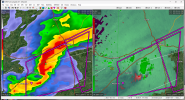
Yeah, that Camden cell is trouble.A tornado warning is needed near Camden Tennessee
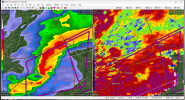
They dropped the warning on this. It's a little surprising given the clear in flow notch. Velocity not impressive though.Cell about to cross I-55 north of Como, MS/south of Memphis still tornado-warned. Edit: They might let it expire in a minute or so.
Other two discrete cells in western TN still "just" severe-warned for the time being.
The one behind it as well.Yeah, that Camden cell is trouble.
One behind it is warned now. Waiting for the Camden one as wellYeah, that Camden cell is trouble.
They dropped the warning on this. It's a little surprising given the clear in flow notch. Velocity not impressive though.Cell about to cross I-55 north of Como, MS/south of Memphis still tornado-warned. Edit: They might let it expire in a minute or so.
Other two discrete cells in western TN still "just" severe-warned for the time being.
The HRRR really fancies that cell to go offThey dropped the warning on this. It's a little surprising given the clear in flow notch. Velocity not impressive though.

Copic is chasing there and had a pretty good eye on that storm. Looked impressiveYeah, that Camden cell is trouble.
Local coverage for the Bowling Green storm.