CheeselandSkies
Member
Here it is, mid-June and I'm still pulling up Slidell and Jackson radars to track ongoing severe weather events...just like I was in February.
Follow along with the video below to see how to install our site as a web app on your home screen.
Note: This feature may not be available in some browsers.
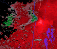
I see what you are talking about.Storm north of Jackson Mississippi is looking suspicious
SVR-warned now.I see what you are talking about.
The National Weather Service in Jackson has issued a
* Severe Thunderstorm Warning for...
Western Leake County in central Mississippi...
Northeastern Madison County in central Mississippi...
* Until 845 PM CDT.
* At 727 PM CDT, a severe thunderstorm was located near Way, or 11
miles northeast of Canton, moving east at 25 mph.
HAZARD...Ping pong ball size hail and 60 mph wind gusts.
SOURCE...Radar indicated.
IMPACT...People and animals outdoors will be injured. Expect hail
damage to roofs, siding, windows, and vehicles. Expect
wind damage to roofs, siding, and trees.
* This severe thunderstorm will be near...
Cameron around 740 PM CDT.
Camden around 745 PM CDT.
Farmhaven around 750 PM CDT.
Carthage and Redwater around 825 PM CDT.
PRECAUTIONARY/PREPAREDNESS ACTIONS...
A Tornado Watch remains in effect until 100 AM CDT for central
Mississippi.
For your protection move to an interior room on the lowest floor of a
building.
&&
LAT...LON 3263 8970 3263 8974 3268 9007 3273 9007
3274 9005 3276 9003 3283 9002 3283 9000
3284 8999 3287 8948 3259 8947
TIME...MOT...LOC 0027Z 270DEG 22KT 3275 8998
HAIL THREAT...RADAR INDICATED
MAX HAIL SIZE...1.50 IN
WIND THREAT...RADAR INDICATED
MAX WIND GUST...60 MPH
And just given a thunderstorm warningStorm north of Jackson Mississippi is looking suspicious
The National Weather Service in Jackson has issued a
* Tornado Warning for...
Southwestern Leake County in central Mississippi...
Northwestern Scott County in central Mississippi...
Northeastern Madison County in central Mississippi...
* Until 845 PM CDT.
* At 738 PM CDT, a severe thunderstorm capable of producing a tornado
was located near Sharon, or 9 miles northeast of Canton, moving
east at 20 mph.
HAZARD...Tornado and ping pong ball size hail.
SOURCE...Radar indicated rotation.
IMPACT...Flying debris will be dangerous to those caught without
shelter. Mobile homes will be damaged or destroyed.
Damage to roofs, windows, and vehicles will occur. Tree
damage is likely.
* This dangerous storm will be near...
Farmhaven around 805 PM CDT.
Ludlow around 825 PM CDT.
Lena around 840 PM CDT.
Yeah, that needs a TOR warningLooks more tornadic now.
That hook is definately there. and is now tornado warnedLooks more tornadic now.
That was quick lolThat hook is definately there. and is now tornado warned
00z JAN sounding is just absolutely unreal.
Excuse me?! But this is June not April. Seriously though OMG!VTPs up to a wicked 17 in parts of MS.
View attachment 20719
There was definitely a conditional nature to it, but I worry what kind of night we may be heading into now.SPC may come to regret not hitting the tornado threat harder for today. I think the problem was model disagreement on placement of the parameter space thanks to the earlier rounds of convection.
I'd honestly would be surprised if there's not a small 10% SIG hatch in the next Day 1 OutlookSPC may come to regret not hitting the tornado threat harder for today. I think the problem was model disagreement on placement of the parameter space thanks to the earlier rounds of convection.