
I think Tuesday is going to be the day of highest threat here and probably not the SE, more towards the Midwest. The evolution of the trough beyond Tuesday is questionable and there's likely going to be a lack of moisture, especially for a threat further southeast away from the cold temperatures aloft.
-
Welcome to TalkWeather! We see you lurking around TalkWeather! Take the extra step and join us today to view attachments, see less ads and maybe even join the discussion. CLICK TO JOIN TALKWEATHER -
 April 2024 Weather Video of the Month Post your nominations now!
You are using an out of date browser. It may not display this or other websites correctly.
You should upgrade or use an alternative browser.
You should upgrade or use an alternative browser.
Severe Threat - Feb 27-28th, 2024
- Thread starter MattPetrulli
- Start date
Justin Hindman Hindy
Member
It's going to flop around a lot between now and the event. Interesting how big the day 7 is. Right now the cape looks pretty lose however the models usually underdo it until the day of the event. I think for now the Dec, 2011 area has the best risk right now. Eastern Arky to Kentucky, Tennessee, and North Mississippi.
Mrgolfman7070
Member
Hi guys. First time posting. I am hoping we have some active weather next week here in the mid south and whatever is needed to happen will happen for a decent svr/tornado threat.
Justin Hindman
Member
- Messages
- 206
- Reaction score
- 380
- Location
- Gardendale Alabama
- Special Affiliations
- SKYWARN® Volunteer
- ARRL Member
Welcome to the forum, where are you from?Hi guys. First time posting. I am hoping we have some active weather next week here in the mid south and whatever is needed to happen will happen for a decent svr/tornado threat.
Mrgolfman7070
Member
Jackson tn currentlyWelcome to the forum, where are you from?
KevinH
Member
So you can go chasing or….?Hi guys. First time posting. I am hoping we have some active weather next week here in the mid south and whatever is needed to happen will happen for a decent svr/tornado threat.
and… welcome!
Mrgolfman7070
Member
Just want some action. BTW, my name is also Kevin lol. It's been a while since we had a high risk verify and imo, the March 31st 2023 event didn'tSo you can go chasing or….?
and… welcome!
KevinH
Member
Be careful what you wish for NAME TWIN lolJust want some action. BTW, my name is also Kevin lol. It's been a while since we had a high risk verify and imo, the March 31st 2023 event didn't
I’m in West Central GA on the AL/GA border so I watch MS/AL carefully. I like to call them the “Oklahomas of the (Deep) South” hahahaha
The next 3 months should be…… interesting.
tennessee storm chaser
Member
- Messages
- 1,123
- Reaction score
- 1,432
- Location
- jackson tennessee
- Special Affiliations
- SKYWARN® Volunteer
He is my chasing partner. actually lolSo you can go chasing or….?
and… welcome!
tennessee storm chaser
Member
- Messages
- 1,123
- Reaction score
- 1,432
- Location
- jackson tennessee
- Special Affiliations
- SKYWARN® Volunteer
The mid south and Dixie is now the new tornado alley. , haven’t you read that ?Be careful what you wish for NAME TWIN lol
I’m in West Central GA on the AL/GA border so I watch MS/AL carefully. I like to call them the “Oklahomas of the (Deep) South” hahahaha
The next 3 months should be…… interesting.
JPWX
Member
Everyone fixated on early March system and disregarding next week's storm system.
Next Week's System: Hmp! I'll show y'all!
Couple days before event: OMG! Where did this come from?
All that to say I wouldn't simply disregard the system next week due to model inconsistency.
Next Week's System: Hmp! I'll show y'all!
Couple days before event: OMG! Where did this come from?
All that to say I wouldn't simply disregard the system next week due to model inconsistency.
KevinH
Member
I have read it, I just disagree (for now).The mid south and Dixie is now the new tornado alley. , haven’t you read that ?
I still think Dixie Alley and Tornado Alley are separate. As far as I know, the definition/name of the “Alleys” is based on geographic location, not the level of tornadic activity, which is what some say their reasoning is for “moving” Tornado Alley further east.
KevinH
Member
Exactly, you would think with ALLLLL of the events that have occurred people would understand to not put all of their ego in one basket so to speak SO soon.Everyone fixated on early March system and disregarding next week's storm system.
Next Week's System: Hmp! I'll show y'all!
Couple days before event: OMG! Where did this come from?
All that to say I wouldn't simply disregard the system next week due to model inconsistency.
Why is the models having such large discrepancies still lol. Better off using ensembles right now. I'm seeing the only part of Alabama really in play for this event is extreme north Alabama, good luck to the Tennessee valley area and Midwest. Will catch them next time here in Alabama lol
Justin Hindman
Member
- Messages
- 206
- Reaction score
- 380
- Location
- Gardendale Alabama
- Special Affiliations
- SKYWARN® Volunteer
- ARRL Member
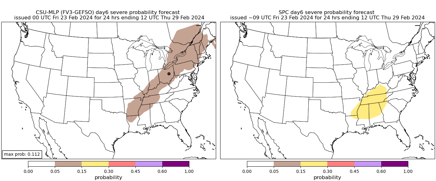
From James Spann’s blog
I know SPC is maintaining a risk of severe storms for parts of Alabama in their “Day 6” outlook for Wednesday, but at this point that scenario has no support from new model data with limited upper air support and very little surface based instability.
Spc never changes their outlooks anymore when models change lol
TheSuckZone
Member
Womp womp
pritchlaw
Member
Spann out here busting bubbles. Surely we can find some graphics to repudiate this deflating outlook!
JPWX
Member
May I present Exhibit A (6z GFS) and Exhibit B (00z Euro) temperature, dewpoint, and bulk shear.
You're welcome
You're welcome
Attachments


pritchlaw
Member
I'm sure there will be better agreement closer to the event, but for now, I am intrigued to see who was more accurate with their analysis 5 days out.
