Have at it.

-
Welcome to TalkWeather! We see you lurking around TalkWeather! Take the extra step and join us today to view attachments, see less ads and maybe even join the discussion. CLICK TO JOIN TALKWEATHER -
 April 2024 Weather Video of the Month Post your nominations now!
You are using an out of date browser. It may not display this or other websites correctly.
You should upgrade or use an alternative browser.
You should upgrade or use an alternative browser.
Severe WX Severe Threat 8/9-8/10 2023
- Thread starter StormStalker
- Start date
Kolle
Member
- Messages
- 98
- Location
- Huntsville
I listened in to the Huntsville NWS office give a briefing on tomorrow's weather this afternoon. Their consensus seemed to be this will be a high-uncertainly but also high-ceiling event, and specifically mentioned that the shear in place for tomorrow was something more often seen in Spring setups.
JPWX
Member
- Messages
- 1,602
- Location
- Smithville MS
I'll be honest. The 18z 3km NAM and the last run of the HRRR I looked at (think it was the 18z) seemed a bit lackluster on storm coverage. Having said that, the HRRR and NAM future radars haven't been doing that great.
Weatherphreak
Member
- Messages
- 352
- Location
- Huntsville
Brad Travis seems fairly concerned with tomorrow. He mentioned having to watch for supercells ahead of the line tomorrow afternoon. The threat around 1-2am may actually be worse based off what he said. Best case is the first round wipes out the atmosphere a good bit and the night time storms aren’t as bad. Lower level jet really gets going later on.
Weatherphreak
Member
- Messages
- 352
- Location
- Huntsville
JPWX
Member
- Messages
- 1,602
- Location
- Smithville MS
Very interesting.
- Messages
- 963
- Location
- Cullman, AL
Oof.
Timhsv
Member
Just ..wow...03Z THU right over Limestone County. Look at that STP of 10. This is August of coarse, but this is alarming somewhat

Clancy
Member
- Messages
- 3,154
- Location
- Macland, Georgia
Good. Lord.Just ..wow...00Z THU right over Limestone County. Look at that STP of 10. This is August of coarse, but this is alarming somewhat
View attachment 21297
JPWX
Member
- Messages
- 1,602
- Location
- Smithville MS
Good grief!Just ..wow...00Z THU right over Limestone County. Look at that STP of 10. This is August of coarse, but this is alarming somewhat
View attachment 21297
warneagle
Member
Those SRH values would be eye-popping in April, much less August
This was today's 12z CSU-MLP probability forecast for tomorrow. Sadly, the HREF hazard guidance is inoperable.

Clancy
Member
- Messages
- 3,154
- Location
- Macland, Georgia
Most of the CAMs showing some nasty looking discrete to semi-discrete convection this afternoon over northern Alabama, followed by an MCS overnight.
TheSuckZone
Member
- Messages
- 359
- Location
- Kansas
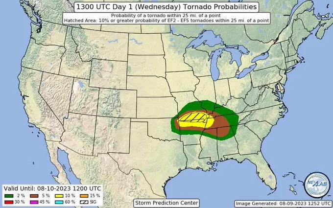
10% hatched Tornado area for latest outlook
Clancy
Member
- Messages
- 3,154
- Location
- Macland, Georgia
ENH expanded, 30% wind and hail contours in addition to the 10% tornado risk.

JPWX
Member
- Messages
- 1,602
- Location
- Smithville MS
First August 10% SIG hatch on record for that area. First 5% in August for North MS since 2012 (outside of a tropical system), and First 5% in August for North AL on record (outside of a tropical system).10% hatched Tornado area for latest outlook
warneagle
Member
I thought they gave a good explanation on why they held off on a higher risk category for the time being. Looks like a real bang-or-bust setup.
Weatherphreak
Member
- Messages
- 352
- Location
- Huntsville
Wonder if the STP is over doing it due to the high CAPE values we have this time of year? Brad mentioned in one of his streams the EHI seemed a bit over blown and said it was probably due to CAPE.Just ..wow...03Z THU right over Limestone County. Look at that STP of 10. This is August of coarse, but this is alarming somewhat
View attachment 21297
Clancy
Member
- Messages
- 3,154
- Location
- Macland, Georgia
Does seem that summer CAPE gives a big boost to the STPs, though as we've seen sometimes big CAPE can overcome lesser dynamics.Wonder if the STP is over doing it due to the high CAPE values we have this time of year? Brad mentioned in one of his streams the EHI seemed a bit over blown and said it was probably due to CAPE.
tennessee storm chaser
Member
What’s more impressive to me is the lower level wind shear later this evening for august . In this part country for sureDoes seem that summer CAPE gives a big boost to the STPs, though as we've seen sometimes big CAPE can overcome lesser dynamics.