• Welcome to TalkWeather!
    We see you lurking around TalkWeather! Take the extra step and join us today to view attachments, see less ads and maybe even join the discussion.
    CLICK TO JOIN TALKWEATHER

Volcano thread

Some eye candy from Guatemala's Fuego last night (within normal limits for its current advisory level and within the exclusion zone):


Fuego's VAAC advisories.
 
Feel free to verify what was said in the videos for yourself :)
I'd rather fact-check it with a volcanologist.

Finding patterns is useful in geology and that "Ring of Fire" meme probably did help when the boffins were first sorting out plate tectonics fifty or so years ago.

Now they have studied it in detail, and also have general volcanology to draw on. They have moved beyond that. Trust the experts, not YouTube, tabloids, and other such sources.

It's too bad that these clickbait things get so widespread -- there is true wonder in the actual facts, especially in the bottom-line fact: the huge scale on which Earth operates, both physically and over time.
 
Puracé has erupted in Colombia; per the GVP, almost 2 million people live within 70 miles of it, but its frequent eruptions are low-level effusive/explosive.

This one started with an explosion:


Also, Puracé is remote -- located within the Andean Belt Biosphere park, which looks very pretty:

 
Kamchatka's Shiveluch was heard from today and also issued an impressive pyroclastic flow (no people live that close to it, I believe):


Edit: Oops, video can't be embedded but it's worth watching. The cloud sort of reminds me of Redoubt's.

Volcano Discovery on the VAAC advisory.
 
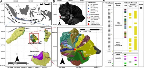
Here's a post I did on Anak Krakatau a couple of years ago, with some info and images ...


...as well a link to the webcams; these are still images and most are not that clear (the volcano sits more than 20 miles from either Java or Sumatra shores, out in the middle of the Sunda Strait). At the moment, it is hidden, and there are no new updates from Darwin:

 
Very impressive screen cap from early on:

 
More information is coming out as everybody starts a new day over there, though I think things might have quieted back down; time will tell.

This time lapse shows mostly Anak Krakatau's typical level of activity when awake; that was yesterday, then, shortly after midnight...

 
Today's Vulkane.net update. Darn it:

A couple of hours ago, from the area (Jakarta-based Norwegian, I think, photographer who got important footage related to the 2018 collapse and tsunami, which came close to him and his family that night; here he is just commenting on the still-image view of incandescence on the horizon 20-some miles away):


Three hours ago, Darwin VAAC:

FVAU04 ADRM 051230
VA ADVISORY
DTG: 20260905/1230Z
VAAC: DARWIN
VOLCANO: KRAKATAU 262000
PSN: S0606 E10525
AREA: INDONESIA
SOURCE ELEV: 155M AMSL
ADVISORY NR: 2026/177
INFO SOURCE: HIMAWARI-9 CVGHM
ERUPTION DETAILS: VA TO FL500 MOV W, VA TO FL200 MOV S TO SE
OBS VA DTG: 05/1210Z
OBS VA CLD: SFC/FL200 S0618 E10635 - S0707 E10847 - S0856
E10801 - S0934 E10510 - S0724 E10217 - S0506 E10634 MOV SE
10KT SFC/FL500 S0649 E10600 - S0914 E09907 - S1519 E09606 -
S0900 E08731 - S0257 E09628 - S0159 E10141 - S0506 E10634
MOV W 30KT
FCST VA CLD +6 HR: 05/1810Z SFC/FL200 S0455 E10701 - S0637
E10931 - S0854 E10841 - S0955 E10514 - S0743 E10144
SFC/FL500 S0621 E10548 - S0923 E09913 - S1645 E09646 - S0924
E08601 - S0313 E09407 - S0110 E09954 - S0503 E10717
FCST VA CLD +12 HR: 06/0010Z SFC/FL200 S0444 E10707 - S0644
E11009 - S0859 E10855 - S0948 E10512 - S0738 E10138
SFC/FL500 S0650 E10611 - S0958 E09920 - S1809 E09726 - S1011
E08420 - S0311 E09128 - N0005 E09913 - S0500 E10724
FCST VA CLD +18 HR: 06/0610Z SFC/FL200 S0457 E10712 - S0655
E11008 - S0907 E10859 - S0959 E10507 - S0726 E10141
SFC/FL500 S0659 E10614 - S0959 E09934 - S1916 E09843 - S1053
E08141 - S0252 E09040 - N0039 E09904 - S0458 E10719
RMK: CONTINUOUS VA TO FL500 IDENTIFIABLE ON SAT IMAGE MOV W.
CONTINUOUS VA TO FL200 MOV S TO SE. HEIGHT AND MOV BASED ON
SATELLITE IMAGERY AND FCST BASED ON DISPERSION MODELS.
NXT ADVISORY: NO LATER THAN 20260905/1430Z=
 
I say darn it because magma-water interactions during an eruption can very occasionally produce very big booms -- Hunga Tonga-Hunga Ha'apai (2022), for example, or Taupo's Hatepe (Y) eruption (third century AD) -- for reasons that I don't know that anyone in volcanology understands very well.

But the interaction seemingly has to be prolonged, as it was at HTHH and Taupo, beforehand, and there are probably many special geochemical and geophysical factors also required for such an unusual event.

Of course, Anak Krakatau has been interacting with seawater since before it first breached the surface in late 1927, and during its many collapses and comebacks, and without a problem; always in typical and gorgeous surtseyan fashion; so likely enough those special factors are not in play here. :)

Volcanologists are probably studying ash samples now to see if a new packet of magma, perhaps more gas-rich, might be responsible for this explosiveness or whether it is AK's typical magma just interacting with water.

This edifice sits right in the brink of the 1883 caldera, but it stabilized itself and began to grow early in the 20th century. It had, and probably still has, a built-in line of weakness, this layperson understands, along a particularly solid layer that developed during activity in the 1950s -- it was along this layer that AK collapsed in 2018, I believe, and it hasn't yet really grown above it yet.

Lava built the old, very impressive pre-2018 structure (seen IRL in the video below, although some of the docudrama parts are different from Simon Winchester's factual account of the 1883 catastrophe in Krakatoa).


Lava apparently is at work again (of note, 1883 eruptions produced plinian columns -- that comes from a stickier kind of magma; with that sort, the degassed stuff might flow a little bit after the big explosive show is over, but not before).
 
Two hours ago:


X translation (per a tweet from the same account a few minutes ago, this SIGMET has expired and the new one is due any time): "Update Red and Gray Volcanic Ash Zones for Anak Krakatau Child of Krakatoa as of 21:30 WIBWelcome new arrivals: Kambang, Kep. Seribu, Tangerang Raya (All), Jakarta (Soetta & Halim), Pangandaran, Patimuan, KedungrejaSIGMET Alert via InaSIAM"

WIB is central Indonesia time; the country has at least three time zones.

As far as I can tell, which isn't far, no alert level increase yet.

Meanwhile, in English, the latest GVP bulletin is to August 26th.

Update: The Java side latest SIGMET:


(After this post, I'm going to be offline all day, BTW.)
 
Yay!

Per MAGMA ID (also an official Indonesian volcanology source) (browser translation): "The continuous eruption stopped on September 6, 2026 at 00:04 WIB."

This doesn't mean the eruption is over. Badan Geology tweeted a couple of hours ago that AK had erupted again, but apparently it wasn't anything to spark a new Darwin VAAC advisory (current one is dated 0036Z on the 6th).

That actually might be really good. Total quiet after such an outburst would be worrisome, as it might mean the conduit was plugged. Volcanologists often (but not always) can see if pressure might be building because the ground and the edifice might swell -- but not at Anak Krakatau.

Its location and small size make that and other kinds of monitoring very difficult to impossible.

Maybe the Son of Krakatoa will now go back to its more typical low-level activity. Fingers crossed.

This is a nice view, tweeted earlier today:


Note the complete lack of resemblance to that incredible view of Hunga Tonga's big one on January 15, 2022.

Lava, strombolian activity, not plinian explosiveness as in 1883. I sometimes wonder what the satellite view would have been on August 27, 1883, when Krakatoa Island blew itself to smithereens. There were four big pressure waves recorded between roughly 4 and 10 a.m. at the Batavia (Jakarta) gasworks that day -- about 90 miles away. The last one went right off the paper and caused a 2½-inch mercury rise there, per Winchester's book. Wow!


X translation: "Update: The eruption of Anak Krakatau volcano has stopped around 00:00 WIB (see Himawari satellite imagery). However, the latest report from the Geological Agency indicates another eruption at 07:00 WIB. The status remains Alert Level III (avoid activities within 3 km of the volcano). The red code (danger) for aviation remains in effect.Prepare and stay alert for ashfall that is increasingly widespread in these 4 provinces: Lampung, Banten, DKI Jakarta, West Java.Continue to monitor developments in volcanic activity at volcanoes in Indonesia:"

Their alert system goes up to 5, BTW. A 4 means "get ready to go" and 5 is mandatory evacuation.

The biggest danger here, as this layperson understands it, is tsunami from a collapse (explosions could do it, too, if they occur in the right setting). It takes tsunami waves about 20-30 minutes to reach Java or Sumatra from Anak Krakatau. (Don't have the source in front of me, but it might be as much as 35 minutes.)

What happened in 2018 was that the volcano was shrouded in clouds, it was night, and the seismic signature of the collapse was not interpreted as a collapse: no one saw the waves coming until they arrived.

This time, everyone is on their toes.
 
What? Was this through a new vent? Waiting on the GVP update ...


Also volcanic lightning.
 
Looks like this is how they are monitoring for tsunami now, reportedly (browser translation):

...monitoring of 20 tsunami gauge sensors around the Sunda Strait as of 7:00 a.m. Western Indonesian Time (WIB) showed no sea level anomalies. Analysis of the High-Frequency (HF) Radar Array technology in Carita and Tanjung Lesung recorded a low tsunami probability (below 40 percent) at that time, with wave heights maintained at around one meter...
 
Back
Top