• Welcome to TalkWeather!
    We see you lurking around TalkWeather! Take the extra step and join us today to view attachments, see less ads and maybe even join the discussion.
    CLICK TO JOIN TALKWEATHER
  • Current Tropical Systems
    Erin

Tropical Storm Erin

Two of the best-performing models so far, the HCCA and the Google DeepMind AI, both have Erin turning to the WNW and NW over the next 24-36 hours, starting today. If that happens and the extent to which that happens will be huge for the ramifications further down the road.
I tell you unless my eyes are deceiving me Erin still seems to be jogging south of west. Out of curiosity do either of those models strengthen the system any over the next 24-36 hours?
 
I tell you unless my eyes are deceiving me Erin still seems to be jogging south of west. Out of curiosity do either of those models strengthen the system any over the next 24-36 hours?
Yes, it is still moving south of west right now.

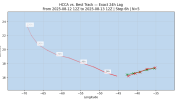
For example, here's the HCCA forecast path.

1755093897721.png


They both have a bit of strengthening over the next day, to about 55 mph or so.
 
Yes, it is still moving south of west right now.

For example, here's the HCCA forecast path.

View attachment 45976


They both have a bit of strengthening over the next day, to about 55 mph or so.

Interesting. Might have merit that it starts the west northwest turn seeing how they both have been doing quite well with the storm, but I don’t see it strengthening at all to be honest over the next 24 hours so it makes me question if the turn will occur a little bit later than expected.
 
We are getting into the window (less than 7 days out) where the models are generally more trustworthy -- still not extremely so, but more than just a blind guess. And the fact that almost all of the models have this recurving OTS gives some confidence in that. I think it's still too early to rule out any scenario, but an OTS path is looking pretty likely at this point. I'd wager currently 80% chances of OTS, and this may be conservative.
 
*crickets* Seems like excitement over Erin has totally died out lol curious to what the next few days shows. I'll post more soon.
My dumb self was wondering why the main tropical thread was quiet and didn't bother to check new threads, so that was my reason for absence!
 
Some interesting insight on Erin tonight:

1755130335187.png

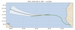
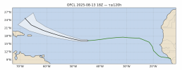
The track from Erin is at the very southern edge of the NHC Cone from 48 hours ago.


1755130458980.png

So the question arises - will Erin continue along the southern edge of the NHC cone? Could come perilously close to the islands. And it's interesting that the NHC does NOT preclude US impacts, even though almost everyone has written that possibility off. Hmmm.
 
So the question arises - will Erin continue along the southern edge of the NHC cone? Could come perilously close to the islands. And it's interesting that the NHC does NOT preclude US impacts, even though almost everyone has written that possibility off.
It’s still definitely possible, just looking much more unlikely to me at the moment. I’ve definitely jumped more onto the OTS train myself at this point, but this is definitely an interesting observation - this system is absolutely still not something to write off just yet. Also, just because it doesn’t make landfall in the US doesn’t mean it won’t be potentially dangerous for the northern side of the Lesser Antilles.

The consistency in the models is quite high on a northern turn at this point, though - I don’t see any super big reasons to completely distrust them right now. If it continues the southerly track then it’s gonna probably be bad news for somebody, at the very least.
I agree, OTS is the most likely scenario at this point.


But I will also point out this, from the latest forecast at 5 PM EDT:

FORECAST VALID 14/0600Z 16.3N 47.2W

It's just after 0z right now and by the looks of it...


1755131822052.png


... it looks like it's already lower than 16.3 N by a decent bit. Just thinking, is all.
 
Some interesting insight on Erin tonight:

View attachment 45992

The track from Erin is at the very southern edge of the NHC Cone from 48 hours ago.


View attachment 45993

So the question arises - will Erin continue along the southern edge of the NHC cone? Could come perilously close to the islands. And it's interesting that the NHC does NOT preclude US impacts, even though almost everyone has written that possibility off. Hmmm.
The western flank of that Bermuda high has trended a little bit stronger from earlier today from the Euro. If it stays on the southern end of the NHC track there’s an increase risk for the islands but also the risk it could at least slow strengthening. The fact that the NHC expected this to move WNW by now and hasn’t means the system hasn’t strengthened to the exact level the NHC expected yet.
 
18z HAFS-A and HAFS-B have Category 4 Erin nearing the Bahamas next Monday night. Definitely too close for comfort.


1755132809174.png


1755132853817.png
 
18z HAFS-A and HAFS-B have Category 4 Erin nearing the Bahamas next Monday night. Definitely too close for comfort.


View attachment 45995


View attachment 45996
Euro got me thinking about a week ago of an interesting solution (not saying this is a realistic possibility), but it kept it just offshore North Carolina but then had it turn nnw between 2 ridges with a weakness between the two and crashed into NJ. Again an extremely unlikely scenario, but then again any scenario involving the northeast would have to been seen as very unlikely with the models.
 
I almost question models now after Beryl and Milton, I hope this stays clear from the US as a whole.
I read something before the season (I don’t remember where) that there were concerns about the models going into this hurricane season. I think it was some issue with availability as far as providing ample data. I don’t remember where I read this, but I read something about concerns with models this season. I got to try and see if I can find the article.

Edit: So apparently the concern is being short on staff at the NWS. Though I don’t think that affects the models unless it affects the ability to get the best data to some degree.
 
Last edited:
I came very close to being swayed into the OTS camp today based off of earlier trends. I am still keep the non-OTS card on the table though.
 
Don't even think for a second that a US impact is off the table. Remember Florence?
I hadn’t been tracking storms in 2018 (technical first storms we Harvey and Maria in 2017 though I wasn’t truly interested in TCs yet at that time.) my first real storm was Iota in 2020.

I remember the track of Florence, kinda similar to Isabel.
 
Back
Top