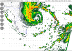
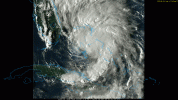
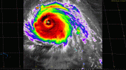
Some more thoughts - last night before I turned in I noticed a big blowup of convection on the south side of Cuba I thought was interesting.
Digging deeper into that, I think what was happening (and to some extent still is) is that dry air was being wrapped around Cuba by Imelda (09L), then mixing with moist Caribbean air causing convection, then land creates some orographic lift and it dumps over the mountains as it gets pulled back north. A Jamaican mixing bowl, if you will. Cool science to nerd out to.
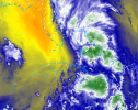
That dry air being entrained may very well be what limits Imelda's intensification moving north, assuming she ever decides to leave the Bahamas.
The amount and intensity of the convection south of Cuba is surprising me.
View attachment 46769
Digging deeper into that, I think what was happening (and to some extent still is) is that dry air was being wrapped around Cuba by Imelda (09L), then mixing with moist Caribbean air causing convection, then land creates some orographic lift and it dumps over the mountains as it gets pulled back north. A Jamaican mixing bowl, if you will. Cool science to nerd out to.

That dry air being entrained may very well be what limits Imelda's intensification moving north, assuming she ever decides to leave the Bahamas.

