Latest figures I'm seeing are 82 dead, but that will likely go up. 40 missing.Over 100 dead now.
(I'm seeing conflicting reports so hold off on taking that as gospel)
Navigation
Install the app
How to install the app on iOS
Follow along with the video below to see how to install our site as a web app on your home screen.
Note: This feature may not be available in some browsers.
More options
-
Welcome to TalkWeather! We see you lurking around TalkWeather! Take the extra step and join us today to view attachments, see less ads and maybe even join the discussion. CLICK TO JOIN TALKWEATHER
You are using an out of date browser. It may not display this or other websites correctly.
You should upgrade or use an alternative browser.
You should upgrade or use an alternative browser.
Texas Flash Flood Event July 4, 2025
- Thread starter Eoline
- Start date
Cyclonic Paracosm
Member
This statement reminds me of the Joplin event and how it formed too fast for a tor-e to get issued, remarkable event and lets hope it doesn't occur again soon.From what I've read and listen to over the last 3 days is, the NWS San Antonio would have normaly had 2 forecasters on the midnight shift, but they brought in "3" extra staff to cover the threat that was evolving, plenty of staff that night.They could have had 15 forecaster's there and still they could not have done anymore to prevent the situation that can be seen in the below graphic or would have saved anymore human lives at 4:00 A.M. in the dead of night.
Human beings can only wake up and react so fast, and this horrible, historic event occured much to fast for any human to respond properly. Sometimes horrifc tragedy happens in this world and theres really not one thing that can stop it. This is not one President's fault, a Democrat, Rebublican, or the NWS fault.It's just the fragility of humanity.All the warnings and technology in the world sometimes is just not enough to save our lives.
My heart is crushed for all the parents of those sweet little Angels that were lost. It's just too hard to comprehend it all really.May God Bless them and comfort them in the days, weeks, and years ahead.
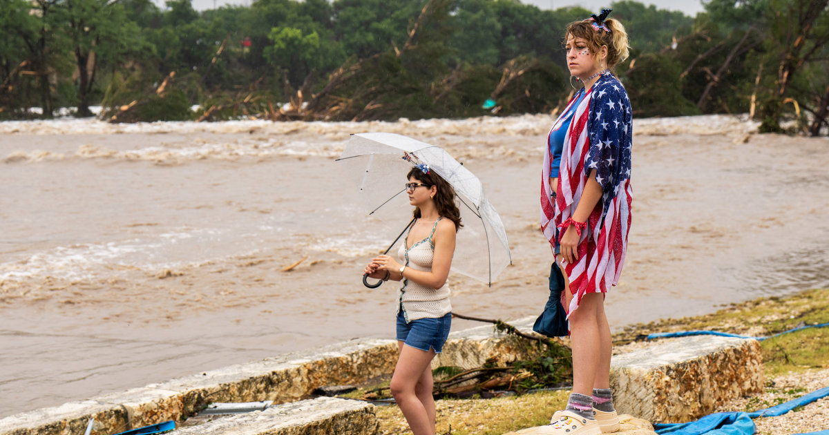
View attachment 44889
- Thread starter
- #83
Eoline
Member
Reports as of writing indicate 82, so I'm not sure where you got that number from. Could realistically surpass the 100 mark, with how many are missing after three days.Over 100 dead now.
(I'm seeing conflicting reports so hold off on taking that as gospel)
I think the article said it was expecting the total to surpass 100 due to the amount of people missing. This is where I read it fromReports as of writing indicate 82, so I'm not sure where you got that number from. Could realistically surpass the 100 mark, with how many are missing after three days.

Texas flood death set to top 100 as relatives summoned to ID bodies
Texas officials privately warned of a devastating loss of life due to the flooding in Texas Hill Country in emails shared with Daily Mail.
- Thread starter
- #85
Eoline
Member

This... cannot be happening right now.
joshoctober16
Member
View attachment 44895
This... cannot be happening right now.

around that area.
for flash flooding , the sounding would need
- EBWD: <30 knots
- 3CAPE: 20+
- MLCAPE: 1000+
- MUCAPE: 1250+
- BRN: >= 10+
- PW: 0.787+
Worst case PDS Flash flooding would be
- EBWD: <30 knots
- 3CAPE: 100+
- MLCAPE: 2100+
- MUCAPE: 2100+
- BRN: >= 45
- MLCIN: > -50
- MUCIN: > -50
- LowRH: 90+
- MidRH: 90+
- MMP: 0.6+
- K: 40+
- PW: 1.7+
the BRN right now is at 1235.2
while the K index is under 40 , the MLCAPE under 2100 , and the RH is not over 90%.
the rest is all over the threshold for the worst case disaster.
PW is over 2.1 to even 2.2 at areas right now.

joshoctober16
Member

the PW over 2+ seems to last very long in Texas and Oklahoma, for over 18+ hours
joshoctober16
Member

in the last hour one spot just had 3.6 inches of rain
and a hour ago there was a spot of 3.8 inches

joshoctober16
Member

the possible good news however is that starting tomorrow it seems like this flash flooding is over....
but im unsure about this since cells still seem to form in 24 hours

- Thread starter
- #90
Eoline
Member
Sorry, I'm a weather noob. Does this mean good or bad?around that area.
for flash flooding , the sounding would need
- EBWD: <30 knots
- 3CAPE: 20+
- MLCAPE: 1000+
- MUCAPE: 1250+
- BRN: >= 10+
- PW: 0.787+
Worst case PDS Flash flooding would be
- EBWD: <30 knots
- 3CAPE: 100+
- MLCAPE: 2100+
- MUCAPE: 2100+
- BRN: >= 45
- MLCIN: > -50
- MUCIN: > -50
- LowRH: 90+
- MidRH: 90+
- MMP: 0.6+
- K: 40+
- PW: 1.7+
the BRN right now is at 1235.2
while the K index is under 40 , the MLCAPE under 2100 , and the RH is not over 90%.
the rest is all over the threshold for the worst case disaster.
PW is over 2.1 to even 2.2 at areas right now.
Sorry, I'm a weather noob. Does this mean good or bad?
while the K index is under 40 , the MLCAPE under 2100 , and the RH is not over 90%.
the rest is all over the threshold for the worst case disaster.
N0mz
Member
When is the flooding event today supposed to start?
Cyclonic Paracosm
Member
unsure but a mdt for rainfall is again, in effect for that area..... maybe we need to add some days to this threadWhen is the flooding event today supposed to start?
Cyclonic Paracosm
Member
and NC hit 10in of rain and they also have bad flooding atm, but I don't think more rain is forecast but I could be wrong
TornadoFan
Member
104 dead now.
Muwx
Member
There are 10 deceased but unidentified children in Kerr County, and then there are still 10 campers missing. Anyone know if those 10 unidentified are the 10 missing or are there an additional 10 still actually missing? Heartbreaking either way, but if it is the latter option that could mean almost 40 deaths at Camp Mystic. Unfathomable how that camp was so unprepared for this.
84 fatalities in Kerr County alone, with a large proportion coming from the various campgrounds in the County. Search for missing continuing.

 www.pbs.org
Death toll surpasses 100 from catastrophic Texas flooding
The massive search continues for missing people.
www.pbs.org
Warnings for this event were definitely issued in time and the language properly communicated the threat for catastrophe, however it's hard to argue that if cuts hadn't lead to certain key vacancies the outcome may have been better.
So the main WFOs for this event were collectively missing a permanent science officer, a warning coordination meteorologist, a meteorologist in charge, and a senior hydrologist. I fail to see how at least 3 out of 4 of those positions couldn't have significantly contributed to a more positive outcome for this event.
Source
 www.nbcnews.com
Tom Fahy, the legislative director for the National Weather Service Employees Organization, a union that represents government employees, said the San Antonio weather forecasting office did not have two of its top positions filled — a permanent science officer (a role that conducts training and is in charge of implementing new technology) or a warning coordination meteorologist (who coordinates with the media and is the public face of the office), though there are employees acting in those leadership roles. Overall, Fahy said, the offices had enough meteorologists to respond to the event.
Fahy said the San Antonio/Austin weather forecasting office is operating with 11 staff meteorologists and is down six employees from its typical full staffing level of 26. He also said the nearby San Angelo office, whichissued warnings for parts of central Texas, is short four staff members from its usual staffing level of 23. The meteorologist-in-charge position — the office’s top leadership position — is not permanently filled. The office is also without a senior hydrologist.
“In San Angelo, there is no hydrologist, and that’s a problem,” Fahy said. Hydrologists analyze stream flow and play a key role in flood response.
So the main WFOs for this event were collectively missing a permanent science officer, a warning coordination meteorologist, a meteorologist in charge, and a senior hydrologist. I fail to see how at least 3 out of 4 of those positions couldn't have significantly contributed to a more positive outcome for this event.
Source
National Weather Service defends its flood warnings amid fresh scrutiny of Trump staff cuts
Experts said warnings issued in the run-up to this weekend’s flooding were as timely and accurate as possible, but questions about whether the alerts reached people most at risk remain.
www.nbcnews.com
That's funny because this is on about us on NWS Austin-San Antonio page.Warnings for this event were definitely issued in time and the language properly communicated the threat for catastrophe, however it's hard to argue that if cuts hadn't lead to certain key vacancies the outcome may have been better.
So the main WFOs for this event were collectively missing a permanent science officer, a warning coordination meteorologist, a meteorologist in charge, and a senior hydrologist. I fail to see how at least 3 out of 4 of those positions couldn't have significantly contributed to a more positive outcome for this event.
Source
National Weather Service defends its flood warnings amid fresh scrutiny of Trump staff cuts
Experts said warnings issued in the run-up to this weekend’s flooding were as timely and accurate as possible, but questions about whether the alerts reached people most at risk remain.