jules
Member
Sun is breaking out of the clouds in downtown Bham.
Follow along with the video below to see how to install our site as a web app on your home screen.
Note: This feature may not be available in some browsers.
Very interesting. Seems like you would have a way to put a limit on how high the values can reach. Anyways, I honestly didn't know about the different algorithms.
Aaron is on the Indiana/Ohio border near Richland. Not a good sign.Not what you want to see on the day of a potential outbreak.
It is Twitter, so you can only expect the worst takes, but yeah, I certainly won't be trusting this system to be well-behaved. Could be a very rough afternoon and evening for a lot of us.While I sincerely hope today's threat completely busts, I am worried that some people might be in for a nasty surprised based on tweets etc I have seen.
I think fundamentally, this events synoptics are the biggest strongpoints and are very impressive, reminiscent of classic, large scale outbreaks. All the largest scale classic outbreaks have synoptics to accompany them - and of course, not every impressive synoptic would then go on to produce a big outbreak... but today when it is close, I would much rather be safe than sorry.
I also think the clear cloud cover across the risk area shouldn't really come as a surprise: models have been showing a big dry punch for days now and I myself often easily fall down the "trust the CAM hole" which in my opinion is completely natural given they have been leading weather forecasting in some aspects recently - but sometimes I think its also good to take a look on a larger scale which can perhaps be a bit more illuminating of the whole picture. Moreover, As people here have already concluded - moisture return here is pretty much a given even with cloud cover issues: terrain is inducing southerly flow into the risk area and obs already show dew points of 60F+ spreading northwards. The HRRR which over forecasted cloud cover still was developing 1500-2000j/kg of CAPE. Dew points even remain high (as much as 70F!) behind the storm cluster in TN, which could be important for later on as the environment moves NE.
Even in the southern mode, the line is much less messy and clearer than models suggested (perhaps related to my earlier post which suggested models could be underestimating extent of dry air) - this is unfortunately a positive thing for the development of discrete storms from TN into KY, which could easily go tornadic as we are all aware.
With the clearing and moisture transport commencing in the northern mode, I still believe a line of discrete thunderstorms will develop there, and strengthen through the evening (even somewhat soon). I truly, truly hope to be completely wrong about all of this - but as today evolves I am getting very concerned.
Not a fan of thisSun keeps trying to come out here.

Uh, 92 mph wind gust and ‘houses destroyed’ among the storm reports with that MCS in West Virginia. Yikes!
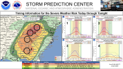
Yeah I think TN may get hammered. Any storms that move up from north west MS into the state is bad news and will likely produce tornadoes. I think they may run along the boundary that is being laid right now70/40 tornado probs on that one.
View attachment 24708
Right on cue @Clancy LOL!!!70/40 tornado probs on that one.
View attachment 24708