
Quite a bit of convection ongoing across OK and MO rn that I imagine will have a rather large impact on tomorrow's threat.
Navigation
Install the app
How to install the app on iOS
Follow along with the video below to see how to install our site as a web app on your home screen.
Note: This feature may not be available in some browsers.
More options
-
Welcome to TalkWeather! We see you lurking around TalkWeather! Take the extra step and join us today to view attachments, see less ads and maybe even join the discussion. CLICK TO JOIN TALKWEATHER
You are using an out of date browser. It may not display this or other websites correctly.
You should upgrade or use an alternative browser.
You should upgrade or use an alternative browser.
Svr Wx threat April 1-April 2 2024
- Thread starter KevinH
- Start date
tennessee storm chaser
Member
- Messages
- 1,877
- Reaction score
- 4,288
- Location
- jackson tennessee
- Special Affiliations
- SKYWARN® Volunteer
Talking bout good way or a perhaps a bad way , ? Convection hurting the instability ? Or convection setting up outflow boundaries perhaps ..Quite a bit of convection ongoing across OK and MO rn that I imagine will have a rather large impact on tomorrow's threat.
F
Former Member 1430
Guest
Where would you expect this convection to track?Quite a bit of convection ongoing across OK and MO rn that I imagine will have a rather large impact on tomorrow's threat.
NorthGaWeather
Member
CAM’s are great and can provide a good look at how the day may play out, but don’t get lost in run-to-run variations. Focus on the larger picture synoptically and how the setup should play out based on the background environment. Then work all failure modes and significant questions. I know this may be common sense to some, but I figured it should be repeated.
This setup has had high ceiling potential for a couple of days but also has a few failure modes for the northern threat areas and that hasn’t changed. The only thing that changed is that Norman went with the high ceiling forecast. It may play out or be modulated in the north. I figure it will be modulated to a degree…which is probably still a significant event.
To me, the southern threat area has a higher floor/lower ceiling with the QLCS and some semi-discrete mode.
wx_guy
Member
- Messages
- 1,237
- Reaction score
- 4,443
- Location
- United States
- HAM Callsign
- KO4ZGH
- Special Affiliations
- SKYWARN® Volunteer
- ARRL Member
Springfield MO is now under a SVR tagged as “Extremely Dangerous Situation” I’ve never seen that before. Almost like a SVR Emergency.
KCweatherboy
Member
Tornado warning just west of Springfield, MO. Hope it doesn't drop anything
Edit: warning downgraded and wx_guy beat me to it lol
Edit: warning downgraded and wx_guy beat me to it lol
Towards the Ohio River and potentially getting rid of some of the northern target.Where would you expect this convection to track?
TornadoFan
Member
Now there's an observed tornado heading towards the Springfield radar.
wx_guy
Member
- Messages
- 1,237
- Reaction score
- 4,443
- Location
- United States
- HAM Callsign
- KO4ZGH
- Special Affiliations
- SKYWARN® Volunteer
- ARRL Member
Observed tornado now moving into Springfield. Still under the EDS too.
TornadoFan
Member
02Z HRRR shows plenty of moisture back in place by 17Z tomorrow.
- Admin
- #411
- Messages
- 3,618
- Reaction score
- 3,431
- Location
- Fayetteville, AR
- Special Affiliations
- SKYWARN® Volunteer
Going to be close to the radar up that way...Observed tornado now moving into Springfield. Still under the EDS too.
wx_guy
Member
- Messages
- 1,237
- Reaction score
- 4,443
- Location
- United States
- HAM Callsign
- KO4ZGH
- Special Affiliations
- SKYWARN® Volunteer
- ARRL Member
Not sure if being so close to the radar is affecting velocity scans, but I’m seeing multiple (4-6) areas approaching Springfield with 90-110 mph velocities. Scary for sure.
Edit: Those areas went right over the radar. Hope it survived it.
Edit: Those areas went right over the radar. Hope it survived it.
Justin Hindman
Member
- Messages
- 378
- Reaction score
- 1,165
- Location
- Gardendale Alabama
- Special Affiliations
- SKYWARN® Volunteer
- ARRL Member
- Admin
- #414
- Messages
- 3,618
- Reaction score
- 3,431
- Location
- Fayetteville, AR
- Special Affiliations
- SKYWARN® Volunteer
https://traveler.modot.org/map/ live cams from MoDOT
You will need to zoom in on Springfield
Turn Traffic Cameras on (on the left menu, you may have to scroll down)
Click to view. There are quite a few in the area near the airport which appears to be the right place to be watching.

You will need to zoom in on Springfield
Turn Traffic Cameras on (on the left menu, you may have to scroll down)
Click to view. There are quite a few in the area near the airport which appears to be the right place to be watching.
TH2002
Member
- Messages
- 4,974
- Reaction score
- 11,116
- Location
- California, United States
- Special Affiliations
- SKYWARN® Volunteer
If I didn't actually need to use printers every now and then, I'd take mine straight out to the desert and happily unload a couple hundred rounds of 22LR into it... but too bad society has made printers into a necessary evil. All I'm going to say about that.I've heard IT guys (who should as a rule know what they're talking about) routinely refer to printers in very disparaging fashion (one of the more polite descriptions that I've heard is "the interesting lovechildren of Unicorns and Zebras"). Make of that what you will...
**Totally Edited By Wes**
Last edited by a moderator:
TH2002
Member
- Messages
- 4,974
- Reaction score
- 11,116
- Location
- California, United States
- Special Affiliations
- SKYWARN® Volunteer
Back to the weather, how is the threat looking for eastern West Virginia tomorrow? Definitely the beefiest threat I've seen for WV in quite some time. What effect is the ongoing convection going to have on the threat in that area?
Possible tornado on the ground near Fair Grove, MO.
Tornado Damage from Barnsdall OK
Tornado Damage from Barnsdall OK
wx_guy
Member
- Messages
- 1,237
- Reaction score
- 4,443
- Location
- United States
- HAM Callsign
- KO4ZGH
- Special Affiliations
- SKYWARN® Volunteer
- ARRL Member
Probably can’t know the finer details until 2-6 hours in advance.Back to the weather, how is the threat looking for eastern West Virginia tomorrow? Definitely the beefiest threat I've seen for WV in quite some time. What effect is the ongoing convection going to have on the threat in that area?
Justin Hindman
Member
- Messages
- 378
- Reaction score
- 1,165
- Location
- Gardendale Alabama
- Special Affiliations
- SKYWARN® Volunteer
- ARRL Member
Probably can’t know the finer details until 2-6 hours in advance.
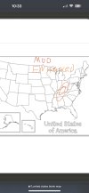
For fun here is my thoughts… Slight is yellow, enhanced is orange, and red is Moderate. Let’s see how this plays out.You ho
For fun here is my thoughts… Slight is yellow, enhanced is orange, and red is Moderate. Lets see how this plays out.
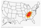
Did you google the map to