
Navigation
Install the app
How to install the app on iOS
Follow along with the video below to see how to install our site as a web app on your home screen.
Note: This feature may not be available in some browsers.
More options
-
Welcome to TalkWeather! We see you lurking around TalkWeather! Take the extra step and join us today to view attachments, see less ads and maybe even join the discussion. CLICK TO JOIN TALKWEATHER
You are using an out of date browser. It may not display this or other websites correctly.
You should upgrade or use an alternative browser.
You should upgrade or use an alternative browser.
Svr Wx threat April 1-April 2 2024
- Thread starter KevinH
- Start date


F
Former Member 1430
Guest
Well still too early to call but that was my concern earlier. I think we will know a lot by morning.Ohio. Moisture return doesn't look like it's gonna be as robust.
- Thread starter
- #344
KevinH
Member
@Clancy!!!!!…. Hush!The blue and purplish areas as highlighted on the 21Z SREF are where I'd be most concerned for tornado risk tomorrow. Shear really ramps up in the evening with intensifying low-level winds, with instability holding on well into the night; the western half of GA and much of AL ought to be on their toes tomorrow night.
View attachment 24621
lol
Tempestas Tonitrua
Member
I actually like and agree with some of the more “conservative” approaches some have taken on here concerning this event.
Crapvection is in play, and while the atmosphere can recover, moisture return, focus for convective initiation, and storm mode are still very large question marks. Eventually one of these events this year will “verify” after the slow start, I just don’t really know or think it will be this one at this junction.
Crapvection is in play, and while the atmosphere can recover, moisture return, focus for convective initiation, and storm mode are still very large question marks. Eventually one of these events this year will “verify” after the slow start, I just don’t really know or think it will be this one at this junction.
- Thread starter
- #347
KevinH
Member
Bc it’s headed to Dixie apparentlyOhio. Moisture return doesn't look like it's gonna be as robust.

Justin Hindman
Member
- Messages
- 378
- Reaction score
- 1,165
- Location
- Gardendale Alabama
- Special Affiliations
- SKYWARN® Volunteer
- ARRL Member
with all that moisture in Kentucky, it’s gonna block the stuff to the north imo
- Thread starter
- #349
KevinH
Member
Just wanted to bring this up again…. From last THURSDAY. Shout out to @ClancyCSU ML probs for D5 and D6. Pretty aggressive on those D5 probs. While I have questions about troughing, wind shear and the ultimate extent of instability, one thing is clear - moisture return will not be an issue with this setup.
View attachment 24472View attachment 24471
View attachment 24473View attachment 24474
")
CheeselandSkies
Member
Moderate risk in southern Oklahoma downgraded to Enhanced tonight
...Because the sig hail threat has peaked and, while it remains, will be less widespread in coverage. Large 10% hatched tornado area remains.
TornadoFan
Member
That aged wellJust wanted to bring this up again…. From last THURSDAY. Shout out to @Clancy
jiharris0220
Member
Lol, the 0z hrrr is now trending back towards less crapvection towards the south, allowing better moisture return.
TornadoFan
Member

Oh the woes of the HRRR. Always does something weird the night before.Lol, the 0z hrrr is now trending back towards less crapvection towards the south, allowing better moisture return.

jiharris0220
Member
Oh the woes of the HRRR. Always does something weird the night before.


Hrrr once again proving why it’s storm mode initiation is about as reliable as a farmer’s almanac.
TornadoFan
Member
We're back to the supercell printer.

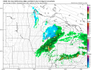
OHWX97
Member
00z HRRR depicts a nightmare scenario for the Cincinnati metro at 20-21z.

Last edited:
Tanner
Member
Honestly, in 2024 fashion, it looks the inversion is going to prevent todays tornado threat from being realized.