- Thread starter
- #1,061
KevinH
Member
SPC is late with the 9pm ET update....
Follow along with the video below to see how to install our site as a web app on your home screen.
Note: This feature may not be available in some browsers.
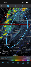
Deletedcell north of forkland AL SW of tuscaloosa starting to spin
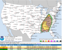
Valid 030100Z - 031200Z
...THERE IS AN ENHANCED RISK OF SEVERE THUNDERSTORMS OVER A SMALL
PART OF FAR EASTERN OH...AND ACROSS PORTIONS OF TN VALLEY AND
SOUTHEAST STATES...
...SUMMARY...
Damaging wind gusts and tornadoes remain possible from the Ohio
Valley to the Southeast tonight, particularly over a small part of
far eastern Ohio and across portions of Tennessee Valley and
Southeast States.
...01Z Update...
Multiple bands of strong to severe thunderstorms continue ahead of
an expansive cold front stretching from the IN/OH border
southwestward through central KY, western TN, northwest MS, and
central LA. Strong wind profiles will continue to support storm
organization and the potential for damaging wind gusts and/or
tornadoes with any discrete storms or embedded within any of the
numerous line segments along and/or ahead of the front.
...Middle/Upper OH Valley...
The airmass has begun to cool and stabilize ahead of the cold front
moving across the region, as evidenced by the 00Z ILN and PIT
soundings. Even so, strong ascent is spreading across the region and
thunderstorms are expected to persist along and ahead of the front
this evening. Many of the storms in this region have trended towards
a more cell-in-line/embedded supercell structure as the front
approaches. This trend will likely continue throughout the evening
and tonight. Wind fields remain very strong, as evidenced by the
recent RLX VAD profile which sampled 0-1 km bulk shear of 50 kt and
0-6 km bulk shear over 70 kt. These kinematics will likely still
support a threat for damaging gusts and embedded tornadoes
throughout the evening and tonight.
...TN Valley into the Southeast...
Thermodynamic conditions in this region are a bit more favorable
than those farther north, supported by mid 60s dewpoints reaching
into southern middle TN. Even so, poor lapse rates still limit the
overall buoyancy, with recent mesoanalysis estimating MLCAPE below
1500 J/kg across the region. General expectation is for storm
coverage to increase this evening, particularly across AL and GA.
Wind profiles remain supportive of organized storms, with damaging
gusts and tornadoes possible throughout the evening and tonight.
..Mosier.. 04/03/2024
Not yet, y'all still have some hours to go before things pass you by.Is the Chattanooga area out of the woods? I just can’t fathom anything happening here at this point based on radar trends.
Still in the 10% hatched.Is the Chattanooga area out of the woods? I just can’t fathom anything happening here at this point based on radar trends.

Didn’t know if you saw the discussion over on AmericanWX Cheese, but I thought Floydbuster asked an interesting question. Was the SPC a little too aggressive with the Moderate for Ohio as a sort of “make up call” after the miss on their part for the IN/OH event a few weeks back?Sawyerville cell needs at least a SVR. That's a pretty infamous track it's on, too. Sawyerville/north of Greensboro to Eoline/Brent-Centreville.
Otherwise, the event further north seems to be winding down, with mostly just rain showers remaining in that tiny ENH/10% TOR that SPC left to cover the ongoing warned cells. Still a warning for Muskingum County but unless it's just distance from the NEXRADs but it appears there's barely even a storm there.
Could be bugs or birds, or just noise picked up on the radar.What am I looking at in the area circled? Is this just some kind of particulate matter in the atmosphere or some kind of boundary? Those cells just to the west seem to be getting better organized.
“Was the SPC a little too aggressive with the Moderate for Ohio as a sort of “make up call” after the miss on their part for the IN/OH event a few weeks back?”Didn’t know if you saw the discussion over on AmericanWX Cheese, but I thought Floydbuster asked an interesting question. Was the SPC a little too aggressive with the Moderate for Ohio as a sort of “make up call” after the miss on their part for the IN/OH event a few weeks back?
I don’t think (not on this board) the backlash to Broyles original outlook caused them to change it. However, some of the wishcasting by some in the wx community after a rather slow start to the season sort of hyped up this event when a lot of these fail modes were staring us right in the face all week in the models for the northern area.
its located right on the riverCould be bugs or birds, or just noise picked up on the radar.
I was mainly repeating the question. However, I would caution in saying “significant” tornados until ratings are finalized by their respective NWS offices.“Was the SPC a little too aggressive with the Moderate for Ohio as a sort of “make up call” after the miss on their part for the IN/OH event a few weeks back?”
Absolutely not, that’s not how science works at all. The potential for a moderate risk was apparent, and it did at least somewhat verify with multiple significant tornadoes.
Remember that a moderate risk doesn’t mean a machine gun of violent tornadoes. The NWS made it clear this threat was on the lower end of moderate risk.
I'm not sure I've ever seen a risk area as small as that enhanced in Ohio.Last update of the day: AL/GA the main focus for strong tornado potential.