

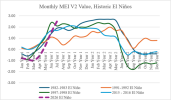
Here's a chart of the last several El Ninos. This is pretty fascinating stuff.
Follow along with the video below to see how to install our site as a web app on your home screen.
Note: This feature may not be available in some browsers.
No problem! I feel like I am the one keeping the tropical area alive, so I saw that it is a U.S. threat, so I pulled the trigger on a thread.Oh! I forgot about the TROPICAL thread. Thank you very much!
So we are already ahead of 1997-98, and we are nearly record breaking, almost outpacing the highest value from the 1982-83 event?Here's a chart of the last several El Ninos. This is pretty fascinating stuff.
View attachment 54675


This is pure speculation and conjecture, because admittedly I am not strong on teleconnections. Wouldn’t a warmer background state like @Grand Poo Bah alluded to in his great post, actually dramatically lessen the chances we get strong/historic La Niñas such as 73-74, 2011, 1956, 1917 etc?
I’m not saying La Ninas won’t exist anymore, I’m just saying that when they do occur, they’re dealing with a much warmer average state than they were in those dates I listed. Which would in turn lessen their relative strength?
Regardless of your opinions, and again this is conjecture, it does seem like there is a trend of our El Niños are stronger when they occur and our average La Ninas are weaker when they do occur.
Without sounding like a certain infamous poster, this would have some impact on tornado seasons. I don’t think it’s coincidence that some of our biggest outbreaks on record occurred during very intense/historic La Ninas.
Rising temperature baselines and ENSO (and other teleconnections) have been discussed in decent depth. The classic method for tracking ENSO, the Oceanic Niño Index (ONI), is a basic SST departure from climatology in the Niño 3.4 region. In February 2026, the CPC adopted the Relative Oceanic Niño Index (RONI), which compares the Niño 3.4 region with global tropical ocean temperatures and tracks the difference between them. The difference is then adjusted so that the historical variability matches the classic ONI measurement. Global tropical ocean temperatures provide a better indication of the ocean's baseline state and respond to climate change much more quickly. It is important to note that RONI does not simply subtract global SST warming from the classic ONI measurement. Since the tropics are still somewhat dynamic, the ONI-RONI spread can range from near zero (0.1 °C in JAS 2022 and a couple of times in 2018) to nearly 1 °C (0.8 °C in FMA-MAM 2024). See more at https://www.cpc.ncep.noaa.gov/products/analysis_monitoring/enso/roni/announcement.php.I think there’s been some substantial discussion regarding this general topic in the world of climatology. I’m not strong on it either, so take it with a grain of salt, but I recall hearing that the definition of what a La Niña/El Niño is is in the process of changing due to warmer anomalies being present in the world’s oceans in general right now. Since there’s a warmer baseline temperature to the oceans nowadays than there was just a couple decades ago, IIRC this statistically skews El Niños nowadays to be stronger than they “really are” although I do question this line of logic in a lot of ways. Again, not strong in this topic in the slightest, so I could be totally off the mark here. On the surface, I’d be inclined to believe that Niños would genuinely be stronger from SST rise, but more research is definitely needed.

This is what worries me. As of now 2018 is the closest analog to this year. The El Niño towards the latter half of the year was very very weak. It’s been eerily quiet for tornadoes quite sometime now and I think you’re going to see the 2nd season get very active because of the intensity in this El Niño. The southeast is gonna have to have their eye peels come Nov/Dec.2nd season just keeps looking more and more gnarly uuugh

From what I've picked up skimming through some of Trey's Fall/winter season forecasts (which for some reason he stopped doing), an El Nino generally correlates with less activity and less widespread activity. This is one of the papers he mentions:With how slow the past few fall seasons have been, I’ll believe it when I see it.
Yes because this El Niño will be super strong for one . Also will extend the pacific jet which wollThis is what worries me. As of now 2018 is the closest analog to this year. The El Niño towards the latter half of the year was very very weak. It’s been eerily quiet for tornadoes quite sometime now and I think you’re going to see the 2nd season get very active because of the intensity in this El Niño. The southeast is gonna have to have their eye peels come Nov/Dec.

First half of September should feature heavy rain/thunderstorms. Ensembles are a bit far out but the pattern should favor suchDon’t really put much credence into the Elnino Lanina stuff. Here in southeast Iowa our seasons have been quite consistent last few years. Frequently finding ourselves on the drought Monitor. Hardy anything you could call a winter. Increasingly high dew point Summers. Hasn’t rained my place for two weeks. The county just tore up- graded our road. Super dusty!! Heard a wet September. For the experts on this site. When exactly is the wet September to kick in ? First week of September looks to see return of heat. With active zone I-80 north in the Midwest. That is not gonna help my dust! Thanks!
Yes, around your general vicinity, it's a possibility. Can't predict this pinpoint on. Models have been abysmal. But the pattern does suggest there's a increased likelihood of SE IA receiving rain.Thanks much. But where exactly? I am in southeast Iowa. There is a hint of a wavering front. Some place across the Midwest. On top of a flat heat dome moving in from the west. Just where this zone lays out is key. Usually my experience this is along I-80. Which doesn’t help me. Or,, down in Missouri. Which doesn’t help me either. The Ring of Fire Mcs thing has recently been the only action in town. Difficult to get that thing across southeast Iowa.


