• Welcome to TalkWeather!
    We see you lurking around TalkWeather! Take the extra step and join us today to view attachments, see less ads and maybe even join the discussion.
    CLICK TO JOIN TALKWEATHER

Southeast Svr Wx threat April 8-11, 2024

KevinH

Member
Messages
2,511
Location
West Central GA
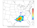
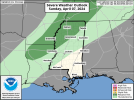
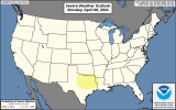
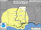
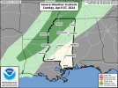
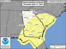
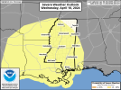
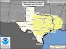
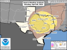
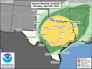
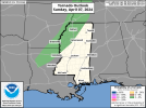
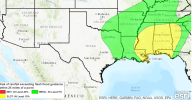
Pulling the trigger as the SPC has highlighted risk areas for April 8-9th. My own confidence is not AS high as it was for the last event, but nevertheless lol By making this thread, I am not implying anything about the magnitude of the event. I am making it to discuss the period highlighted, regardless of the severity.

Anyway… DISCUSS (nicely)….. lest @MichelleH (rightfully) reprimands you publicly :)
 
Last edited:
Pulling the trigger as the SPC has highlighted risk areas for these days. My own confidence is not AS high as it was for the last event, but nevertheless lol By making this thread, I am not implying anything about the magnitude of the event. I am making it to discuss the period highlighted, regardless of the severity.

Anyway… DISCUSS (nicely)….. lest @MichelleH (rightfully) reprimands you publicly :)
So you are saying this is gonna be a day with 3 ef5s? Lol. This is event has some potential but still a lot of questions.
 
angry betty boop GIF
 
Pulling the trigger as the SPC has highlighted risk areas for these days. My own confidence is not AS high as it was for the last event, but nevertheless lol By making this thread, I am not implying anything about the magnitude of the event. I am making it to discuss the period highlighted, regardless of the severity.

Anyway… DISCUSS (nicely)….. lest @MichelleH (rightfully) reprimands you publicly :)
Not gonna lie. You pulling the trigger on a consistent basis makes me soooooo happy. Lol.
 
While severe weather threat next week looks limited (for now) overall, we're gonna have more flash flood issues.
 

Attachments

  • precipaccum_7day_statewide.png
    precipaccum_7day_statewide.png
    1.3 MB · Views: 0
CIPS Analog on rainfall next week
 

Attachments

  • AVGPC48_gfs215F132.png
    AVGPC48_gfs215F132.png
    128.9 KB · Views: 0
  • AVGPC48_gfs215F108.png
    AVGPC48_gfs215F108.png
    130 KB · Views: 0
  • PPC48020_gfs215F132.png
    PPC48020_gfs215F132.png
    125.4 KB · Views: 0
  • PPC48020_gfs215F108.png
    PPC48020_gfs215F108.png
    125.2 KB · Views: 0
Sunday, Monday, Tuesday, and Wednesday
 

Attachments

  • MS_swody3-3.png
    MS_swody3-3.png
    335 KB · Views: 0
  • swody4_PROB.png
    swody4_PROB.png
    303 KB · Views: 0
  • swody5_PROB-1.png
    swody5_PROB-1.png
    302.8 KB · Views: 0
  • MS_swody6_PROB-5.png
    MS_swody6_PROB-5.png
    323.5 KB · Views: 0
Rainfall amounts through next Friday
 

Attachments

  • precipaccum_7day_statewide-1.png
    precipaccum_7day_statewide-1.png
    1.3 MB · Views: 0
CIPS and CSU probs picking up on possible severe potential from the 8th-10th.
severe_fcst_6panel_040612.pngPRALLC01_gfs215F120.png
 
SPC Outlooks tomorrow thru Thursday
 

Attachments

  • MS_swody2 (1).png
    MS_swody2 (1).png
    337 KB · Views: 0
  • GA_swody6_PROB.png
    GA_swody6_PROB.png
    351.7 KB · Views: 0
  • MS_swody5_PROB (1).png
    MS_swody5_PROB (1).png
    324.9 KB · Views: 0
  • TX_swody4_PROB.png
    TX_swody4_PROB.png
    336.3 KB · Views: 0
  • TX_swody3_PROB.png
    TX_swody3_PROB.png
    379.3 KB · Views: 0
  • TX_swody3.png
    TX_swody3.png
    363.3 KB · Views: 0
  • MS_swody2_TORN (1).png
    MS_swody2_TORN (1).png
    322.3 KB · Views: 0
Flash Flood/Heavy Rain threat
 

Attachments

  • wpc_qpf_168h_p.us_se.png
    wpc_qpf_168h_p.us_se.png
    401.1 KB · Views: 0
  • precipaccum_7day_statewide (3).png
    precipaccum_7day_statewide (3).png
    1.3 MB · Views: 0
  • MS_Day3.png
    MS_Day3.png
    311.6 KB · Views: 0
  • MS_Day4 (1).png
    MS_Day4 (1).png
    313 KB · Views: 0
  • Screenshot 2024-04-06 114933.png
    Screenshot 2024-04-06 114933.png
    453.1 KB · Views: 0
Back
Top