
Navigation
Install the app
How to install the app on iOS
Follow along with the video below to see how to install our site as a web app on your home screen.
Note: This feature may not be available in some browsers.
More options
-
Welcome to TalkWeather! We see you lurking around TalkWeather! Take the extra step and join us today to view attachments, see less ads and maybe even join the discussion. CLICK TO JOIN TALKWEATHER
You are using an out of date browser. It may not display this or other websites correctly.
You should upgrade or use an alternative browser.
You should upgrade or use an alternative browser.
Significant Tornado Events - Global Edition
- Thread starter atrainguy
- Start date
warneagle
Member
I do not enjoy translating Dutch because it's an extremely silly language but:Apparently there was a killer tornado in Jepara, Central Java on December 2nd, 1925View attachment 48695
Yesterday afternoon around three o'clock the district of Kaliwungu near Jepara in Kudus was damaged by a strong cyclone; around 100 native dwellings were destroyed. Three people were killed, various injuries.
The telegraph and telephone communication is broken. Countless uprooted trees block the road and the railway. The train connection to Mayong in Kudus experienced many delays.
(Later): The cyclone caused major damage to the Mayong sugar factory. Violent hailstorms over the whole district increased the misery.
Kudus (2 December) (Aneta, which was a news agency in the Dutch East Indies): The area affected by the whirlwind is 4 by 4 poles (not sure what this means?). At least 41 injuries are now known and it's possible more people were hurt. Many refuse to be treated. It turns out there is only one death. In total 167 houses were destroyed and 250 were severely damaged.
The Mayong sugar factory is lightly damaged but nine employees' homes are badly (damaged). The roofs are taken off of the reed sheds (I assume this is a type of building?). The hail that fell in Kaliwungu was the size of asem (I assume this is a kind of plant?) pits. The Assistant Resident (a colonial administrator) formed a support fund. The native leadership has acted very proactively.
Ivanthetornadoenthusiast
Member
There was also another tornado on November 1956 in Grobogan Java which killed two peopleI do not enjoy translating Dutch because it's an extremely silly language but:
Yesterday afternoon around three o'clock the district of Kaliwungu near Jepara in Kudus was damaged by a strong cyclone; around 100 native dwellings were destroyed. Three people were killed, various injuries.
The telegraph and telephone communication is broken. Countless uprooted trees block the road and the railway. The train connection to Mayong in Kudus experienced many delays.
(Later): The cyclone caused major damage to the Mayong sugar factory. Violent hailstorms over the whole district increased the misery.
Kudus (2 December) (Aneta, which was a news agency in the Dutch East Indies): The area affected by the whirlwind is 4 by 4 poles (not sure what this means?). At least 41 injuries are now known and it's possible more people were hurt. Many refuse to be treated. It turns out there is only one death. In total 167 houses were destroyed and 250 were severely damaged.
The Mayong sugar factory is lightly damaged but nine employees' homes are badly (damaged). The roofs are taken off of the reed sheds (I assume this is a type of building?). The hail that fell in Kaliwungu was the size of asem (I assume this is a kind of plant?) pits. The Assistant Resident (a colonial administrator) formed a support fund. The native leadership has acted very proactively.

warneagle
Member
Very funny to me that the word for "baby" is just "baby" like it is in German.There was also another tornado on November 1956 in Grobogan Java which killed two people
View attachment 49128
I guess this one is self explanatory, but "The (dessa?) of Menawan in the Grobogan Regency (central Java) was hit by a tornado which destroyed 16 houses and badly damaged 29 other dwellings. A mother and her baby of around 18 months (old) were killed."
Ivanthetornadoenthusiast
Member
Not gonna lie, old Dutch newspapers archive is really helpful when it comes to finding old Indonesia tornadoes information
Ivanthetornadoenthusiast
Member
On September 30th, 1991. A violent tornado (F4-F5) struck the town of Itu, Sâo Paulo, Brazil. The tornado killed 15 (or 16) and left 350 others injured. 10 of the fatalities were in a bus carrying 40 students and weighed at least 22 ton that was thrown and mangled. At the same location of the bus, an obelisk (25 meters tall and weighing at least 100 tons) was destroyed, leaving the obelisk's base badly damaged. Several other vehicles were tossed at least 200 to 300 meter.


Central Ohio Wx
Member

New IF5, and potentially the strongest structural tornado in recorded history.
WeathermanLeprechaun
Member
They've been doing a lot of work on European tornadoes recently, another tornado in the Netherlands also got upgraded i believeView attachment 49201
New IF5, and potentially the strongest structural tornado in recorded history.
jiharris0220
Member
I can definitely see the Catania tornado being up there with producing the strongest structural damage.
These are old, multi story masonry European structures with meter thick walls of solid stone.

These are old, multi story masonry European structures with meter thick walls of solid stone.
TH2002
Member
- Messages
- 4,973
- Reaction score
- 11,113
- Location
- California, United States
- Special Affiliations
- SKYWARN® Volunteer
Honestly... based on damage descriptions and that photograph, IF5 doesn't seem egregious for the 1884 Catania tornado. Regardless, I hope more damage photos become available... you can never have too many when it comes to documenting historical tornadoes.
Still think Robecco Pavese 6/16/1957 is the strongest candidate for a European F5. While the official rating still sits at F4, the ESWD entry indeed confirms an upgrade to IF5 is being considered - and imo, it's long overdue. Also, idk why Robecco Pavese and Vallescuropasso are still listed as separate tornadoes, when most Italian sources have a continuous track. Death toll is also listed as six, when contemporary newspaper reports list seven (a family of five in Cigognola and two others in Vallescuropasso).
The 1965 Torricella tornado was also extremely violent and is likely worthy of a reanalysis:
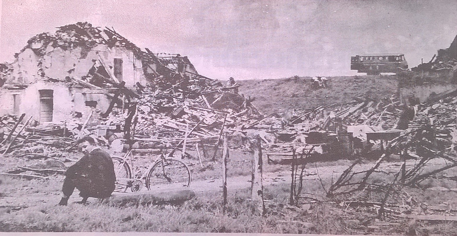
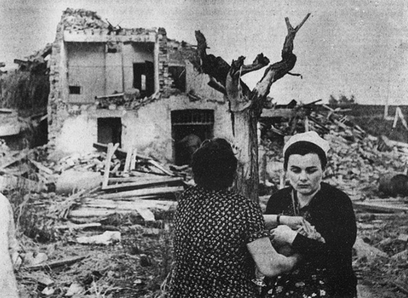

Photo of another tornado from that day, the San Giovanni tornado. Was unrated until a few months ago, when it was officially assigned an IF3 rating. Interestingly, the ESWD entry notes that it may have been stronger based on a combine harvester being lofted and "potentially even structural damage", but they stuck with IF3 due to a lack of available photos.

July 4, 1965 seems to have been a very high-end event for the region, with four tornadoes confirmed, all of them rated F3 or F4. Was likely a larger outbreak, but shorter lived and brief events in rural areas were likely lost to time. In any case, it's sad the outbreak is virtually unknown outside of Italy.
edit 2: The photo of a mangled car is from the Fiorenzuola d'Arda tornado, the deadliest of the outbreak, which killed eight and was recently rated IF3 by the ESWD. I have 100% confirmed the other two photos are from Torricella.
Still think Robecco Pavese 6/16/1957 is the strongest candidate for a European F5. While the official rating still sits at F4, the ESWD entry indeed confirms an upgrade to IF5 is being considered - and imo, it's long overdue. Also, idk why Robecco Pavese and Vallescuropasso are still listed as separate tornadoes, when most Italian sources have a continuous track. Death toll is also listed as six, when contemporary newspaper reports list seven (a family of five in Cigognola and two others in Vallescuropasso).
The 1965 Torricella tornado was also extremely violent and is likely worthy of a reanalysis:
Photo of another tornado from that day, the San Giovanni tornado. Was unrated until a few months ago, when it was officially assigned an IF3 rating. Interestingly, the ESWD entry notes that it may have been stronger based on a combine harvester being lofted and "potentially even structural damage", but they stuck with IF3 due to a lack of available photos.
July 4, 1965 seems to have been a very high-end event for the region, with four tornadoes confirmed, all of them rated F3 or F4. Was likely a larger outbreak, but shorter lived and brief events in rural areas were likely lost to time. In any case, it's sad the outbreak is virtually unknown outside of Italy.
edit 2: The photo of a mangled car is from the Fiorenzuola d'Arda tornado, the deadliest of the outbreak, which killed eight and was recently rated IF3 by the ESWD. I have 100% confirmed the other two photos are from Torricella.
Last edited:
Ivanthetornadoenthusiast
Member
As far as i know, this picture isn't actually from Torricella F4+ but rather from a separate tornado from the outbreak
Ivanthetornadoenthusiast
Member
Specifically the only photographed tornado was the San Giovanni di Ostellato tornado which killed 1 and injuring 59 others
TH2002
Member
- Messages
- 4,973
- Reaction score
- 11,113
- Location
- California, United States
- Special Affiliations
- SKYWARN® Volunteer
As far as i know, this picture isn't actually from Torricella F4+ but rather from a separate tornado from the outbreak
Corrected, thanks.Specifically the only photographed tornado was the San Giovanni di Ostellato tornado which killed 1 and injuring 59 others
Ivanthetornadoenthusiast
Member
This is probably the Fiorenzuola d'Arda (Piacenza Province) tornado which killing five people in a stretch of highway due to its rain wrapped (?) nature
GrenadinesDes
Member
NWS, whenever they finish with tornado surveying, they upload their data onto the Damage Assessment toolkit, will yall do something similar to Guarapuava and Rio Bonito after you're done evaluating them? (Also how close are yall to finishing?)We will eventually share the material, but we just need to analyze it first. It was a mixture of Araucarias and other native trees such as Ingazeiro, Araçá, and Canela, which are all hardwood. The Araucarias are a particular type of pine tree native to that area that behaves as a hardwood tree; one peculiar thing is that they will often lose their crowns under strong wind gusts to reduce the area under wind drag to survive, which often works as the only thing left standing is their trunk. However, some century-old araucarias had their trunks snapped after losing their crown, or were severely debarked. Their bark is exceptionally hard and can be as thick as 15 mm. So, we have a lot of contextual damage to look at, and the wind engineers will also help with that.
TH2002
Member
- Messages
- 4,973
- Reaction score
- 11,113
- Location
- California, United States
- Special Affiliations
- SKYWARN® Volunteer
ESWD lists eight fatalities, but you're correct, the photo is from Fiorenzuola d'Arda. I'll update the post again.This is probably the Fiorenzuola d'Arda (Piacenza Province) tornado which killing five people in a stretch of highway due to its rain wrapped (?) nature
If you notice more than one error in a post, mentioning them in a single response instead of splitting them up across multiple would be greatly appreciated next time, but thanks again for the corrections.
Ivanthetornadoenthusiast
Member
You're welcomeESWD lists eight fatalities, but you're correct, the photo is from Fiorenzuola d'Arda. I'll update the post again.
If you notice more than one error in a post, mentioning them in a single response instead of splitting them up across multiple would be greatly appreciated next time, but thanks again for the corrections.
Seems there was another one on 24 November in a remote section of national park near Gympie, Qld:I've put together a collection of visible tornado tracks that I (or other people) have found in Australia
(tried to upload a seperate image but it wasn't having it)
And another barely perceptable one from last year:
Edit: and another, apparently from 30 Jan 2016 at -35.587000, 148.518000 near Yarrangobilly
Last edited:
Tokai.Ryu
Member
Not "These", This structure was purely a two story villa that had greater than a meter thick wall, very heavy timber joists, with floors having strong connections and were made of tile roofs, and this structure specifically was heavily damaged, despite it having inconceivable levels of construction, with its walls overturned onto the streets in compact masses of several cubic meters in volume.I can definitely see the Catania tornado being up there with producing the strongest structural damage.
These are old, multi story masonry European structures with meter thick walls of solid stone.
View attachment 49202
Here's some of the damages Catania has done, I mainly used damiano macaluso's survey for it.
Various descriptions by Damiano Macaluso's Survey (approved by numerous academics, and even by ESWD and ESSL, link is: https://www.uni-met.it/trombedaria/documents/1884_Macaluso.pdf )
- A garden between Civali and Borgo had the topsoil removed revealing a volcanic lava layer below
- Multiple stone and/or brick homes with walls up to 1 meter thick partially and/or entirely destroyed, with their marble slabs being displaced as well, all of which had very heavy timber joists, with floors having strong connections and were made of tile roofs, these homes were two story.
- A two story villa with inconceivable levels of construction and had walls greater than 1 meter was completely leveled, with its walls overturned onto the streets in compact masses of several cubic meters in volume.
- Laid brick roads scoured or lifted away.
- Orange, Lemon and Olive trees snapped at the base or twisted, some lofted extreme distances.
TornadoesUK
Member
The 1957 Val Scuropasso, Italy tornado has been upgraded to IF5.