GrenadinesDes
Member
Before and After of the mansion and nearby forest, note that the line of trees in the immediate vicinity of the home was completely decimated
Follow along with the video below to see how to install our site as a web app on your home screen.
Note: This feature may not be available in some browsers.


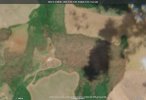
Back wall was standing, and front was made of double layered tempered glass doors with very sturdy concrete columns. Some of the glass exploded as the tornado approached and may have led to the roof failure. Still, we are analyzing all house components separetaly as we went there and collected a lot of media. The tree damage downwind of the mansion was the worst of the entire track. The grove was leveled and worst debark ocurred there. We are analyzing these very colesely as well.Reluctantly bringing this here from the other thread - @souda (I think that works?) I went with highest-end F4 with the mansion itself; while it was exceptionally well-built the public photos and satellite we do have do not indicate whether the back wall is standing. The trees behind it tell a different story:
View attachment 49059
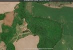
This wasn't leaked or anything, I found this on accident a few days ago while doing overlays. I could easily see a contextual upgrade to F5. Y'all probably have more photos in your possession that are understandably private, but from an amateur's perspective I could see the F5 rating coming to fruition. Also, speaking of Auracacia trees:
View attachment 49060View attachment 49061
This grove was absolutely eviscerated. The trees on the right edge of the second photo are Eucalyptus iirc.
As for Rio I think high-end F4 is fine unless the below damage is tornadic, which I'm not sure whether it is:
View attachment 49063View attachment 49065View attachment 49062
The grove is untouched on October 23 imagery from Sentinel-2.
I’m assuming the trees behind the mansion were Aucaracia (I butchered that)? I tried to find them on Streetview and the only time they are visible is on a dirt road a considerable distance west; it’s impossible to make out the tree type.Back wall was standing, and front was made of double layered tempered glass doors with very sturdy concrete columns. Some of the glass exploded as the tornado approached and may have led to the roof failure. Still, we are analyzing all house components separetaly as we went there and collected a lot of media. The tree damage downwind of the mansion was the worst of the entire track. The grove was leveled and worst debark ocurred there. We are analyzing these very colesely as well.
We will eventually share the material, but we just need to analyze it first. It was a mixture of Araucarias and other native trees such as Ingazeiro, Araçá, and Canela, which are all hardwood. The Araucarias are a particular type of pine tree native to that area that behaves as a hardwood tree; one peculiar thing is that they will often lose their crowns under strong wind gusts to reduce the area under wind drag to survive, which often works as the only thing left standing is their trunk. However, some century-old araucarias had their trunks snapped after losing their crown, or were severely debarked. Their bark is exceptionally hard and can be as thick as 15 mm. So, we have a lot of contextual damage to look at, and the wind engineers will also help with that.I’m assuming the trees behind the mansion were Aucaracia (I butchered that)? I tried to find them on Streetview and the only time they are visible is on a dirt road a considerable distance west; it’s impossible to make out the tree type.
I understand not being able to share everything thanks to SIMEPAR, so that’s enough prodding from me.
Without going into too much detail, what was one of the most well constructed building from Rio Bonito? Doesn't have to be the peak damageWe will eventually share the material, but we just need to analyze it first. It was a mixture of Araucarias and other native trees such as Ingazeiro, Araçá, and Canela, which are all hardwood. The Araucarias are a particular type of pine tree native to that area that behaves as a hardwood tree; one peculiar thing is that they will often lose their crowns under strong wind gusts to reduce the area under wind drag to survive, which often works as the only thing left standing is their trunk. However, some century-old araucarias had their trunks snapped after losing their crown, or were severely debarked. Their bark is exceptionally hard and can be as thick as 15 mm. So, we have a lot of contextual damage to look at, and the wind engineers will also help with that.
The chuch had very thick concrete columns with rebars. The part hit by the core got levelled.Without going into too much detail, what was one of the most well constructed building from Rio Bonito? Doesn't have to be the peak damage


Those are pretty impressive damage, especially the church. What are the chances they're being evaluated for a possible higher end rating? (might be prodding too much here)The chuch had very thick concrete columns with rebars. The part hit by the core got levelled. View attachment 49082View attachment 49083View attachment 49084View attachment 49085
The school was 100 m downwind and had sections that were almost completely leveled. It also had thick brick + concrete walls and additional concrete columns with rebars. Here the most estreme tree damage also happened, with trees completely defoliated and or reduced to their trunks while also debarked.View attachment 49086View attachment 49087
We are evaluating, but F4 remains thus far. There are a handful of places that deserve more analysis,Those are pretty impressive damage, especially the church. What are the chances they're being evaluated for a possible higher end rating? (might be prodding too much here)
It's been refered to as an F5 since 1988, but in 2013 MetSul directly stated it was an F5.In the midst of what i would consider a perhaps historic outbreak aftermath and surveys for Brazil and other surrounding areas, i would like to bring attention to the Encarnacion, Paraguay tornado. This was essentially a Joplin-eque tornado that took place in September 1926, and killed over 100+ people. I keep seeing people refer to this tornado as F5 and apparently, a few papers officially refer to it as a F5 which I'll try find more on. This seems to get overshadowed as one of the more catastrophic tornado events in history but it was a very horrific event. I remember this being assumed as a F4, did it get upgraded recently or has it been clarified as a F5 for a bit? If so, it's a very interesting upgrade..
Appreciate the clarification. I do wonder if the death toll would be the same nowadays, with slightly advanced warning systems and major effort made to give more light to significant tornadoes in South America.It's been refered to as an F5 since 1988, but in 2013 MetSul directly stated it was an F5.
It got upgraded recently and flew under the radar. There some other violent tornadoes in South America that are thought to have achieved F5 strength:In the midst of what i would consider a perhaps historic outbreak aftermath and surveys for Brazil and other surrounding areas, i would like to bring attention to the Encarnacion, Paraguay tornado. This was essentially a Joplin-eque tornado that took place in September 1926, and killed over 100+ people. I keep seeing people refer to this tornado as F5 and apparently, a few papers officially refer to it as a F5 which I'll try find more on. This seems to get overshadowed as one of the more catastrophic tornado events in history but it was a very horrific event. I remember this being assumed as a F4, did it get upgraded recently or has it been clarified as a F5 for a bit? If so, it's a very interesting upgrade..


It got upgraded recently and flew under the radar. There some other violent tornadoes in South America that are thought to have achieved F5 strength:
1 - Palmas (Brazil - 08/13/1959) - There just a few pictures of the aftermath of this tornado. It leveled the entire farmstead of Fazenda Fortaleza, killing 35 of its inhabitants in process. No picture exist of that particular location, but a small locomotive was thrown 50 m. A tuxedo with the documents of one of the victims was found 70 km away. Extreme tree damage also occurred with large hardwood tree reduced to their stumps. Never got rated.
View attachment 49104
2 - Ciudad de Americas (Argentina - 12/11/1979): officially rated F4 although especualtion exhists that it may have been F5. It swept away houses near the lake and removed 1" plumbing iron pipes of one of them, eventually impaling it 10 cm deep into a tree
View attachment 49099
3 - Estacion Lopez (Argentina - 05/06/1992): The aftermath of this tornado was way better documented. Officially rated as F4, but the damage it did to the small village was very high end. It leveled brick and concrete buildings with walls as thick 40 cm.
View attachment 49100View attachment 49101
4 - San Pedro (Argentina - 09/07/2009): This tornado was confined to the forested areas of Misiones. Still, it killed 11 and the state of the victims was comparable as that of what aws observed in Jarrell. It leveled forests leaving a remarkable scar visible on environmental satellite, with large hardwood trees being launched with their root balls still attached, as well intense debarking and defoliation and scouring of the grass. It also launched a pickup truck a considerable distance, removing its engine in the process never to be found.
View attachment 49102View attachment 49103
Yeah, South America has a lot of untouched material. I just saw another video if Estacion Lopez mentioned that a semi truck loaded with grain was lofted and thrown against grain silos.Thank you for the brilliant writeup! I have only heard of San Pedro which was extremely intense and the 1959 outbreak which was very significant as a whole too. The rest i haven't heard of and will have to check out in the future!

The tornado actually started just west of Lagos Seca where it damaged a gas stations, and went further east as well.View attachment 49118
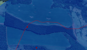
Still looking into the mansion, which is the second F4 indicator on the map.
I have the Rio tornado ending in that area while occluding north; satellite doesnt do a good job separating the two.The tornado actually started just west of Lagos Seca where it damaged a gas stations, and went further east as well.
Rio Bonito ended earlier, and Candoi-Guarapuava estarted over Lagoa Seca.I have the Rio tornado ending in that area while occluding north; satellite doesnt do a good job separating the two.