• Welcome to TalkWeather!
    We see you lurking around TalkWeather! Take the extra step and join us today to view attachments, see less ads and maybe even join the discussion.
    CLICK TO JOIN TALKWEATHER

Significant Tornado Events - Global Edition

Higher quality shot of the T6/IF3 home:
1699289851432-png.21978


Also, question: are you aware of any footage of this tornado? I know it struck after dark, so there isn't much to be found.


Only video I'm aware of is the on in the tweet above.

1730425931419.png

Here is the accompanying radar data. The fact this data has been released publicly and the fact there is a classic supercell with a V-notch and debris ball are both incredibly rare for the UK.

https://rmets.onlinelibrary.wiley.c...?domain=p2p_domain&token=WQ22XSSXTUCXBDDAECN2
 
There exists footage captured inside a house that shows the wind intensifying quickly before the video cuts off. It was reported on the TORRO Forum, so I'm uncertain if I can share it, but I'm sure I saw the video on X.
 
Some notes about the house:
All exterior walls were made with masonry bricks with cement reinforcement both externally and internally. Besides the bathroom walls, all interior walls that divided the rooms were made with wood.
What I find interesting about this event is the house having the external edges made with what seemed like some reinforced cement.
View attachment 12129
View attachment 12130

Video source of the images above:

Good to see that much of my material made it here lol.
I surveyed the damage in Tangara, as well as the small sections upstream into Ibicare and Treze Tilias. The most severe damage I found was just to the west of the city of Tangara, were this house was leveled. However, the residence indeed had a weak interior. Morever, the small pickup that was in the garage was unmoved so I could not the give a higher rating. However, I was not able to survey the entire damage track as it was too massive, but I saw damage to vegetation near that house that is commonly seen in violent torandoes, so it may have attained EF4 intensity.
 

Attachments

  • IMG-20200816-WA0072.jpeg
    IMG-20200816-WA0072.jpeg
    1.3 MB · Views: 0
  • IMG-20200816-WA0137.jpeg
    IMG-20200816-WA0137.jpeg
    1.4 MB · Views: 0
New information about the spanish supercell. Basing in what AEMET, ( the national meteorological agency says), this supercell produced at least seven tornadoes, and could have been more.
 

Attachments

  • Screenshot_20241106-221351.png
    Screenshot_20241106-221351.png
    175.4 KB · Views: 0
  • Screenshot_20241106-221351.png
    Screenshot_20241106-221351.png
    102 KB · Views: 0
I wish we had visual confirmations of past tornadoes in the Iberian Peninsula as well. Although we have recorded F-3 and few F-4 tornadoes, (one in Mallorca and another in Cadiz), we still do not have images as we have seen any of them. In Portugal as well, there are hardly any visual records. Nordic tornadoes have not been photographed many times either, the same with certain areas of Eastern Europe. Most probably, the small population of these areas makes them go unnoticed.
 
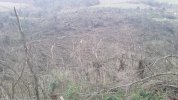
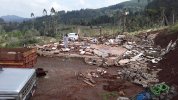
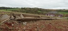
On the afternoon of July 12th, a major meteorological event unfolded in the northwestern region of Rio Grande do Sul, Brazil. A powerful wedge tornado, with a width greater than its height, tore through the region, leaving a trail of destruction in its wake. The tornado was completely enveloped in rain, making it difficult to spot and adding to its destructive power.

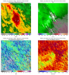
The tornado was surprisingly large, with a diameter of at least 1.5 kilometers at some points, and there is speculation that it could have been even wider. This makes it one of the largest tornadoes ever recorded in South America. Preliminary assessments suggest that the tornado was at the high end of the EF-2 scale, with winds nearing 217 km/h.


The city of Sede Nova was directly hit by the tornado, which also passed just over a kilometer north of the center of Campo Novo. In Sede Nova, twenty-five people were injured, a surprisingly small number considering the scale of the tornado and the fact that there were no human fatalities. However, many animals, including birds, were found among the debris, indicating a significant loss of animal life.


The tornado was part of a larger weather event that included a powerful cyclone that hit the South and Southeast regions of Rio Grande do Sul, causing an intensification of synoptic winds. Weather stations recorded gusts ranging between 50 and 110 km/h in this area. The cyclone also drove a strong continental polar air mass, resulting in a sharp decline in temperatures across Central-South Brazil.


The storm chaser Maycon Zanata was in the region at the time of the tornado but had to move away due to the dangerous conditions. Upon returning, he confirmed the presence of typical and characteristic tornado damage. With the help of the environmental satellite, meteorologists from Prevots will be able to confirm the occurrence, intensity, and path of this event.


The accurate forecast made by Prevots, Conexão Geoclima, and VaiChovê highlights the importance of detailed meteorological work, which uses both technical and popular terms, with warnings and forecasts that highlighted the moments of greatest risks.

The area most affected by the tornado was in the level 3 risk area in Prevots' morning forecast on the day of the occurrence. Despite the damage caused by the event, the low rate of fatalities is due to the joint work of the agencies and pages that carry out serious meteorology work in Brazil, warning the population about the dangers.

As normality is restored, videos of the tornado may emerge, allowing a better understanding of its magnitude. This event underscores the power of nature and the importance of meteorological science in predicting and understanding such phenomena.

I was the lead forecaster at PREVOTS on that day and we where expecting an impactful events days in advance. The environment as a whole was reminiscent of 11-12 June 2018 tornadoes. I guided Maycon to that area in NW Rio Grande do Sul and he was right that supercell's path. However, when the tornado touched down it was heavily wrapped in rain and he could not see it, so I told to gtfo. Latter we started to receive the reports of what happened and he was instrumental for the damage survey. After one year, we were able to rate it (we are all graduate students working voluntarely) and most of damage was of F1/F2 intensity. However, there were pockets of significant intensification near Sede Nova where concrete utility poles were snapped with the iron beams twisted, and debarked and defoliation of hardwood trees. We assigned an F3 classification as we could not find any higher DIs for constructions. Moreover it is the longest tracked tornado in Brazil with 76 km path length, and also the widest with 2.5 km.
 

Attachments

  • 20230712_182405.png
    20230712_182405.png
    2.3 MB · Views: 0
  • WhatsApp Image 2023-07-14 at 17.43.45 (1).jpeg
    WhatsApp Image 2023-07-14 at 17.43.45 (1).jpeg
    197.4 KB · Views: 0
  • WhatsApp Image 2023-07-14 at 17.43.50 (1).jpeg
    WhatsApp Image 2023-07-14 at 17.43.50 (1).jpeg
    224.1 KB · Views: 0
I wish we had visual confirmations of past tornadoes in the Iberian Peninsula as well. Although we have recorded F-3 and few F-4 tornadoes, (one in Mallorca and another in Cadiz), we still do not have images as we have seen any of them. In Portugal as well, there are hardly any visual records. Nordic tornadoes have not been photographed many times either, the same with certain areas of Eastern Europe. Most probably, the small population of these areas makes them go unnoticed.
There were TWO F4s? I only saw one (Cadiz) on Tornado Archive
 
There were TWO F4s? I only saw one (Cadiz) on Tornado Archive
Officially there has only been the F4 from Cádiz, but I am completely sure that we have had at least one other F-4.
Extract from the Menorca tornado of 1835:
"The night of October 24 to 25, a fearsome hurricane ravaged the island of Menorca without mercy.
Entering from the northwest of the island, it began its destructive path in Ciutadella. It knocked down several brick houses, uprooted several trees, and some were cut down to the level of mere stumps. When the hurricane passed through the church, it knocked down the dome and the outer walls, severely deforming the brick structure of the inner walls. The hurricane continued its destructive path through the forests in the interior of the island. Rows of ancient and sturdy oak forests were wiped off the earth, as if they had never existed. After the destruction of the forest, the soil was also taken away, for where there used to be fertile grassy land, now there was worn and bare soil. We lose the hurricane trail after L'Algar. Several residents of the municipality claim to have seen the hurricane continue through the sea. Over land, we know of a 40-kilometer journey. The hurricane's destruction reached a radius of over a kilometer and a half in some places, attesting to its extreme violence
".
Another important tornado happened on eastern Spain between 1800 -1900, in Mahora.
"On July 20th, a powerful storm formed between the towns of Jara and Quintanar del Rey, unleashing stones larger than hen's eggs, with some weighing up to 800 grams. (0,8kg). Between the towns of Mahora and Madrigueras, a whirlwind formed that, in its short life of 3 kilometers, left no vineyard unscathed. Approximately 1500 pines have been uprooted, many twisted and splintered down to the ground, quite a few stripped of bark and devoid of their outer layer. A farm worker saw the whirlwind coming, and foolishly took refuge under a blanket. The blanket flew away, but the man was lifted into the air and thrown into a pine forest approximately 200 meters away. Miraculously, he managed to survive, but the debris and pebbles that struck him along the way caused various contusions, injuring him severely".
 
Last edited:
Además, hay una cadena montañosa en España que literalmente se llama "Sierra del Rayo".
Aquí es donde desde 1960 se han producido la mayoría de tornados F3. Parece que esta zona es muy favorable para la formación de tornados fuertes y severos. También aquí hay evidencia de varias tormentas de granizo de +10 cm.
 

Attachments

  • Screenshot_20241201-125856.png
    Screenshot_20241201-125856.png
    296.2 KB · Views: 0
  • Screenshot_20241201-125908.png
    Screenshot_20241201-125908.png
    1.1 MB · Views: 0
  • Screenshot_20241201-125921.png
    Screenshot_20241201-125921.png
    748.6 KB · Views: 0
  • Screenshot_20241201-130059.png
    Screenshot_20241201-130059.png
    1.4 MB · Views: 0
  • Screenshot_20241201-125939.png
    Screenshot_20241201-125939.png
    391.9 KB · Views: 0
Last edited:
Back
Top