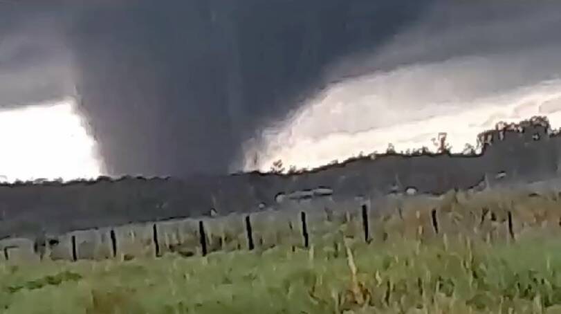
• Welcome to TalkWeather!
    We see you lurking around TalkWeather! Take the extra step and join us today to view attachments, see less ads and maybe even join the discussion.
    CLICK TO JOIN TALKWEATHER
  • April 2024 Weather Video of the Month
    Post your nominations now!
Logo 468x120

Significant Tornado Events - Global Edition

TH2002

Member
Sustaining Member
Messages
3,489
Reaction score
5,605
Location
California, United States
Special Affiliations
  1. SKYWARN® Volunteer
No reports of damage so far per Paraguayan news articles
That didn't last long. Now seeing reports of severe damage and injuries in the Mbocayaty del Yhaguy area, including at least one brick(?) home with multiple walls down - potentially F2-F3 damage here.
 
Messages
23
Reaction score
29
Location
Madrid
El 29 de agosto de 2020, una supercélula HP grave dañó significativamente varias localidades del norte de la isla de Mallorca.

Una supercélula inusualmente longeva (8 horas de vida), produjo granizo de un tamaño que oscilaba entre 6 y 9 centímetros, una ráfaga que produjo ráfagas de viento que oscilaron entre 170 y 195 km/hy varios tornados, el más intenso fue una cuña de diámetro mayor a 1 km que generó daños EF-2 de gama media y alta.

Al tratarse de una supercélula HP, la cascada de precipitaciones y granizo envolvió a los tornados, volviéndolos invisibles y peligrosos.

[ADJUNTAR=completo]21907[/ADJUNTAR]
[ADJUNTAR=completo]21908[/ADJUNTAR]
[ADJUNTAR=completo]21909[/ADJUNTAR]
[ADJUNTAR=completo]21917[/ADJUNTAR]
[ADJUNTAR=completo]21918[/ADJUNTAR]
La estructura de la supercélula.
Referring to the violent supercell of Mallorca, highlight the downburst that produced wind gusts greater than 180km/h and generated significant damage.
Screenshot_20231029-092042~2.png
Screenshot_20231029-092057~2.png
Screenshot_20231029-091926~2.png
A woman took a photo of the tornado 10 minutes before the impact.
118455176_314148953129227_4057543755128561437_n.jpg
118651814_1391597737704773_7577883134024114237_n.jpg
 
Messages
23
Reaction score
29
Location
Madrid
On July 6, 2023, an outbreak of severe supercells that produced strong winds and large hail, ended up producing several tornadoes.
Among all these cells, a monstrous one stood out that produced winds exceeding 110km/h in several observatories, hail measuring 11 centimeters and a confirmed tornado.
F0bDjgzX0AACuXb~2.jpeg
F0bDXVfX0AA9Byu.jpeg
The monster tornadic supercell.
F0aD6luaQAE9K79.jpeg
Hail reached 11 cm.
20231021191653395-compressed.jpg
The tornado produced by the supercell, It looks strong and relatively wide.
65067legaire-txikituta2.jpg
ala-hayas-kEUB-U60293774304SLH-624x385@El Correo~2.jpg
Severe damage happened through the woods when the tornado rushed into.
23_06.jpg
Localitie before the impact.
08_07.jpg
Localitie after the impact, tornado damage path was clearly visible.
 

Jacob

Member
Messages
1,299
Reaction score
850
Location
Roy, UT
Absolute unit of a tornado. This region truly is the tornado alley of the southern hemisphere. It just is less consistent. But when it flares up, it can produce some of the strongest tornadoes on earth.

I have looked at South American weather for all of about 5 minutes in my life, so on the surface this is fascinating to me, given how far north Paraguay is. The country is anywhere from about 1400 to 1800 miles south of the equator. For reference, central Cuba to just north of Miami is about 1400-1800 miles north of the equator.
 

gregassagraf

Member
Messages
119
Reaction score
188
Location
Brazil
I have looked at South American weather for all of about 5 minutes in my life, so on the surface this is fascinating to me, given how far north Paraguay is. The country is anywhere from about 1400 to 1800 miles south of the equator. For reference, central Cuba to just north of Miami is about 1400-1800 miles north of the equator.
Well… the region is influenced by two massive geographic features: the Andes mountains (longest mountain range in the world), and the Amazon rainforest. Not only that but there are plenty of deserts in Argentina, Bolivia and Chile to provide the dry air mixture, although, according to Victor Geode, dry lines are not as prevalent in the region as in North America. This setup is enough to power massive storms, from the Brazilian highlands to Argentinian’s Pampas.

I’ve seen people make the analogy of the tornado setup in southern Brazil and Paraguay to Dixie alley (high lands) and Uruguay and Argentina to traditional tornado alley (Pampas). And the analogy is not that far off. Tornadoes upper north tends to be from storm with lower cloud base and wrapped in rain. As you south, storms tend to have higher bases and tornadoes have that wizard of oz look.

In terms of forecasting, it has been a challenge. The region desperately needs more research done to produce models tailored for the environment. For example, back in August, international models were pointing to critical setup for storms in Rio Grande do Sul state, Brazil, with hodohraphs not that different from those associated with violent tornadoes in North America. It ended up being a nothing burger. Yesterday’s setup looked like other severe weather events, but ended up overproducing.

As a summary, the region is a less consistent tornado alley, with supercells being quite common through winter and spring. Massive storms will more often than not produce tornadoes, but research is needed to study and forecast this phenomena in the region. Fortunately, the death rate for these storms is quite low, for a myriad of reasons that still need to be discussed in the scientific community. Finally, I expect the number of tornadoes reported in this region to be severely underestimated. The adoption of a system like NWS there would be accompanied by a massive increase in number of reported tornadoes.

Below a video by the Brazilian storm chaser Maycon Zanata that exemplifies the kind of storms that can happen in this environment.


TH2002

Member
Sustaining Member
Messages
3,489
Reaction score
5,605
Location
California, United States
Special Affiliations
  1. SKYWARN® Volunteer
Yikes. Damage in Mbocayaty del Yhaguy looks potentially violent. In addition, a fatality was confirmed from the tornado.
Y2I35ZW3KBF5VB2JSMPTYGUSSM.jpg

QNC4IOHESJCF5DMDVXXEVRLAPQ.jpg

UXFHKQPHT5BL7J5UJY62ZV655Y.jpg

VVYWRRXS7JCDZNHCT6663KOEW4.jpg

5JAA2S2DMBETBOJLVFYO2SV5K4.jpg
 

UK_EF4

Member
Messages
573
Reaction score
1,329
Location
NW London
Pretty interesting and unusual event occurred yesterday in the Channel Islands to the S of the UK last night. A very deep Atlantic low (around 950mb) with pressure gradient related gusts in excess of 100-110mph was moving through the English Channel. Unexpectedly, a line of supercells developed ahead of the centre of the low.

One of these supercells actually struck the islands of Jersey, with very impressive structure on radar especially for NW European standards. Doppler radar even picked up a small velocity couplet:

xx_flexradar-en-340-0-zz_20231101_2355_809__fr-vsweep-1km-fala.png

1698955218018.png

Initially very large hail reports started to come in. Unusual not only for the location, but the time of the year and the environment!

Then, reports started to come in of a tornado. Video here attached with some of the damage. Most of it is shingle/tile damage though some footage starting to come in of brick walls and buildings demolished, cars moved and upper levels of buildings destroyed. Run of the mill strong tornado for the US though in these parts this strength of tornado is much rarer.
1698955419758.png1698955441563.png
1698955466525.png
1698955511268.png
Even hints the trees have been stripped of branches of leaves and vegetation, something almost never seen in the British Isles.
1698955577665.png

Likely going to be rated T5 on the TORRO scale, which would be the highest 'T-rated' tornado since 2006. Its possible the background winds of 50-70mph the time this occurred aided in some of the tornado's strength, though this does make one of the better candidates for an intense tornado in this region for a long time.


gregassagraf

Member
Messages
119
Reaction score
188
Location
Brazil
Pretty interesting and unusual event occurred yesterday in the Channel Islands to the S of the UK last night. A very deep Atlantic low (around 950mb) with pressure gradient related gusts in excess of 100-110mph was moving through the English Channel. Unexpectedly, a line of supercells developed ahead of the centre of the low.

One of these supercells actually struck the islands of Jersey, with very impressive structure on radar especially for NW European standards. Doppler radar even picked up a small velocity couplet:

View attachment 21966

View attachment 21967

Initially very large hail reports started to come in. Unusual not only for the location, but the time of the year and the environment!

Then, reports started to come in of a tornado. Video here attached with some of the damage. Most of it is shingle/tile damage though some footage starting to come in of brick walls and buildings demolished, cars moved and upper levels of buildings destroyed. Run of the mill strong tornado for the US though in these parts this strength of tornado is much rarer.
View attachment 21968View attachment 21969
View attachment 21970
View attachment 21971
Even hints the trees have been stripped of branches of leaves and vegetation, something almost never seen in the British Isles.
View attachment 21972

Likely going to be rated T5 on the TORRO scale, which would be the highest 'T-rated' tornado since 2006. Its possible the background winds of 50-70mph the time this occurred aided in some of the tornado's strength, though this does make one of the better candidates for an intense tornado in this region for a long time.


Is this a contender for most intense damage ever caused by a tornado in the UK?
 
Top