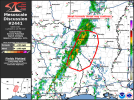
Probability of Watch Issuance...20 percent
SUMMARY...A weak tornado threat may continue across northwest
Louisiana and vicinity.
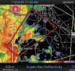
DISCUSSION...A few weak supercells have evolved out of the cluster
of storms this morning across east Texas and northwest Louisiana.
These storms are north of the greater instability, but are within a
zone of more favorable low-level shear. These storms have been
sufficiently strong for a few radar confirmed tornadoes, despite
very weak (<20 knot) vRot based on KSHV SRV data. Therefore, while
the overall environment seems to limit the overall ability for
strong low-level mesoscyclones to develop, there does seem to be
sufficient low-level shear and stretching to produce tornadoes with
any supercells that develop.
Expect additional supercell development this afternoon as
heating/destabilization increases. However, the low-level jet is
expected to weaken through the afternoon which may bring an end to
the seemingly perfect balance for a few tornado producing storms
this morning. Due to this uncertainty in the continuation of the
threat, a tornado watch is not expected. However, if this trend of
storms being efficient tornado producers continues, a watch may be
needed.
..Bentley/Marsh.. 11/03/2026