
Navigation
Install the app
How to install the app on iOS
Follow along with the video below to see how to install our site as a web app on your home screen.
Note: This feature may not be available in some browsers.
More options
-
Welcome to TalkWeather! We see you lurking around TalkWeather! Take the extra step and join us today to view attachments, see less ads and maybe even join the discussion. CLICK TO JOIN TALKWEATHER
You are using an out of date browser. It may not display this or other websites correctly.
You should upgrade or use an alternative browser.
You should upgrade or use an alternative browser.
Severe Weather Threat May 17-19, 2025
- Thread starter Brice W
- Start date
AJS
Member
I think thankfully the tornado threat won’t be as extreme today. Based on the models i’ve looked at, looks like it’ll be more geared toward damaging winds/large hail.
Kds86z
Member
Yeah dude today looks the less ominous of next 4..I think thankfully the tornado threat won’t be as extreme today. Based on the models i’ve looked at, looks like it’ll be more geared toward damaging winds/large hail.
Ledian
Member
I already ain't lookin' forward to Tuesday
Hail still no fun. My mom's at a funeral today for a friend's husband today and I don't know when she might get homeI think thankfully the tornado threat won’t be as extreme today. Based on the models i’ve looked at, looks like it’ll be more geared toward damaging winds/large hail.

AJS
Member
So sorry for her friends loss.Hail still no fun. My mom's at a funeral today for a friend's husband today and I don't know when she might get home
I really hope she stays safe out of any weather danger.SamB01
Member
Thank you.So sorry for her friends loss.
Also me, her, and granddad got weekly church service later today, but we may have to catch it online if weather get rough.
In meantime, saw this sounding on Twitter:
AJS
Member
Thank you.
Also me, her, and granddad got weekly church service later today, but we may have to catch it online if weather get rough.
In meantime, saw this sounding on Twitter:
Wonder if they’ll upgrade to a 10% for tornadoes.
Certainly looks like it.A bit out of nowhere, but isn't there a bit of rotation all the way up north here in Canada, southern QC, near Saint-Hyatinthe and La Présentation?
US_Highway15
Member
Ehh, that sounding doesn't really impress me enough to where I believe a 10% upgrade is warranted. LCL's are just under 1000 which doesn't really scream an upgradeable tornado theat. If it was around 800, I think a consoderation would be warranted.Wonder if they’ll upgrade to a 10% for tornadoes.
Not to mention, the hodograph doesn't really scream a 10% tornado upgrade.
Going back thru SPC event list, this is the first Day 4 30% "Enhanced" in May for North MS since SPC redid the whole Day 4-8 Outlook scheme.
Kds86z
Member
tennessee storm chaser
Member
- Messages
- 1,877
- Reaction score
- 4,283
- Location
- jackson tennessee
- Special Affiliations
- SKYWARN® Volunteer
Tuesday is a mid south Dixie setup.Monday and specifically Tuesday is looking like one of “those” days in the plains. Classic plains setup, exponential due points in the 70s. A bowling ball of a low. A very defined dry line. And huge cape. Seems like a thread is necessary because this is looking nasty.
Edit: Gonna also add Saturday and Sunday here too. Since it’s all the same system. (Not trying to cause confusion!) Saturday is indeed looking like the day where this is gonna come in. Haven’t checked the models for these days yet. I did see the SPC didn’t have an outlook for these two days. The potential is there however, gonna be more the lower end days it seems.
Bevo
Member
Thank you.
Also me, her, and granddad got weekly church service later today, but we may have to catch it online if weather get rough.
In meantime, saw this sounding on Twitter:
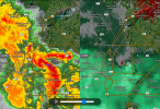
Even if the tornado threat is not as large today as the coming days, the potential for 2"+ hail over major metro areas could still be a doozy. Insurance is already very expensive for this area and an upper significant hail event would just spike it further.
Kds86z
Member
Golly i thought they were done..Tuesday is a mid south Dixie setup.
US_Highway15
Member
Which was over almost the exact same areas.
US_Highway15
Member
Saw this sounding on Twitter. This is near Kiowa KS around 7 PM CT *tomorrow*

Wonder if they’ll upgrade to a 10% for tornadoes.
Still looks more of a hail/high-wind event with low tornado threat.