Bearing in mind it's already a very high resolution image, do you any closer view of the cycloidal markings at the top of the first image?some pronounced scar left behind from the May 18th KS tor. Data are from the PLANEPT.
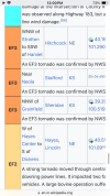
Grinnell
Plevna
Iuka
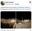
Any tor that left a scar on this kind of surface should be considered intense-violent
Or a linkable image source? (Though I know most of the super high res stuff has a fairly hefty price).