
Navigation
Install the app
How to install the app on iOS
Follow along with the video below to see how to install our site as a web app on your home screen.
Note: This feature may not be available in some browsers.
More options
-
Welcome to TalkWeather! We see you lurking around TalkWeather! Take the extra step and join us today to view attachments, see less ads and maybe even join the discussion. CLICK TO JOIN TALKWEATHER
You are using an out of date browser. It may not display this or other websites correctly.
You should upgrade or use an alternative browser.
You should upgrade or use an alternative browser.
Severe Weather Threat May 16-18, 2026
- Thread starter Brice W
- Start date
Beachwalker
Member
Iowa is really gonna take it on the chin the next few days
jiharris0220
Member
The strong wording for Day 4 is no surprise considering that all relevant global models depict a very broad negative tilt, longwave trough. This alone already surpasses the two previous most promising setups this year.
The 500mb jet streak core that rounds this trough ejects from New Mexico to Iowa in 12 hours, which is a jet translation speed of around 40-50knots. Combine this with the fact that the jet core has a velocity maximum of 80 to 90knots, you could safely call for a regional tornado outbreak just from this 500mb setup.


Let’s move in to the 850mb layer.
There’s much greater uncertainty, particularly regarding the speed of the cold front and amplitude of the surface low, in any case, not a single model depicts the LLJ weaker than 50knots.
What’s even scarier is that the LLJ as a whole where winds exceeds 35knots, covers the entire warm sector. So literally any storm regardless of where it initiates in this OWS or along the front zones especially is going to be capable of producing tornadoes (EF2+) just based off this.


At the surface, cape values exceeding 2000 are omnipresent in the OWS, my concern is the depiction of large, curved hodographs also being omnipresent in the OWS. Obviously because of the blanket 35+knot LLJ.
Did I mention that every model displays backed surface winds and critical angle values over 70 degrees throughout the OWS as well? Not a single setup this year has had the sort of kinematics where streamwiseness is a total non-issue for the entire OWS. The NAM and RRFS are about to come into range at 12z, so it will be interesting to see how they stack up to the global consensus.

Mind you, Monday also looks extremely volatile as a setup as well, particularly for the upper Midwest, but potentially for Oklahoma if the inversion layer and weak forcing can be overcome.
The 500mb jet streak core that rounds this trough ejects from New Mexico to Iowa in 12 hours, which is a jet translation speed of around 40-50knots. Combine this with the fact that the jet core has a velocity maximum of 80 to 90knots, you could safely call for a regional tornado outbreak just from this 500mb setup.
Let’s move in to the 850mb layer.
There’s much greater uncertainty, particularly regarding the speed of the cold front and amplitude of the surface low, in any case, not a single model depicts the LLJ weaker than 50knots.
What’s even scarier is that the LLJ as a whole where winds exceeds 35knots, covers the entire warm sector. So literally any storm regardless of where it initiates in this OWS or along the front zones especially is going to be capable of producing tornadoes (EF2+) just based off this.
At the surface, cape values exceeding 2000 are omnipresent in the OWS, my concern is the depiction of large, curved hodographs also being omnipresent in the OWS. Obviously because of the blanket 35+knot LLJ.
Did I mention that every model displays backed surface winds and critical angle values over 70 degrees throughout the OWS as well? Not a single setup this year has had the sort of kinematics where streamwiseness is a total non-issue for the entire OWS. The NAM and RRFS are about to come into range at 12z, so it will be interesting to see how they stack up to the global consensus.
Mind you, Monday also looks extremely volatile as a setup as well, particularly for the upper Midwest, but potentially for Oklahoma if the inversion layer and weak forcing can be overcome.
tennessee storm chaser
Member
- Messages
- 1,876
- Reaction score
- 4,283
- Location
- jackson tennessee
- Special Affiliations
- SKYWARN® Volunteer
Just the look of that trough how broad it is is concerning alone , screams super cells big timeThe fact that even after higher ceiling events like 3/16 and 4/17 this year have gone belly up, the Spc is still wording this fairly strongly at this far out, feels like room for concern
Beachwalker
Member
Troughs that long are typically a hallmark of some of the more portent outbreaks. Trey with CC has noted this in many of his recaps with historic setups that verified.Just the look of that trough how broad it is is concerning alone , screams super cells big time
Cyclonic Paracosm
Member

That is one hell of a d4 discussion like wow, anyone know when was our last heavily worded d4?
GXSC
Member
I feel like they are more common in 2026 than before, to the point where I take them somewhat less seriously, especially with regards to location. It's kind of the same with "strong tornado" risk since the SPC forecast update.View attachment 52836
That is one hell of a d4 discussion like wow, anyone know when was our last heavily worded d4?
Looking back through a couple major events, the day 4 for 4/2 is worded stronger (calling for a "widespread/potentially substantial" severe weather outbreak rather than just a severe weather outbreak) but even then they don't mention intense tornadoes.View attachment 52836
That is one hell of a d4 discussion like wow, anyone know when was our last heavily worded d4?
(That being said, not trying to say in any way that this will be as big an event as 4/2)
Ozonelayer
Member
12z NAM is in range for Monday, at the end though so take it with a grain of salt.
That being said:

(Taken in NE KS)
That being said:
(Taken in NE KS)
Last edited:
DanLarsen34
Member
just doing a quick look through old forecast discussions I have saved on my phone: May 6, 2024 didn’t use the outbreak word, but mentioned high-end severe potential. March 15 last year had their attention, but they abstained from using outbreak in the day 4 discussion. March 31, 2023 had strong wording as well, but not seeing “outbreak” mentioned.View attachment 52836
That is one hell of a d4 discussion like wow, anyone know when was our last heavily worded d4?
I am pretty confident I have seen them use it since this event, but maybe we’d have to go back to May 20, 2019 for the specific use of “outbreak” in a Day 4-8 discussion?
Regardless, it’s very rare for them to use specific words in the Day 4-8 outlooks, namely “outbreak” or “intense/violent/high-end/damaging” for tornadoes.
Last edited:
DanLarsen34
Member
Where is this sounding pulled from? You should specify which state/area this is depicting the environment of given how large of an area is at-risk.12z NAM is in range for Monday, at the end though so take it with a grain of salt.
That being said:
Ozonelayer
Member
Sorry, its in East KSWhere is this sounding pulled from? You should specify which state/area this is depicting the environment of given how large of an area is at-risk.
KUEX radar in Hastings, NE is down...because of course it is
CheeselandSkies
Member
12Z NAM is another wall-hanger of a run. I'm particularly focusing on that 60kt, slightly backed LLJ across Kansas into northeast NE.
Sure wish I could chase that area. The kicker is, I'm working this weekend because a coworker who's regularly scheduled on the weekends took PTO. I could have taken next Monday and Tuesday off to compensate, but I opted for yesterday and today because at the time of making the schedule there was no indication that this setup would take shape.
Sure wish I could chase that area. The kicker is, I'm working this weekend because a coworker who's regularly scheduled on the weekends took PTO. I could have taken next Monday and Tuesday off to compensate, but I opted for yesterday and today because at the time of making the schedule there was no indication that this setup would take shape.
jackhutwx
Member

scp gefs ensemble member 18 going crazyyy lmao. all jokes aside, this could very well be a big event of some sort.
slenker
Member
Wouldn’t be surprised if member 18 has something seriously wrong with that output, insane outlier of higher values. What could it possibly be doing to even yield values that significant across that wide of an area
CheeselandSkies
Member
Holy friggin crap
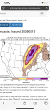
Interesting that CSU remains focused a good bit further north and east of where current model trends/SPC forecasts would suggest the greatest threat taking shape.
I rarely look at their outputs unless someone posts it because that site doesn't work for me. The images won't load in any browser on my PC. However I seem to recall their output for 3/31/23 was pretty close, but displaced a little further east (referring specifically to the northern mode). Like, it bullseyed N IL/S WI so if I had targeted based solely on that, I would have missed Keota.
member 18 is Reed's personal dynamic piping outputWouldn’t be surprised if member 18 has something seriously wrong with that output, insane outlier of higher values. What could it possibly be doing to even yield values that significant across that wide of an area
GXSC
Member
CSU-MLP I find has a slight northward bias. Stormnet is showing a severe risk that is further south than predicted, around southern IA/northern MO/northeast KS.Interesting that CSU remains focused a good bit further north and east of where current model trends/SPC forecasts would suggest the greatest threat taking shape.
I rarely look at their outputs unless someone posts it because that site doesn't work for me. The images won't load in any browser on my PC. However I seem to recall their output for 3/31/23 was pretty close, but displaced a little further east (referring specifically to the northern mode). Like, it bullseyed N IL/S WI so if I had targeted based solely on that, I would have missed Keota.


StormNet | Severe Weather Forecast + Super-Res Radar
AI-powered severe weather forecast system and super-res radar to help predict the risk of lightning, hail, tornadoes, and damaging winds for the continental United States.
 stormnet.ai
CheeselandSkies
Member
Even that still seems a good bit east of where things ought to be from a synoptic perspective based on the 12Z NAM...more like eastern Kansas and Nebraska. I wonder if these "AI" probabilities are based on some sort of ensemble of the physical models, if they run their own models, or what?