
- Thread starter
- #841
Navigation
Install the app
How to install the app on iOS
Follow along with the video below to see how to install our site as a web app on your home screen.
Note: This feature may not be available in some browsers.
More options
-
Welcome to TalkWeather! We see you lurking around TalkWeather! Take the extra step and join us today to view attachments, see less ads and maybe even join the discussion. CLICK TO JOIN TALKWEATHER
You are using an out of date browser. It may not display this or other websites correctly.
You should upgrade or use an alternative browser.
You should upgrade or use an alternative browser.
Severe WX Severe Weather Threat June 6-14
- Thread starter Kds86z
- Start date
KCweatherboy
Member
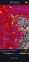
Haven't seen this reported by the NWS (and I'm not sure how to since I don't use Twitter or Facebook) but I caught a brief TDS as the line moved through Kansas City last night. It pops up SW of Birmingham, MO at 8:38 and continues the next few scans before dissapating at 8:44 S of Birmingham, MO. The other one that looks like a TDS closer to Independence was contamination as it was in front of the line at the time.
Attachments
- Thread starter
- #843
Kds86z
Member
* TORNADO WARNING FOR...
NORTHEASTERN CRAWFORD COUNTY IN NORTHWESTERN PENNSYLVANIA...
* UNTIL 515 PM EDT.
* AT 425 PM EDT, A CONFIRMED TORNADO WAS LOCATED NEAR CAMBRIDGE
SPRINGS, OR 9 MILES NORTH OF MEADVILLE, MOVING EAST AT 50 MPH.
HAZARD...DAMAGING TORNADO.
SOURCE...WEATHER SPOTTERS CONFIRMED TORNADO.
SmokeEater
Member
* TORNADO WARNING FOR...
NORTHEASTERN CRAWFORD COUNTY IN NORTHWESTERN PENNSYLVANIA...
* UNTIL 515 PM EDT.
* AT 425 PM EDT, A CONFIRMED TORNADO WAS LOCATED NEAR CAMBRIDGE
SPRINGS, OR 9 MILES NORTH OF MEADVILLE, MOVING EAST AT 50 MPH.
HAZARD...DAMAGING TORNADO.
SOURCE...WEATHER SPOTTERS CONFIRMED TORNADO.
Was on the ground in Ringold Twp.
- Thread starter
- #845
Kds86z
Member
Yep a few confirmed now.Was on the ground in Ringold Twp.
NTIL 545 PM EDT.
* AT 448 PM EDT, A CONFIRMED TORNADO WAS LOCATED OVER REYNOLDSVILLE,
MOVING EAST NORTHEAST AT 30 MPH.
HAZARD...DAMAGING TORNADO.
SOURCE...EMERGENCY MANAGEMENT CONFIRMED TORNADO.
SmokeEater
Member
Another confirmation, this may be a slightly long tracker, still down.
- Thread starter
- #847
Kds86z
Member
- Thread starter
- #848
Kds86z
Member
- Thread starter
- #850
Kds86z
Member
DISCUSSION...THE LATEST RADAR DATA FROM CCX SHOWS A FEW DISCRETE
SUPERCELLS EVOLVING ACROSS WESTERN AND CENTRAL PA AHEAD OF A COLD
FRONT AND RELATED SQUALL LINE. THE CCX VWP IS SAMPLING A 30-40 KT
LOW-LEVEL JET, WHICH IS YIELDING A CLOCKWISE-CURVED LOW-LEVEL
HODOGRAPH WITH AMPLE STREAMWISE VORTICITY FOR RM SUPERCELLS (320
M2/S2 0-1KM SRH). THIS WIND PROFILE COUPLED WITH A WARM/MOIST PBL
(MIDDLE/UPPER 60S DEWPOINTS) WILL CONTINUE TO SUPPORT A FEW DISCRETE
SUPERCELL STRUCTURES CAPABLE OF PRODUCING A COUPLE OF TORNADOES. THE
SUPERCELL TORNADO RISK WILL GENERALLY BE MAXIMIZED FOR THE NEXT FEW
HOURS (THROUGH AROUND 01Z), BEFORE THE CORE OF THE LOW-LEVEL JET
TRANSLATES NORTHWARD.
- Thread starter
- #851
Kds86z
Member
- Thread starter
- #852
Kds86z
Member
warneagle
Member
we're under a SVR watch for the third time in four days. guess we'll see if it ends up producing like the last two. we could still use more rain.
- Thread starter
- #854
Kds86z
Member
- Thread starter
- #855
Kds86z
Member
- Thread starter
- #856
Kds86z
Member
Last edited:
- Thread starter
- #857
Kds86z
Member
Ef2 found in Iowa June 11
Shakespeare 2016
Member
Yeah, that looks about right for that area.
- Thread starter
- #859
Kds86z
Member
KakashiHatake2000
Member
wow is all i have to say