- Thread starter
- #301
Kds86z
Member
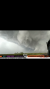
Lubbock storm may be ramping up.
We got chasers on it I imagine..
Follow along with the video below to see how to install our site as a web app on your home screen.
Note: This feature may not be available in some browsers.
Lubbock storm may be ramping up.


Meanwhile in my part of Colorado just now.
View attachment 43806View attachment 43807View attachment 43805

Thanks. Can't remember the last time we've had hail like this where I live. It's been a long time since I've actually seen real honest to god hail. Most of the stuff we get is mostly just the little popcorn stuff.Nice pics @TornadoFan