EastTexasWx
Member
Yea that spun up really fast I think were gonna see something soonmight be 3 areas with 2 very close to each other.
View attachment 53994
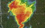
somthing is really trying.
View attachment 53995
Follow along with the video below to see how to install our site as a web app on your home screen.
Note: This feature may not be available in some browsers.
Yea that spun up really fast I think were gonna see something soonmight be 3 areas with 2 very close to each other.
View attachment 53994
somthing is really trying.
View attachment 53995

Maybe the smaller ones, but I think the Fargo one is just dealing with some mergers.Low level lapse rates might end up causing these storms to struggle.


I doubt it, think it'll get absorbed into the hook.I'm still not convinced that Southern cell isn't going to repeatedly choke off the Fargo storm's inflow. Low level SRH is very impressive though, so anything can happen I suppose.
View attachment 53997View attachment 53996

Overconvection, it has been ramping up over the last hour though.What are we missing? Shear (again)? Little too warm in the lower levels?
I doubt it, think it'll get absorbed into the hook.
Not at all.Overconvection, it has been ramping up over the last hour though.