Admittedly my meterological knowledge isn't top notch whatsoever, but I'd like to dive into some of the mesoscale details that followed Enderlin. It really is intriguing.
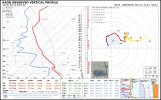
Let's start off with a proximity sounding taken near the vicinity. Strong 700 mb warm nose! You would think this doesn't convect. Well, actually 12-14C is breakable in June, as Trey said in the live, 1 or 2 more and we wouldn't be able to convect prefrontals. Strong low level shear overcame what was beginning to settle in as a low level inversion, and the cell sustained itself despite strong dry air with extreme CAPE hanging around!
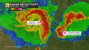
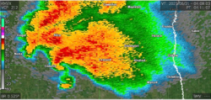
Courtesy of The Weather Network, this reflectivity picture shows it all. The mesoscale details are very important, and something i think led to Enderlin intensifying into EF5. The derecho is very visible, and we've seen cases of enhanced tornadogenesis occurring within lines before. The derecho's outflow surges like a haboob, hits the back of the cell and suddenly it produces a tornado. That wasn't all though. Taking a look at the Enderlin supercell in high res, a very classic supercell is visible with a rather LP hook. To its south is a NUDGER. this little rfd enhancement hits the south side of the cell, and i presume this combined with the outflow + occluding meso + nudger makes this tornado BOMB out in intensity and become a extremely violent EF5.
We were very close to dodging this event but your 700 mb temps JUST BARELY made it. And the mesoscale manages to do the rest and create a historic tornado. Hopefully, this explanation is understandable! I've just came to this theory within analysing a lot of the radar and i think it makes sense somewhat. Corrections would be appreciated if i have got something incorrect!

")