
Navigation
Install the app
How to install the app on iOS
Follow along with the video below to see how to install our site as a web app on your home screen.
Note: This feature may not be available in some browsers.
More options
-
Welcome to TalkWeather! We see you lurking around TalkWeather! Take the extra step and join us today to view attachments, see less ads and maybe even join the discussion. CLICK TO JOIN TALKWEATHER
You are using an out of date browser. It may not display this or other websites correctly.
You should upgrade or use an alternative browser.
You should upgrade or use an alternative browser.
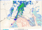
Severe Weather Threat - January 8th-9th, 2024
- Thread starter Taylor Campbell
- Start date
-
- Tags
- severe weather
Before I leave. You beat me to it lol. I was about to post that. That's nasty.
TOR for that supercell making landfall.
TOR for storm over Mobile Bay.

BULLETIN - EAS ACTIVATION REQUESTED
Tornado Warning
National Weather Service Mobile AL
425 AM CST Tue Jan 9 2024
The National Weather Service in Mobile has issued a
* Tornado Warning for...
Central Baldwin County in southwestern Alabama...
* Until 500 AM CST.
* At 424 AM CST, severe thunderstorms capable of producing both
tornadoes and extensive straight line wind damage were located over
Spanish Fort, moving east at 45 mph.
HAZARD...Tornado.
SOURCE...Radar indicated rotation.
IMPACT...Flying debris will be dangerous to those caught without
shelter. Mobile homes will be damaged or destroyed.
Damage to roofs, windows, and vehicles will occur. Tree
damage is likely.
* This tornadic thunderstorm will remain over mainly rural areas of
central Baldwin County.
PRECAUTIONARY/PREPAREDNESS ACTIONS...
TAKE COVER NOW! Move to a basement or an interior room on the lowest
floor of a sturdy building. Avoid windows. If you are outdoors, in a
mobile home, or in a vehicle, move to the closest substantial shelter
and protect yourself from flying debris.
Keeping my talk weather on to see the updates lol putting it on my phone holder lol
KevinH
Member
Wait… when did the SPC/NOAA define the criteria for an outbreak?Already nearing the criteria for tornado outbreak in half a hour. F.
Zabwxaj
Member
Reed might have just missed the land falling waterspout. The winds were definitely ripping and he kept screaming “that’s it!” But it is Reed so it could have just been RFD, haha.
Sent from my iPhone using Tapatalk
Sent from my iPhone using Tapatalk


Equus
Member
Extremely dangerous velocity sig, this could be very intense


Equus
Member
I gotta sleep soon but there's another rapidly rotating supercell offshore behind the panhandle one that bears close watching if it holds together to landfall
Remarkable radar presentation.I gotta sleep soon but there's another rapidly rotating supercell offshore behind the panhandle one that bears close watching if it holds together to landfall
