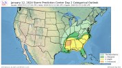
...Southeast Friday morning into the evening...
As the primary surface low occludes over the Mid MS valley, and
associated cold front is forecast to move quickly eastward across
the Southeast states. Low 60s dewpoints are expected to advect
northward just ahead of this front across southern portion of MS,
AL, GA, and the FL Panhandle, with the fast eastward-progression of
the cold front acting as a limiting factor for stronger moisture
return. This limited low-level moisture, combined with warmer
mid-level temperatures, will likely limit overall buoyancy,
tempering updraft strength and storm severity. Some stronger storms
are still possible, particularly if low-level moisture is better
than forecast, with strong kinematics supporting the potential for
some damaging convective gusts. Cell mergers could also augment
storm strength enough to produce some strong gusts. A tornado or two
is also possible if a storm can maintain discrete characteristics
and longer updraft duration. However, given the anticipated
thermodynamic profiles, the tornado threat appears lower than
previously anticipated.


