
Navigation
Install the app
How to install the app on iOS
Follow along with the video below to see how to install our site as a web app on your home screen.
Note: This feature may not be available in some browsers.
More options
-
Welcome to TalkWeather! We see you lurking around TalkWeather! Take the extra step and join us today to view attachments, see less ads and maybe even join the discussion. CLICK TO JOIN TALKWEATHER
You are using an out of date browser. It may not display this or other websites correctly.
You should upgrade or use an alternative browser.
You should upgrade or use an alternative browser.
Severe Weather Threat - Christmas Week 2022 (AKA The Great Big Batch of Every Gosh-Darn Thing)
- Thread starter Lake Martin EF4
- Start date
- Admin
- #23
- Messages
- 3,618
- Reaction score
- 3,431
- Location
- Fayetteville, AR
- Special Affiliations
- SKYWARN® Volunteer
Meanwhile in NW Arkansas... that wind chill is looking real fun later this week... -25.. really?
Sawmaster
Member
Low temp of 16 and wind chill of 6 in Upstate SC expected. We haven't had a really cold day in December like this since 2010 
KevinH
Member
This thread seems more of a winter weather threat instead of severe. Either way, not going to be a good weekend for part of the population
And here's the Thursday night through Sunday Temperature output off the 18z GFS, 12z Euro, and 12z Canadian for Monroe County, MS, Tupelo, MS, and Columbus, MS. Just made this using the meteograms off Weatherbell.
brianc33710
Member
The Euro has 7F/-14C in Birmingham Sat am & I think its right. This would match Jans '03 & '14 for coldest temp of 21st Century.
Edit GFS shows 9F/-13C.I

Edit GFS shows 9F/-13C.I
Last edited:
TH2002
Member
- Messages
- 4,974
- Reaction score
- 11,116
- Location
- California, United States
- Special Affiliations
- SKYWARN® Volunteer
Even though the severe threat does look negligible right now (Florida through the eastern Carolinas on the southern end of this system as the cold front pushes through) after Winterset and Gaylord I always have to double take at even the most marginal setups...This thread seems more of a winter weather threat instead of severe. Either way, not going to be a good weekend for part of the population
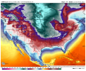
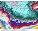
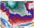
00z GFS, Canadian, and ICON model temperature/apparent temperature (aka Wind Chill values) valid at 6am Friday. INSANE!
.png")
.png")
.png")
.png")
.png")
brianc33710
Member
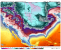
While it's definitely an outlier the CAC keeps overnight lows under 15F/-9.5C for nights on end across Central AL & has hard freezes well down into the FL Peninsula. But its strange isotherm distribution in TX after Christmas kind of negates CMCs reliability for me. Here's what I mean with the CAC & TX.00z GFS, Canadian, and ICON model temperature/apparent temperature (aka Wind Chill values) valid at 6am Friday. INSANE!
View attachment 16175View attachment 16174View attachment 16173View attachment 16172View attachment 16171

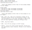
CIPS showing a threat area for Day 3 (12/22), mostly for wind, with highlighted areas having shown up for the 2 days previous, indicating some level of consistency. Can't remember if it's any good at forecasting cold-season events, though. (Reposted here because I posted it in the 2022 thread on accident, my bad!)

TH2002
Member
- Messages
- 4,974
- Reaction score
- 11,116
- Location
- California, United States
- Special Affiliations
- SKYWARN® Volunteer
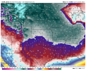
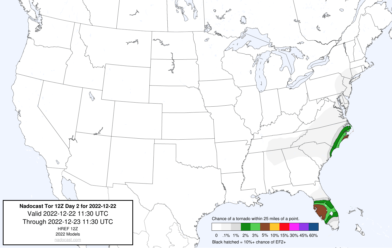
NAM and GFS are fairly consistent in showing some isolated tornado probabilities near or just off the North Carolina coast on 12/22. Curious to see if Nadocast picks up on anything.
- Moderator
- #34
Great forecast discussion from Davis at NWS Birmingham.
.LONG TERM...
(Wednesday night through Monday)
Issued at 347 AM CST TUE DEC 20 2022
...BITTER COLD AND BLUSTERY CONDITIONS EXPECTED THURSDAY NIGHT
INTO SUNDAY...
A subtropical impulse will lift northeast across the area
Wednesday night and Thursday morning. Lift with this feature as
well as low-level isentropic lift as a warm front lifts northward
and a weak surface low approaches the Gulf Coast will result in a
chance of showers across the area. A mid-level dry slot may result
in a lull in shower activity Thursday afternoon. Some guidance
indicates some elevated MUCAPE developing, but with the lack of
agreement in this occurring and uncertainty if any elevated
convection will develop will not mention thunder at this time.
There is some uncertainty in high temperatures depending on
cloudcover and precipitation as well as lingering wedge effects in
the northeast counties, but it will by far by the warmest day of
the extended period.
The well-advertised deep trough will amplify along the Mississippi
Valley Thursday and Thursday night, with bomb cyclogenesis
occurring from the Ohio Valley up into the Great Lakes. Meanwhile
a near 1060mb high over Montana results in an impressive Arctic
outbreak across the central and eastern CONUS. Guidance continues
to trend toward the ECMWF with both a faster exit to precipitation
and a quicker arrival of the colder temperatures. However,
most forecast soundings continue to indicate moisture drying up as
the cold air arrives. A brief changeover to light snow/flurries
remains possible on the backside of precipitation across the far
northern counties, but not especially likely. Accumulations are
still not expected at this time. The GFS attempts to show
soundings briefly supporting freezing rain, but will not mention
in the forecast at this time given the lack of other supporting
guidance and pending finer details from the high res models. Most
guidance drys out the low-levels quickly Friday morning, but if
enough moisture does get trapped under the low-level inversion for
low stratus/stratocumulus then some flurries would be possible.
Any remaining moisture on roadways would probably re-freeze by
Friday morning, though strong winds may help with drying somewhat.
Guidance continues look more and more impressive with the Arctic
air mass moving in behind the front, with 925mb and 850mb
temperatures as cold as -22C across the far north on Friday. Lows
Thursday night and Friday night will be driven by pure cold air
advection due to strong winds, while radiational cooling begins to
come into play Saturday and Sunday nights as winds become lighter.
Latest trends now have almost the entire area reaching hard freeze
warning criteria of 20 degrees or lower Friday morning, with
single digits common across the far northern counties. Lows
Saturday night range from the single digits to lower teens
areawide, and lows in the teens remain common Sunday night and
Monday night. Highs Friday will be very cold with upper teens to
low 20s across the north and mid 20s across the south.
Temperatures remain below freezing for highs on Christmas Eve, and
areas across the north may remain below freezing Christmas Day as
well. This will be the coldest air mass since 2018, but the most
prolonged cold event since at least 2014. This is the coldest
December air mass since 1989. Unusually, these temperatures will
also be overlapped with strong gusty winds Thursday night into
Saturday, with a prolonged period of subzero wind chills. Record
low temperatures and record cold high temperatures are listed in
the climate section but will be difficult to break as they are
from 1989 and 1983.
The prolonged period of temperatures well below freezing and low
wind chills make this a very significant and life-threatening
cold event for our area. This is due to the potential impacts on
infrastructure such as burst pipes, and hypothermia risk for
people (especially vulnerable populations) and animals with
prolonged exposure/lack of access to adequate warmth. Remember the
three P`s: protect people, pets, pipes. It also important for
alternative heat sources such as space heaters to be used safely
to prevent carbon monoxide poisoning and fires.
Given these impacts, a hard freeze watch has been issued earlier
than normal starting Thursday night and run through Christmas Day
given the continuous hours below freezing. An additional hard
freeze watch will likely need to be issued later on for Christmas
night. A wind chill watch has also been issued for areas along and
northwest of I-85 where subzero wind chills are forecast Thursday
night through Saturday. Northern portions of this watch may be
upgraded to a wind chill warning for wind chills of -10 to -15,
while other areas will probably be upgraded to a wind chill
advisory for wind chills of 0 to -10. Per data from the IEM site,
prior to this event wind chill watches and warnings have not been
issued by the BMX office since at least the start of the VTEC era
~2006. A wind advisory will probably eventually be needed for
Thursday night into Friday. Any localized power outages caused by
gradient winds in this time frame would exacerbate the situation.
Temperatures finally "warm" up into the 40s in most areas by
Monday. A clipper system moves through Monday/Monday night but
moisture appears limited at this time.
32/Davis
TH2002
Member
- Messages
- 4,974
- Reaction score
- 11,116
- Location
- California, United States
- Special Affiliations
- SKYWARN® Volunteer
D2 Nadocast. SPC picked up on and highlighted a MRGL risk area in the Carolinas (albeit without highlighting a tornado threat) although the models aren't picking up on the FL threat, at least the GFS isn't.
Tupelo, MS is forecasted to see a high of 21 on Friday with a low of 10. You have to go all the way back to December 25th, 1985 to find a high in the mid-20s and further back to December 24th, 1983 to find a high of 16. To find a low of 10 in December for Tupelo, you have to go back to December 16th, 1951! For Aberdeen, MS: Friday's high is 23 with a low of 10. To find a high temperature of around 23 in December for Aberdeen, you have to go back to December 17th, 1932! To find a low temperature of 10, you have to go back to December 20th, 1981! This is only the 3rd time that North MS has been put under a Wind Chill Advisory in December. The last two occurrences were December 2017 and again in 2010. The northern counties of North MS are now under a Wind Chill Warning. This is the first time ever on record that NWS Memphis has issued a Wind Chill Warning in the month of December.
The 18z HRRR has northern Monroe County getting between 1 and -1 by 6am Friday with a wind chill temperature of around -17 with gusts to 26mph. If this occurs, it will be my coldest December temperature since 1989!
The 18z HRRR has northern Monroe County getting between 1 and -1 by 6am Friday with a wind chill temperature of around -17 with gusts to 26mph. If this occurs, it will be my coldest December temperature since 1989!
Here's all the coldest lows and cold high temps in December for Tupelo since 1932.

TH2002
Member
- Messages
- 4,974
- Reaction score
- 11,116
- Location
- California, United States
- Special Affiliations
- SKYWARN® Volunteer
Looks like the greatest tornado potential should stay offshore, so perhaps a good day for a waterspout chase? Regardless, 2% tornado probs added in the latest SPC outlook, and most model guidance is suggesting a tornado threat in the Carteret County, NC area.
Austin Dawg
Member
I lived in Amory during this cold stretch and was working in Tupelo in 85. Rough times for North MS. Mom said she was gonna try to stay warm, y'all watch it. It's not quite supposed to be close to that cold here in Austin, but it will be close.Tupelo, MS is forecasted to see a high of 21 on Friday with a low of 10. You have to go all the way back to December 25th, 1985 to find a high in the mid-20s and further back to December 24th, 1983 to find a high of 16. To find a low of 10 in December for Tupelo, you have to go back to December 16th, 1951! For Aberdeen, MS: Friday's high is 23 with a low of 10. To find a high temperature of around 23 in December for Aberdeen, you have to go back to December 17th, 1932! To find a low temperature of 10, you have to go back to December 20th, 1981! This is only the 3rd time that North MS has been put under a Wind Chill Advisory in December. The last two occurrences were December 2017 and again in 2010. The northern counties of North MS are now under a Wind Chill Warning. This is the first time ever on record that NWS Memphis has issued a Wind Chill Warning in the month of December.
The 18z HRRR has northern Monroe County getting between 1 and -1 by 6am Friday with a wind chill temperature of around -17 with gusts to 26mph. If this occurs, it will be my coldest December temperature since 1989!
