• Welcome to TalkWeather!
    We see you lurking around TalkWeather! Take the extra step and join us today to view attachments, see less ads and maybe even join the discussion.
    CLICK TO JOIN TALKWEATHER

Severe WX Severe Weather Threat April 27-30, 2021

Adam Lucio and Chelsea Burnett reporting a large rain-wrapped wedge tornado with that cell.
 
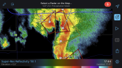
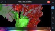
SPC just released a new MD mentioning the possibility of hail up to 2.25 inches in diameter from that cell.
For some reason we get more hail and high wind storms from south central TX north west to the end of the hill country just south of I-20.
I'll have to find it but I read somewhere that TX, OK, and the plains are trending towards a rough May. The end of April through Memorial Day is traditionally when we have our strongest storms and flash flood events. It shocked me after I moved here just how prone we are to flash flooding events here in Central Texas until I realized we had a very shallow amount of topsoil right on top of limestone that will quickly become saturated leaving the rest of the water with no place to go but towards the drainage paths it chooses.
 
TOG near Sweetwater, TX
View attachment 9343

Very odd structure to that, the warning polygon is nowhere near the classic reflectivity inflow region/meso. Couple of the storms earlier near Vernon/Frederick looked pretty good (as did the ones in CO); today overachieved my expectations a bit.
 
These twin warned storms in CO earlier toady were pretty interesting to watch on the radar loop.
 

Attachments

  • B8D945DE-2C88-435B-A8C2-49007D32A34B.png
    B8D945DE-2C88-435B-A8C2-49007D32A34B.png
    568.8 KB · Views: 0
  • C8AFB812-CFB9-45C1-A8DE-A903AE4B1F37.png
    C8AFB812-CFB9-45C1-A8DE-A903AE4B1F37.png
    483.4 KB · Views: 0
Tornado in progress near Pauls Valley OK right now.
 
Update: TDS has disappeared with the most recent scan and couplet is significantly weaker. Storm should also miss OKC to the east but other communities including Bethel Acres, Pink, Tecumseh and Shawnee could end up in the path if the storm reintensifies.
 
Back
Top