
Navigation
Install the app
How to install the app on iOS
Follow along with the video below to see how to install our site as a web app on your home screen.
Note: This feature may not be available in some browsers.
More options
-
Welcome to TalkWeather! We see you lurking around TalkWeather! Take the extra step and join us today to view attachments, see less ads and maybe even join the discussion. CLICK TO JOIN TALKWEATHER
You are using an out of date browser. It may not display this or other websites correctly.
You should upgrade or use an alternative browser.
You should upgrade or use an alternative browser.
Severe WX Severe Weather Threat April 23-24, 2021
- Thread starter MattPetrulli
- Start date

us89
Member
I'm thinking the afternoon/evening threat for northeast AL/northern GA might be a little higher than the forecast thinking earlier today. The 12z NAM3k showed a very strong wedge extending all the way into central AL that didn't budge at all, while the HRRR has been more aggressive with advancing the warm front northward. The HRRR seems to have a better handle on temperature trends , as heating has been pretty good so far even under the clouds (as I type this it's almost 10 degrees warmer at KATL than the NAM3k had) and a substantial region of clearing is rapidly advancing into GA which will almost certainly destabilize the airmass.
Both models have consistently indicated development of storms over AL and west GA late this afternoon, likely reaching the Atlanta metro by the 8 PM EDT timeframe. Difference is that we'll probably have more instability to work with than we maybe thought this morning.
Both models have consistently indicated development of storms over AL and west GA late this afternoon, likely reaching the Atlanta metro by the 8 PM EDT timeframe. Difference is that we'll probably have more instability to work with than we maybe thought this morning.
bwalk
Member
4/24 3pm CST Tornado Warning for Central/South Alabama
...A TORNADO WARNING REMAINS IN EFFECT UNTIL 330 PM CDT FOR EAST
CENTRAL CONECUH COUNTY...
At 300 PM CDT, a severe thunderstorm capable of producing a tornado
was located over I65 And US 84, or 4 miles west of Evergreen, moving
east at 50 mph.
HAZARD...Tornado and tennis ball size hail.
SOURCE...Radar indicated rotation.
bwalk
Member
Rotation appears to be weak and diffused on the Alabama Conecuh Co tornado warning per my GRL3. More of a hail threat atm.

brianc33710
Member
OK 3 pm SPC adds E-Cen AL back to slight but watch still well sough of us. BMX has Bham marginal.
bwalk
Member
Tornado warned cell 3:30 pm CDT Clarke Co (SW Alabama). Weak rotation but hail is a factor. Vertically Integrated Liquid is off the chart at 80+ KG/M2 (indicative of tall updraft reaching into the colder air & thus producing hail).

Weatherphreak
Member
Got a couple of SVR storms sneaking up on North Alabama. Was beautiful for a large portion of the day. Glad to see Dega dodge the weather so far.
Equus
Member
Pea sized hail here with severe warned storm earlier.
brianc33710
Member
Yeah BMX just issued warning for SW Blount & NE Jefferson Cos. That includes me.
ALC009-073-242200-
/O.NEW.KBMX.SV.W.0067.210424T2135Z-210424T2200Z/
BULLETIN - IMMEDIATE BROADCAST REQUESTED
Severe Thunderstorm Warning
National Weather Service Birmingham AL
435 PM CDT Sat Apr 24 2021
The National Weather Service in Birmingham has issued a
* Severe Thunderstorm Warning for...
Southwestern Blount County in central Alabama...
North central Jefferson County in central Alabama...
* Until 500 PM CDT.
* At 435 PM CDT, a severe thunderstorm was located near Arkadelphia,
or 10 miles northeast of Sumiton, moving east at 50 mph.
HAZARD...60 mph wind gusts and quarter size hail.
SOURCE...Radar indicated.
IMPACT...Hail damage to vehicles is expected. Expect wind damage
to roofs, siding, and trees.
* Locations impacted include...
Dallas, Warrior, Kimberly, Locust Fork, Trafford, Hayden, Nectar,
County Line, Blount Springs, Bangor, Arkadelphia, Smoke Rise,
Remlap, Rickwood Caverns and Partridge Crossroads.
PRECAUTIONARY/PREPAREDNESS ACTIONS...
For your protection move to an interior room on the lowest floor of a
building.
&&
LAT...LON 3380 8657 3377 8658 3376 8696 3379 8697
3380 8695 3387 8696 3387 8692 3391 8692
3392 8689 3394 8688 3393 8686 3395 8684
3394 8682 3396 8682 3395 8679 3397 8677
3399 8676 3403 8670 3405 8671 3407 8669
TIME...MOT...LOC 2135Z 264DEG 42KT 3384 8689
HAIL...1.00IN
WIND...60MPH
$$
75 Linhares
Severe Thunderstorm Warning
Severe Thunderstorm WarningALC009-073-242200-
/O.NEW.KBMX.SV.W.0067.210424T2135Z-210424T2200Z/
BULLETIN - IMMEDIATE BROADCAST REQUESTED
Severe Thunderstorm Warning
National Weather Service Birmingham AL
435 PM CDT Sat Apr 24 2021
The National Weather Service in Birmingham has issued a
* Severe Thunderstorm Warning for...
Southwestern Blount County in central Alabama...
North central Jefferson County in central Alabama...
* Until 500 PM CDT.
* At 435 PM CDT, a severe thunderstorm was located near Arkadelphia,
or 10 miles northeast of Sumiton, moving east at 50 mph.
HAZARD...60 mph wind gusts and quarter size hail.
SOURCE...Radar indicated.
IMPACT...Hail damage to vehicles is expected. Expect wind damage
to roofs, siding, and trees.
* Locations impacted include...
Dallas, Warrior, Kimberly, Locust Fork, Trafford, Hayden, Nectar,
County Line, Blount Springs, Bangor, Arkadelphia, Smoke Rise,
Remlap, Rickwood Caverns and Partridge Crossroads.
PRECAUTIONARY/PREPAREDNESS ACTIONS...
For your protection move to an interior room on the lowest floor of a
building.
&&
LAT...LON 3380 8657 3377 8658 3376 8696 3379 8697
3380 8695 3387 8696 3387 8692 3391 8692
3392 8689 3394 8688 3393 8686 3395 8684
3394 8682 3396 8682 3395 8679 3397 8677
3399 8676 3403 8670 3405 8671 3407 8669
TIME...MOT...LOC 2135Z 264DEG 42KT 3384 8689
HAIL...1.00IN
WIND...60MPH
$$
75 Linhares
Last edited:

Evan
Member
Storm near Newville is, uh, interesting.
brianc33710
Member
New Watch
NWS STORM PREDICTION CENTER NORMAN OK
455 PM CDT SAT APR 24 2021
SEVERE THUNDERSTORM WATCH 110 IS IN EFFECT UNTIL 900 PM CDT
FOR THE FOLLOWING LOCATIONS
ALC007-009-015-017-019-021-027-029-037-049-055-071-073-089-095-
111-115-117-121-123-125-250200-
/O.NEW.KWNS.SV.A.0110.210424T2155Z-210425T0200Z/
AL
. ALABAMA COUNTIES INCLUDED ARE
BIBB BLOUNT CALHOUN
CHAMBERS CHEROKEE CHILTON
CLAY CLEBURNE COOSA
DEKALB ETOWAH JACKSON
JEFFERSON MADISON MARSHALL
RANDOLPH SHELBY ST. CLAIR
TALLADEGA TALLAPOOSA TUSCALOOSA
$$
Severe Thunderstorm Watch
SEVERE THUNDERSTORM WATCH OUTLINE UPDATE FOR WS 110NWS STORM PREDICTION CENTER NORMAN OK
455 PM CDT SAT APR 24 2021
SEVERE THUNDERSTORM WATCH 110 IS IN EFFECT UNTIL 900 PM CDT
FOR THE FOLLOWING LOCATIONS
ALC007-009-015-017-019-021-027-029-037-049-055-071-073-089-095-
111-115-117-121-123-125-250200-
/O.NEW.KWNS.SV.A.0110.210424T2155Z-210425T0200Z/
AL
. ALABAMA COUNTIES INCLUDED ARE
BIBB BLOUNT CALHOUN
CHAMBERS CHEROKEE CHILTON
CLAY CLEBURNE COOSA
DEKALB ETOWAH JACKSON
JEFFERSON MADISON MARSHALL
RANDOLPH SHELBY ST. CLAIR
TALLADEGA TALLAPOOSA TUSCALOOSA
$$
CSimonds
Member
A surprise in Guntersville, AL we had been taken out of the slight risk so we weren’t expecting this. We were outside doing yard work when they put us back in the slight risk and added the severe thunderstorm watch. Hopefully the truck doesn’t have too much damage.
Attachments
Kolle
Member
Watch already canceled for Madison and Marshall Counties. That was fast.New Watch
Severe Thunderstorm Watch
SEVERE THUNDERSTORM WATCH OUTLINE UPDATE FOR WS 110
NWS STORM PREDICTION CENTER NORMAN OK
455 PM CDT SAT APR 24 2021
SEVERE THUNDERSTORM WATCH 110 IS IN EFFECT UNTIL 900 PM CDT
FOR THE FOLLOWING LOCATIONS
ALC007-009-015-017-019-021-027-029-037-049-055-071-073-089-095-
111-115-117-121-123-125-250200-
/O.NEW.KWNS.SV.A.0110.210424T2155Z-210425T0200Z/
AL
. ALABAMA COUNTIES INCLUDED ARE
BIBB BLOUNT CALHOUN
CHAMBERS CHEROKEE CHILTON
CLAY CLEBURNE COOSA
DEKALB ETOWAH JACKSON
JEFFERSON MADISON MARSHALL
RANDOLPH SHELBY ST. CLAIR
TALLADEGA TALLAPOOSA TUSCALOOSA
$$
Sent from my SM-A600P using Tapatalk

Posted my chase account on Stormtrack from what was an incredible show near Vernon and Lockett TX yesterday featuring multiple photogenic tornadoes.

 stormtrack.org
2021-04-23 REPORTS: AR/LA/MS/OK/TX
Initsl target Vernon TX to play the triple point. Most folks headed toward the cell that fired near Childress, but we went towards Crowell and wIsited n southern Foard Co.. The Childress cell got svr then tor warned but we held fast for an hour and our cell finally became svr warned.and we ended...
CheeselandSkies
Member
Argus
Member
Brittany and I have lived in the Athens area for fifteen years. We have never seen it get so dark so early before sunset in the middle of Athens. That's what she described to me while she was out this afternoon.
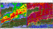
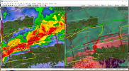
This storm had a major couplet and TDS WSW of Tifton, as well.Possible TDS with this one, although not included in the warning yet: