• Welcome to TalkWeather!
    We see you lurking around TalkWeather! Take the extra step and join us today to view attachments, see less ads and maybe even join the discussion.
    CLICK TO JOIN TALKWEATHER

Severe WX Severe Weather Threat April 23-24, 2021

MattW

Member
Messages
307
Reaction score
206
Location
Decatur, GA
HAM Callsign
KG4GUF
Special Affiliations
  1. SKYWARN® Volunteer
Wow...I can't believe it's been that long. I remember watching that radar signature live, as well as reading Talkweather throughout the night. In the fall, that episode of Storm Chasers on Discovery Channel stood out for me.
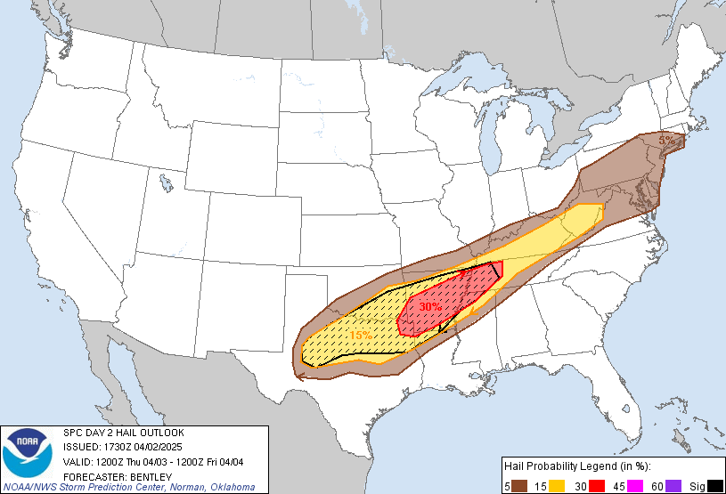
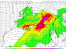
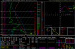
I don't see how the atmosphere will be able to recover in 48 hours. I'm anticipating a wedge situation could develop over Georgia.

Temperatures will be cool, but I'm not seeing any evidence of a wedge on the NAM or GFS. I am however seeing this on the NAM. Yes, that little purple dot has a SigTor of 8.4 for Georgia...downright NASTY for this area. I won't post the sounding, children might be reading this forum... I'll be very interested to see what the high-res NAM shows for convection.
 

Attachments

  • 2021042118zNAMSE_con_stp_072.png
    2021042118zNAMSE_con_stp_072.png
    149.7 KB · Views: 0

MattW

Member
Messages
307
Reaction score
206
Location
Decatur, GA
HAM Callsign
KG4GUF
Special Affiliations
  1. SKYWARN® Volunteer
12z Hi-Res NAM is in. This is about 30 miles SW of Macon, GA. Is the NAM smoking something again? Or is it still too far out? It's also not showing convection for that area, keeping it to Atlanta and north. Am I missing something?
 

Attachments

  • 2021042212_NAMNST_057_32.64,-84.06_severe_ml.png
    2021042212_NAMNST_057_32.64,-84.06_severe_ml.png
    192.2 KB · Views: 0

andyhb

Member
Messages
1,035
Reaction score
2,697
Location
Norman, OK
Pending early convection/possible MCS from Friday impacting the northward extent of the warm sector (which is a very real possibility), Saturday is a pretty typical sig tor setup for the eastern part of the SE with a relatively low amplitude wave/westerly flow aloft and strong WSW/SW flow at 850 mb. Any backing of the surface winds towards southerly would rapidly increase low-level SRH to very high levels in cases such as this.
 

MattW

Member
Messages
307
Reaction score
206
Location
Decatur, GA
HAM Callsign
KG4GUF
Special Affiliations
  1. SKYWARN® Volunteer
So far the HRRR is unimpressed for Georgia, but the extended range at 18z is not what the model is best at. NAM 3km still says lots of potential.
 

us89

Member
Messages
2
Reaction score
1
Location
Atlanta, GA
This is one model run (and the 18z was not nearly as bad as the 12z below), but the NAM3k is portraying what could be a very scary situation for the Atlanta metro. Especially if instability is able to recover from any morning rain. I have to say this is not what I expected to see when I clicked over downtown ATL.

It would be an interesting change of pace for Atlanta to get a severe storm in the afternoon for once. Last several rounds of severe weather here have been either in the middle of the night or early morning.

 
Last edited:

MattW

Member
Messages
307
Reaction score
206
Location
Decatur, GA
HAM Callsign
KG4GUF
Special Affiliations
  1. SKYWARN® Volunteer
It looks like the 0z HRRR and NAM Hi Res are split, but converging. Both have now latched on to cellular storms behind the morning rain appearing by 4m EDT, along with the required atmospheric recovery. The morning rain leaves Atlanta in the 50s, but both models show Atlanta reaching nearly 70 by the time the afternoon storms start to form. The split now is location. NAM wants to put Atlanta Metro under the gun, HRRR seems to be centered more on Macon, GA. NAM is also still showing large-scale ridiculously high SigTor values up to 13.2. But I'm wondering if that has to do more with model resolution? The HRRR does put STP values up over 7, but only very localized around the specific storms it wants to develop.
 

Austin Dawg

Member
Sustaining Member
Messages
852
Reaction score
1,299
Location
Leander, Texas
The atmosphere is gonna have to make a dramatic recovery. Right now 62/26 in Atlanta.
It will begin tomorrow over here in Texas and Oklahoma. It will move right over to you. Last night it was 40 degrees with dewpoints in the 30's

Dewpoint and Temp are both back in the 60s with a southern wind pulling in the moisture. This is from the airport.
pasrt 24 hra.jpg
 

Marshal79344

Member
Messages
361
Reaction score
1,064
Location
Chicago, IL
For me, some of the CAM's have been hinting at pre-frontal supercell activity on the morning of 4/24, but the thermodynamics are too marginal to support several, maybe a few supercells could form due to kinematic intensity. Any supercell that does form will have significant tornado potential, but the potential for this scenario to occur is over such a large area that it's hard to tell. Most of the talk is about the dryline and shear potential in TX/OK/LA, but MS, AL, and FL should be watched too.
 

Clancy

Member
Messages
2,298
Reaction score
3,972
Location
Macland, Georgia
A bit worried people in the ATL metro might not be paying attention to tomorrow's afternoon storms. Not too many people (especially in tv weather) are saying much about it. It's certainly a somewhat conditional threat but some of the forecasted values are higher for the area than in either of the March events.
 

MattW

Member
Messages
307
Reaction score
206
Location
Decatur, GA
HAM Callsign
KG4GUF
Special Affiliations
  1. SKYWARN® Volunteer
Well the 12z models are still split, with the addition of the HRRR wanting to form a wedge across N GA while the NAM shows no such thing. Does the NAM have a bias against the wedge in this area? I can't remember.
 

MattW

Member
Messages
307
Reaction score
206
Location
Decatur, GA
HAM Callsign
KG4GUF
Special Affiliations
  1. SKYWARN® Volunteer
Looks like SPC is leaning toward the HRRR.
 

Bama Ravens

Member
Messages
1,207
Reaction score
649
Location
Morris, AL (Northern Jefferson County)
New enhanced risk for tomorrow, and SPC has upped the tornado and severe hail probabilities for tomorrow.

day2otlk_1730.gif


Tornado probabilities

day2probotlk_1730_torn.gif


Hail probabilities

day2probotlk_1730_hail.gif
 

kcyalater

Member
Messages
340
Reaction score
341
Location
Birmingham, AL
How many times have we seen models progging an overly primed atmosphere due to lack of an MCS or mitigating blob of rain on the coast? Now we have modeling showing the blob of rain but atmosphere recovery.
 
Back
Top