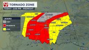
• Welcome to TalkWeather!
    We see you lurking around TalkWeather! Take the extra step and join us today to view attachments, see less ads and maybe even join the discussion.
    CLICK TO JOIN TALKWEATHER

Severe Weather Threat April 1-4

Welp.


CLOCKWISE-CURVED
HODOGRAPHS AND ADDITIONAL CONCERNS FOR A FEW TORNADOES. HIGHER
TORNADO PROBABILITIES MAY EVENTUALLY BE NEEDED ONCE CONFIDENCE IN
WHERE THE RISK WILL BE MAXIMIZED SPATIALLY. STORMS WILL TRACK
EASTWARD ACROSS THE I-35 CORRIDOR INTO THE OVERNIGHT HOURS AND
CONTINUE TO POSE A DAMAGING-WIND RISK AND PERHAPS EMBEDDED
TORNADOES. HOWEVER, CONFIDENCE IN THE OVERALL SEVERE-RISK DECREASES
WITH EASTWARD EXTENT.
 
this MCS moving through Ohio wasn't particularly expected, but the same areas may be under the gun AGAIN later with a new, propagating cluster in N IN. potential for a low end tor or two and damaging winds perhaps.
 
Wondering if parts of North MS ends up in at least a Marginal Risk for Thursday.
 
Thursday continues to really have my interest. The higher res CAMS continue to depict more instability ahead of the surface low, with the 18z HRRR having 2000j/kg in the warm sector by just 18z.

Current model output supports strengthening of the wind fields coincides with this instability axis as it moves East, and forecast soundings right now are certainly supportive of strong-intense tornadoes. The images here are the RRFS, NAM, and UKMET in order.

1774993400166.png1774993415500.png1774993435223.png

We would be looking at initiation around central IA down to northern MO along what models seem to be showing as a prefrontal confluence or trough, although NAM also fires along the cold front. The axis of the shortwave moves directly over the region in this timeframe.

Even if we just see 1-2 robust storms, the overall synoptic and environment seems to be supportive of tornadic supercells.

However there are certainly a couple mitigating factors to look out for.

1. A lot of the soundings show a weakness in the mid-level flow. You can see in some of the hodographs I put how above 3/4km the speed shear is pretty lacklustre. This may reduce ventilation of storms.

2. A few models also show at least one zone of much shallower lapse rates in the vertical profile, perhaps remnants of an inversion. Either way this could act as a thermodynamic limiting factor. Though worth considering how most of the time these setups only see upgrades in instability as we get closer to the event.

3. The upper level trough is not super well developed, and at 300mb the flow is actually meridional! Not the most classic look.

1774993964903.png
 
Thursday continues to really have my interest. The higher res CAMS continue to depict more instability ahead of the surface low, with the 18z HRRR having 2000j/kg in the warm sector by just 18z.

Current model output supports strengthening of the wind fields coincides with this instability axis as it moves East, and forecast soundings right now are certainly supportive of strong-intense tornadoes. The images here are the RRFS, NAM, and UKMET in order.

View attachment 52390View attachment 52391View attachment 52392

We would be looking at initiation around central IA down to northern MO along what models seem to be showing as a prefrontal confluence or trough, although NAM also fires along the cold front. The axis of the shortwave moves directly over the region in this timeframe.

Even if we just see 1-2 robust storms, the overall synoptic and environment seems to be supportive of tornadic supercells.

However there are certainly a couple mitigating factors to look out for.

1. A lot of the soundings show a weakness in the mid-level flow. You can see in some of the hodographs I put how above 3/4km the speed shear is pretty lacklustre. This may reduce ventilation of storms.

2. A few models also show at least one zone of much shallower lapse rates in the vertical profile, perhaps remnants of an inversion. Either way this could act as a thermodynamic limiting factor. Though worth considering how most of the time these setups only see upgrades in instability as we get closer to the event.

3. The upper level trough is not super well developed, and at 300mb the flow is actually meridional! Not the most classic look.

View attachment 52393
I'm gonna throw out the Euro on this one with its rather stubborn setting. Safe to say the vertical velocity on the NAM says a good picture on this one.. A stronger forced band of cells, with a confluence band out in front of it.
Screenshot_2026-03-31-23-02-47-724.jpeg
With this being within the low/triple point of sorts, this would set a scenario with strong low level shear and strong low level instability, perhaps somehow eque to a cold core tornado spam event!

I did note some of the soundings you showed were mixed in the mid-upper level flow, and i must admit its a very intriguing setup when your upper level flow just isn't exactly strong but your lower levels are very pumped. I believe Thursday is beginning to trend into that scenario many have been talking about, potential for well ventilated supercells including a strong tornado threat. Initiation could be earlier, but regardless I don't fancy a scenario with a string of pearls then another band that's more discrete in front. This type of sounding is reminding me of a particular day from 2024 in April, due to that juiced shear/3CAPE combo and even the venting is similar. Definitely a different setup but there's similarities in there
 
Interesting trend for Thursday. HRRR resolves no particularly deep convection, which is what the EURO was trying to resolve. Cells maybe not fully maturing ahead of warmer temps aloft but otherwise a decent environment for significant tornadoes.

Friday looking like QLCS tornado potential but not much of a notable day besides that in KS/OK/MO

I would target N OK tonight or the WF play in SE KS given that the line down south has downtrended severely for tornado potential.
 
2026040106_NAM_024_36.02,-98.38_severe_ml.png
Also just pulled this reading NW of OKC in the latest NAM run. Definitely a bit spicy.

In the latest SPC update:

"Given the expectation that convective inhibition will be limited, if
present at all, widespread development is anticipated from western
OK into southwest TX. Kinematic profiles support supercells, but the
persistent ascent and extensive nature of the convective initiation
suggest that a discrete convective mode will be difficult to
maintain and a quick transition to a convective line appears
probable. As such, strong gusts appear to be the primary severe
risk. Even so, steep lapse rates should still support large hail,
even within the convective line. Very large hail (i.e. 2"+ in
diameter) is possible if a discrete mode can be maintained. A
discrete mode could also increase the tornado potential, but higher
probabilities (i.e. 10%) were not introduced given the likely storm
interactions and expected quick convective evolution into a line.
Some tornado risk will still be present within the line,
particularly during the 00-04Z period as low-level hodographs
lengthen amid a strengthening low-level jet."
 
I think you’d expect an official WFO to know better than showing a “high” risk for tornadoes in their forecast for a day like today.
This is not a WFO, it's News 9 and it's basically just their own tornado outlook. I respect Payne for at times, decent coverage but when you put a once adrenaline-fueled chaser that used to associate with Mike Morgan on air, then you're gonna get these overhyped outlooks.

The environment really isn't that bad for a isolated tornado or two but like high risk is WAY too far.
 
Also I'm really beginning to loathe the CIG system, it's showing up on MANY days that dont really need it. And plus this system has rarely verified significant tornadoes, it seems more like a high false alarm rate then decent verification rate like NW OK earlier on. That was a decent verification that fat north. I thought it was a good idea, and i understand its gonna be used almost every tor risk, i feel like it's more appropriate for wind and hail than tornadoes. I just don't think continously having to message that a strong tornado is possible but it's A VERY LOW chance is ideal as people are just going to tune it out. I think it's being way overused.
 
Also I'm really beginning to loathe the CIG system, it's showing up on MANY days that dont really need it. And plus this system has rarely verified significant tornadoes, it seems more like a high false alarm rate then decent verification rate like NW OK earlier on. That was a decent verification that fat north. I thought it was a good idea, and i understand its gonna be used almost every tor risk, i feel like it's more appropriate for wind and hail than tornadoes. I just don't think continously having to message that a strong tornado is possible but it's A VERY LOW chance is ideal as people are just going to tune it out. I think it's being way overused.
I mean, again, it's more for EMA and broadcast METs, and not really tailored towards the public. CIG1 is just for an environment that can produce a tornado UP TO EF2, which I believe is fair. I understand the criticism, but I don't particularly mind it.

Again, it's early, and it's not going to be perfect.
True but example of it is today's risk in the Midwest.
Screenshot_2026-04-01-14-17-15-137.jpeg
This environment has only 25-30 kts of effective shear, but a decent lack of low level shear. Things can happen and the 2% is fine imo, it's just tagging the CIG onto this setup feels a bit getting ahead. We will see but this really surprised me to see a CIG1 this far east. I don't mind the CIG in the Plains today if the LLJ is timed well with those cells. I know it's early, but these mets are supposed to really convey to the public what it means and every time this very low yet conditional risk doesn't verify (which of course is a reasonable expectation) there's still gonna be backlash over why this "very low strong tornado risk" didn't verify in their backyard. I just worry about how it could hurt broadcasters and public trust. I think the criteria should be more stricter to warrant CIG1 tbh, and then I wouldn't mind it.
 
Meanwhile, I'm baffled by a lack of a risk for Saturday by now. The GFS, Canadian, and Euro all have dewpoints mid/upper 60s and good CAPE values (500 to just above 1000) across the Mid-South region.

gfs-deterministic-central-dew2m_f-5325600.pnggem-all-central-dew2m_f-5325600.pnggdps-all-central-dew2m_f-5325600.pngecmwf-deterministic-central-dew2m_f-5325600.png
 
View attachment 52408
Also just pulled this reading NW of OKC in the latest NAM run. Definitely a bit spicy.

In the latest SPC update:

"Given the expectation that convective inhibition will be limited, if
present at all, widespread development is anticipated from western
OK into southwest TX. Kinematic profiles support supercells, but the
persistent ascent and extensive nature of the convective initiation
suggest that a discrete convective mode will be difficult to
maintain and a quick transition to a convective line appears
probable. As such, strong gusts appear to be the primary severe
risk. Even so, steep lapse rates should still support large hail,
even within the convective line. Very large hail (i.e. 2"+ in
diameter) is possible if a discrete mode can be maintained. A
discrete mode could also increase the tornado potential, but higher
probabilities (i.e. 10%) were not introduced given the likely storm
interactions and expected quick convective evolution into a line.
Some tornado risk will still be present within the line,
particularly during the 00-04Z period as low-level hodographs
lengthen amid a strengthening low-level jet."
This is also fair from the SPC. I've not been supportive of a tor driven enhanced due to that messier storm mode. Tbh, a bit of downtrend kinematically. But I wanna make a little AOI outlook for today and explain why I think these areas need watching.
 
Back
Top