Kds86z
Member
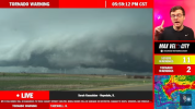
Strong tornado imminent..
Follow along with the video below to see how to install our site as a web app on your home screen.
Note: This feature may not be available in some browsers.


I’m guessing this is what happens when there’s always something that is wrong with a setup up until things do begin to really happen. I wouldn’t say it’s been boring, but 2026 has really been dependent on mesoscale factors so far this season.Very large tornado about to drop; would not be surprised if it is sig+.
On another note, where the heck is everyone? This cell looks more significant than any of the ones yesterday.
Honestly it’s not really impressive on reflectivity at this point. Has that ragged, dog leg appearance where it almost looks outflow dominant.Well, a tornado was there for about 30 seconds, and now it's gone.
Only active thread was for the Moderate Risk (rightfully so). Besides that, it's been very quiet.I’m guessing this is what happens when there’s always something that is wrong with a setup up until things do begin to really happen. I wouldn’t say it’s been boring, but 2026 has really been dependent on mesoscale factors so far this season.
Very quickly organized:Honestly it’s not really impressive on reflectivity at this point. Has that ragged, dog leg appearance where it almost looks outflow dominant.


Looks to have slightly just turned to the right too.The warned cell to the west looks to have the stronger rotation of the two now, but it also looks like it would be rain-wrapped.
Looks to have slightly just turned to the right too.
Edit: looks to be a significant hailer for now