
Navigation
Install the app
How to install the app on iOS
Follow along with the video below to see how to install our site as a web app on your home screen.
Note: This feature may not be available in some browsers.
More options
-
Welcome to TalkWeather! We see you lurking around TalkWeather! Take the extra step and join us today to view attachments, see less ads and maybe even join the discussion. CLICK TO JOIN TALKWEATHER
You are using an out of date browser. It may not display this or other websites correctly.
You should upgrade or use an alternative browser.
You should upgrade or use an alternative browser.
Severe Weather Threat 4/28-4/30
- Thread starter MMWX
- Start date
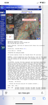
Here was the cap situation 4 hours ago

Here's the cap situation now. it has eroded for half of Iowa.

Here's what it's projected to look like in 2 hours.

Here's the cap situation now. it has eroded for half of Iowa.
Here's what it's projected to look like in 2 hours.
Kds86z
Member
Personally, I'm glad that things ended up underperforming, especially given that I have relatives who live near Minneapolis.
I dunno about that. There's always the chance that things could've played out quite differently today, and it just so happened that (in some kind of "Schroedinger's Cat"-type of way, perhaps?) things played out the way they did in the timeline we live in.
Amen @Tennie! Agree. SPC isn’t perfect and doing their job.
After all, there's a reason why it was meteorology that birthed Chaos Theory!Amen @Tennie! Agree. SPC isn’t perfect and doing their job.
Kds86z
Member
TornadoFan
Member

jiharris0220
Member
The warning signs for this were present pretty much since the cams got into range, the fail modes have already been discussed.
But another particular red flag was that even when cams started convecting the dryline, none of them modeled impressive updraft helicity streaks.
Which can mean two things, anemic updrafts, or updrafts simply not taking advantage of the kinematics they’re in.
The unimpressive streamwise vorticity present on the hodographs alludes to these supercell’s inability to entrain background helicity into their updrafts due to the directional shear.
Today had a potential high ceiling, but the surface low responsible is simply ejecting to fast for the surface winds to back/veer enough to actually get any competent helicity entrainment.
Edit: but perhaps this cell in Kansas will be able to take advantage of the kinematics.
Kds86z
Member
Yeah I wasn’t gonna jinx but.. has hook look..
jiharris0220
Member
And just like that, the velocity couplet is gone, and the storm on the surface is not healthy.
Although to be fair the LLJ here has not intensified at all here yet and honestly even when it does, it will only max out at around 30-45knots.

Although to be fair the LLJ here has not intensified at all here yet and honestly even when it does, it will only max out at around 30-45knots.
Kds86z
Member
US_Highway15
Member

Probably the only worthwhile picture I got today. Got an eight hour drive back.
Is the event over? I'm not an expert but I have seen it before where not much happened during the day and then the night/overnight happened and it all changed.Like has there been a single confirmed tornado today so far?
Kds86z
Member
View attachment 40653
Probably the only worthwhile picture I got today. Got an eight hour drive back.
Lovely @US_Highway15 . E for effort
")
jiharris0220
Member
Not going to happen here fortunately, the inversion layer mows down the convection after midnight as instability becomes to low to sustain sufficiently strong updrafts to resist the increasingly strong LLJ.Is the event over? I'm not an expert but I have seen it before where not much happened during the day and then the night/overnight happened and it all changed.
Kds86z
Member
tornado examiner
Member
If the don’t downgrade the moderate ima be confused
Shakespeare 2016
Member
Well back to the old drawing board on Enhanced Fujita Scale Debate and Significant Tornado Events. It is strange how that occurs quite frequently that it is predictable. This is until the next major tornado outbreak.Not going to happen here fortunately, the inversion layer mows down the convection after midnight as instability becomes to low to sustain sufficiently strong updrafts to resist the increasingly strong LLJ.
AJS
Member
Northern MN storm is tornado warned.
AJS
Member
