Navigation
Install the app
How to install the app on iOS
Follow along with the video below to see how to install our site as a web app on your home screen.
Note: This feature may not be available in some browsers.
More options
-
Welcome to TalkWeather! We see you lurking around TalkWeather! Take the extra step and join us today to view attachments, see less ads and maybe even join the discussion. CLICK TO JOIN TALKWEATHER
You are using an out of date browser. It may not display this or other websites correctly.
You should upgrade or use an alternative browser.
You should upgrade or use an alternative browser.
Severe Weather Threat 4/28-4/30
- Thread starter MMWX
- Start date
Kds86z
Member
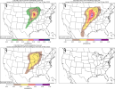
Model soundings from all the main globals continues to suggest an environment easily supportive of EF3+ tornadoes will set up across parts of the upper Midwest on Monday. GFS and GEM aren’t quite to the same extent as ECM, ICON and UKMET, but even then would be a significant tornado threat.
View attachment 40313View attachment 40317
View attachment 40315View attachment 40316
It’s early days, still, but I suspect the extent and magnitude of any severe risk will largely depend on the trough shape and ejection - with which model uncertainty is still somewhat high. Though even if it’s going to be just one or two supercells, as opposed to multiple, that will still pose trouble. Needs close watching and let’s hope things tune down at least a little!
@UK_EF4 has spoken. Got my attention.

US_Highway15
Member


Moderate Risk issued. Looks to be wind-driven though, but the outlook discussion hasn't been released yet.
EDIT: Nope it also includes tornadoes.
....SUMMARY...
An outbreak of severe weather is likely across portions of the
Midwest and Upper Midwest. Large hail, severe wind gusts, and strong
to intense tornadoes are likely.
...A tornado outbreak with the potential for strong to intense
tornadoes is possible on Monday...
...Midwest into the Upper Midwest...
A strong mid-level jet streak will move rapidly northeastward from
the Southwest to the Upper Midwest on Monday. As this occurs, a
surface low will deepen and move from the northern Plains to the
northern Great Lakes. Strong southwesterly lower tropospheric flow
will advect high theta-e air northward across the Midwest and into
parts of the Upper Midwest. Broken to scattered cloud cover will
support surface heating and strong destabilization across the warm
sector in Iowa and into southeast Minnesota and western Wisconsin.
Severe storms may develop as early as mid-day across western
Minnesota and western Iowa on the nose of a 70-80 knot mid-level jet
streak. These storms may begin as supercells, but mode may become
more linear as the cold front intersects the dryline across
Minnesota during the afternoon. Even if mode is more linear,
embedded tornadoes will be possible given the strengthening
low-level shear.
Farther south and east, a more discrete mode will be favored within
a weakly capped warm sector. As lower tropospheric flow strengthens
through the day, the warm sector will expand rapidly northeastward,
creating a broad warm-sector featuring moderate to strong
instability and very strong (60+ knots) shear. Increasing forcing
during the afternoon should be sufficient to overcome weak capping
across the warm sector. Therefore open warm sector supercells will
be possible in addition to supercells along the eastward advancing
dryline. Any supercells which can develop within this increasingly
favorable environment Monday afternoon/evening will be capable of
strong to intense tornadoes. By late evening, a squall line will
likely overtake much of the discrete convection as the cold front
advances rapidly southeast. Severe wind gusts and embedded tornadoes
will remain possible through the late evening and perhaps into the
overnight hours.
...Central/Southern Plains...
A strongly unstable and strongly sheared warm sector will exist
along and east of the dryline from eastern Kansas southward to West
Texas. Forcing is much weaker than farther north with only weak
height falls along the dryline. However, most guidance shows minimal
inhibition along the dryline and at least isolated storm
development, perhaps aided by some nocturnal low-level jet increase
during the evening. Any supercells which develop will pose a threat
for all severe hazards including the potential for strong tornadoes.
..Bentley.. 04/26/2025
The discussion leads with “Tornado Outbreak Likely” so very definitely tornado driven probs on this one.View attachment 40376View attachment 40377
Moderate Risk issued. Looks to be wind-driven though, but the outlook discussion hasn't been released yet.
EDIT: Actually it says possible, sorry.
US_Highway15
Member
Yeah I didn't see that. Edited my post to reflect that.The discussion leads with “Tornado Outbreak Likely” so very definitely tornado driven probs on this one.
AJS
Member
That is a pretty damn strong worded day 3 moderate. Monday really appears to be shaping up that it could be a pretty dangerous day.
Shakespeare 2016
Member
A few dozen long track EF2+ tornadoes along with numerous long track EF4+ tornadoes likely. That would be some terrifying language to hear. Just kidding. It does sound like Monday has some pretty good potential for some long track strong to violent tornadoes.That is a pretty damn strong worded day 3 moderate. Monday really appears to be shaping up that it could be a pretty dangerous day.
tennessee storm chaser
Member
- Messages
- 1,877
- Reaction score
- 4,288
- Location
- jackson tennessee
- Special Affiliations
- SKYWARN® Volunteer
It will easily be tornado driven. OvetYeah I didn't see that. Edited my post to reflect that.
Night models r just plain. Nasty
Aaron Rider
Member
Not the best chasing country if that exact forecast were to hold geographically and verify. That area of WI, IA, and MN is very beautiful but also very hilly and wooded.
Depends how much further southwest into Iowa the tornadoes would be.
Depends how much further southwest into Iowa the tornadoes would be.
lake.effect
Member
Not the best chasing country if that exact forecast were to hold geographically and verify. That area of WI, IA, and MN is very beautiful but also very hilly and wooded.
Depends how much further southwest into Iowa the tornadoes would be.
Most of the MOD area in IA/MN is actually quite ideal for chasing - mostly flat, open farmlands with plenty of square-like roads, few hills and no major forests.
The WI area of MOD is trickier for chasing - that's the so-called "Driftless Zone" which isn't so much heavily forested as it is covered in little valleys and little glacial hills. For the record, that area of Wisconsin is absolutely charming in terms of both geography and people. On my short list of places to go once the big city finally wears me down

But overall it's a very doable chase. I'd much rather chase there versus eastern Tennessee, Arkansas, north Alabama, etc.
notsoencrypted
Member
Of course the highest probabilities are narrowing in on exactly where I need to drive with pets with me in the car on the day I need to drive. Sorry, I am really annoyed by this.
CheeselandSkies
Member
Most of the MOD area in IA/MN is actually quite ideal for chasing - mostly flat, open farmlands with plenty of square-like roads, few hills and no major forests.
The WI area of MOD is trickier for chasing - that's the so-called "Driftless Zone" which isn't so much heavily forested as it is covered in little valleys and little glacial hills. For the record, that area of Wisconsin is absolutely charming in terms of both geography and people. On my short list of places to go once the big city finally wears me down
Yeah, that portion of WI is awful chase terrain. The IA/MN portion is decent until you get close to the river.
notsoencrypted
Member
Most of the MOD area in IA/MN is actually quite ideal for chasing - mostly flat, open farmlands with plenty of square-like roads, few hills and no major forests.
The WI area of MOD is trickier for chasing - that's the so-called "Driftless Zone" which isn't so much heavily forested as it is covered in little valleys and little glacial hills. For the record, that area of Wisconsin is absolutely charming in terms of both geography and people. On my short list of places to go once the big city finally wears me down
But overall it's a very doable chase. I'd much rather chase there versus eastern Tennessee, Arkansas, north Alabama, etc.
Yay, thank you for saying what I wanted to but was too lazy to since I'm on my phone only while my laptop is being repaired (again). The Driftless is pretty and it would be great to have you as a neighbor!
CheeselandSkies
Member
Of course the highest probabilities are narrowing in on exactly where I need to drive with pets with me in the car on the day I need to drive. Sorry, I am really annoyed by this.
Hmmm, keep a radar app handy and be alert for WEAs coming in on your phone. In all honesty I would advice against travel through that area Monday unless you're trying to see the storms like me.
notsoencrypted
Member
Yeah. It's looking like I'm going to have to reschedule for safety, but that's exceedingly frustrating on a personal level. Thank you, and I hope you get to have a great time!Hmmm, keep a radar app handy and be alert for WEAs coming in on your phone. In all honesty I would advice against travel through that area Monday unless you're trying to see the storms like me.
lake.effect
Member
Yay, thank you for saying what I wanted to but was too lazy to since I'm on my phone only while my laptop is being repaired (again). The Driftless is pretty and it would be great to have you as a neighbor!
See what I mean?
")
Also, self-correction: Those aren't glacial hills. That area was never covered by glaciers, hence the name "driftless"
UpperLevelLOL
Member
Incredibly quick jet translation speeds on this, a similar dynamic to what we saw on 4/2. If that continues to be modeled and no other failure modes emerge, this could go high.
I wonder if Broyles is on the desk this weekend…
I wonder if Broyles is on the desk this weekend…
lake.effect
Member
Brolyes memes are the only acceptable use of AI imoIncredibly quick jet translation speeds on this, a similar dynamic to what we saw on 4/2. If that continues to be modeled and no other failure modes emerge, this could go high.
I wonder if Broyles is on the desk this weekend…